Skip to content
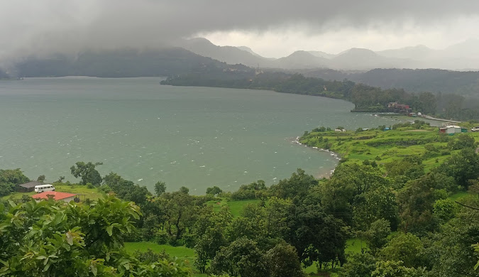
Bhandardara: Maharashtra’s Hidden Gem – A Comprehensive Travel Guide
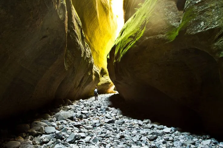
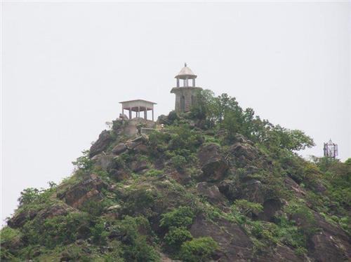
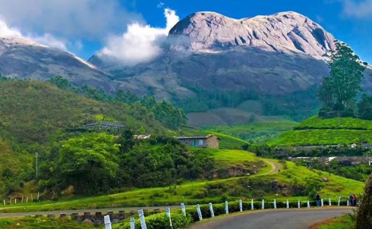
Welcome to Bhandardara: An Overview of its Natural Splendor: Escape the ordinary and discover Bhandardara, Maharashtra’s hidden gem! This comprehensive guide unveils the natural splendor, historical sites, and thrilling adventures awaiting you in this picturesque hill station nestled in the Western Ghats. Bhandardara: Your Ultimate Travel Guide to Maharashtra’s Hidden Paradise Bhandardara stands as a picturesque holiday resort village, gracefully nestled within the Western Ghats of India. Located in the Akole tehsil of Ahmednagar district in Maharashtra, it is frequently characterized as Maharashtra’s “hidden gem”.1 This designation stems from its relatively undiscovered allure, despite being enveloped by a landscape of profound natural beauty. The village is situated serenely by the Pravara River, presenting a harmonious blend of natural environment, including cascading waterfalls, majestic mountains, and the tranquil expanse of Wilson Dam and Arthur Lake.3 The pervasive lush greenery and invigorating air contribute to a pristine ambiance, rendering it a truly idyllic and picture-perfect holiday destination.1 Why Bhandardara? Unveiling its Unique Appeal Bhandardara is recognized as a versatile destination, capable of catering to a broad spectrum of travelers. It appeals to nature enthusiasts, adventure seekers, and individuals desiring a peaceful retreat from the demands of urban life.4 The region offers distinctive opportunities for backpacking, engaging in challenging treks, experiencing lakeside camping under star-filled skies, and exploring ancient forts and temples.1 These diverse offerings collectively ensure a remarkable and unforgettable experience for every visitor, solidifying its reputation as a valuable destination for tourism.1 2. Geographical Location & Accessibility Where is Bhandardara? Bhandardara is strategically positioned in the Ahmednagar district of Maharashtra, in close proximity to Igatpuri, within the majestic Sahyadri ranges of the Western Ghats.1 Its geographical coordinates are 19°31′45″N 73°45′5″E, and it is situated at an elevation of 740 meters (2,430 ft) above mean sea level.3 A central feature of the village’s natural setting is its location on the banks of the Pravara River, which is integral to many of its primary attractions, including the notable Wilson Dam and Arthur Lake.3 How to Reach Bhandardara: Your Journey Options Bhandardara is accessible through various modes of transportation, connecting it to major urban centers in Maharashtra. Getting Around Bhandardara: Local Transport Tips Within Bhandardara itself, local transport facilities are somewhat limited. As a smaller hill station, options for getting around are not as extensive as in larger urban areas, primarily consisting of local buses that ply from Igatpuri.10 This limited availability of internal transport means that visitors should plan their mobility carefully. For those who drive to Bhandardara, utilizing their own vehicle for local sightseeing is the most convenient approach. Alternatively, resorts may facilitate cab arrangements upon request for their guests.10 Relying on spontaneous local transport within the village might prove challenging, potentially impacting the overall sightseeing experience. The explicit warnings about narrow roads while driving on the ghats and the scarcity of local transport within Bhandardara underscore the critical importance of pre-arranged transport for local exploration. 3. Best Time to Visit: Unveiling Bhandardara’s Seasonal Charms Overview of Bhandardara’s Climate Bhandardara experiences three distinct primary seasons—summer, monsoon, and winter—each uniquely transforming the landscape and offering varied experiences.14 The timing of a visit significantly influences sightseeing comfort and the availability of specific activities, including season-specific wonders such as the firefly festivals.14 The optimal period for a visit is not a singular timeframe but rather contingent on a traveler’s primary interests and desired activities. This allows for tailored recommendations rather than a universal “best time to visit.” Monsoon Magic (July – September) The monsoon season in Bhandardara is often described as “magical,” as rainfall invigorates the natural environment, leading to lush greenery and spectacular displays of overflowing waterfalls.4 Attractions such as Randha Falls and Umbrella Falls reach their full glory during this period.4 While enchanting for nature lovers, heavy rains and elevated humidity can render trekking trails slippery, necessitating caution.1 Evenings, however, are typically breezy and pleasant, providing an ideal setting for picnics near the swollen waterfalls and dams.1 Average July temperatures range from a high of 27°C (81°F) to a low of 22°C (72°F).15 This month experiences a very high probability of rain (98%), with heavy precipitation averaging around 25.6 mm per day, accompanied by high humidity (98%).15 The detailed monthly weather data, particularly for the monsoon months, provides critical actionable information for travelers. Knowing the high chance of heavy rain, high humidity, and recommended attire such as a sleeveless shirt, raincoat, and rain boots for July enables precise packing and preparation, thereby mitigating potential discomforts and enhancing the overall trip experience.15 Winter Wonderland (October – February) Winter in Bhandardara is widely regarded as the best time to visit by many, offering cool, pleasant weather and crisp, clear skies that are conducive to outdoor adventures and relaxation.1 This period is perfectly suited for embarking on treks to historical forts and majestic peaks like Ratangad, Harishchandragad, and Mount Kalsubai.9 It also presents a charming opportunity for cozy retreats by Arthur Lake, stargazing, and photography.9 Temperatures typically remain below 20°C 1, with December and January experiencing average highs around 28°C and lows between 15-18°C, along with minimal rainfall.16 Summer Escapes (March – June) Summer generally represents a quieter, less crowded period in Bhandardara. While the weather tends to be warmer, with days often hot and humid (averaging a maximum of 36°C), nights can cool down considerably.4 Arthur Lake and Wilson Dam continue to offer refreshing experiences even under warmer skies.14 This season is well-suited for peaceful retreats, discovering secluded spots, engaging in leisurely village walks, and camping near the lakes.9 Occasional pre-monsoon showers in May can contribute to a reduction in temperatures.9 Below is a consolidated overview of Bhandardara’s monthly weather, providing a quick reference for planning purposes: Month Average High Temp (°C / °F) Average Low Temp (°C / °F) Average Rain Days Average Precipitation (mm / inches) Average Relative Humidity (%) Average Clear/Sunny Hours per Day Average Wind Speed (mph / kph) January 28° / 82° 15° / 59° 0 – – 19.2 – February 31° / 88° 17° / 63° 0 –
Bhandardara: Maharashtra’s Hidden Gem – A Comprehensive Travel Guide Read More »