South America Travel

Explore South America travel guides, itineraries, places to visit, travel tips, cultural experiences, and destination insights across popular countries and cities in South America.

What to Do in Salta: The Ultimate 2025 Travel Guide to Salta City & Beyond

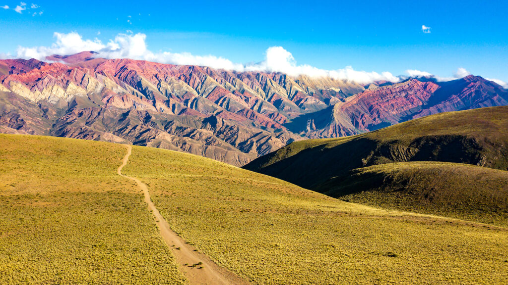
Picture this: cobblestone streets lined with colonial buildings painted in sunset colors, mountain peaks touching cotton-candy clouds, and the sound of folk guitars drifting from candlelit doorways. Welcome to Salta la Linda—Salta the Beautiful—a city that sits pretty in Argentina’s northwest corner and refuses to follow the rules of typical South American travel. Most travelers zoom straight to Patagonia or Buenos Aires, but those in the know? They head north to Salta. This isn’t just another pretty colonial city (though it absolutely is that). It’s your gateway to some of the most jaw-dropping landscapes in Argentina—think rainbow mountains, endless salt flats that mess with your sense of reality, and wine valleys tucked between red-rock canyons. This guide covers everything you need to know about what to do in Salta, from wandering the city’s historic plazas to planning epic day trips into the surrounding Andes. Whether you’re here for three days or three weeks, we’ve got the insider scoop on attractions, logistics, local experiences, and those secret spots that make travel magical. Quick Salta Travel Information Category Details Best Time to Visit April-May & September-November (shoulder seasons) Airport Code SLA (Martín Miguel de Güemes International Airport) Altitude City: 1,187m (3,894 ft) / Excursions: Up to 4,170m (13,680 ft) Recommended Stay 4-6 days (2 city + 2-4 excursions) Currency Argentine Peso (ARS) – bring USD for better exchange rates Must-Try Empanadas Salteñas, Locro stew, Torrontés wine Don’t Miss Peña folklórica show, MAAM museum, Quebrada de las Conchas Budget Range Backpacker: $30-50/day | Mid-Range: $70-120/day | Luxury: $150+/day Getting to and Getting Around Salta How to Reach Salta Flying into Salta (SLA) is your easiest bet. Direct flights connect from Buenos Aires (2-hour flight), plus seasonal connections from other Argentine cities. The airport sits about 10 kilometers from downtown, making transfers quick and painless. If you’re doing the overland adventure thing, long-distance buses run from Buenos Aires (20+ hours—not for the faint of heart), Tucumán (4 hours), and other northern cities. Argentina’s bus system is surprisingly comfortable with reclining seats and meal service, but time-wise, flying makes way more sense unless you’re on a serious budget. Getting Around: Your Options Decoded Here’s where trip planning gets interesting. Salta city attractions are totally walkable—you can cover the historic center on foot in a day. But those incredible day trips? You’ve got choices: Rental Car (Best for Freedom Seekers)Renting a car gives you complete control over your schedule. The roads around Salta are generally good, though mountain passes require confidence with switchbacks and altitude. Gas stations exist but get sparse once you head into remote areas. This works beautifully if you want to stop every five minutes for photos (and trust me, you will). Organized Tours (Best for Ease)Nearly every hotel and hostel can book you on guided day trips. You’ll share a minibus with other travelers, hit all the highlights, and learn from local guides. The downside? Fixed schedules and less flexibility. Tours typically run 12-14 hours for the full-day excursions. Public Transport (Budget Option)Buses connect Salta to major towns like Cafayate and Cachi, but they don’t stop at scenic viewpoints along the way. You’ll miss photo ops at places like Quebrada de las Conchas. Only recommended if you’re seriously stretching pesos. Our Take: First-timers and solo travelers often prefer tours for the first excursion, then rent a car if they want more freedom. Families and groups find rental cars more economical when you split costs. Weather Watch Salta enjoys sunshine about 300 days a year, but seasons matter. Summer (December-February) brings afternoon rain and higher temperatures. Winter (June-August) delivers crystal-clear skies but chilly nights—especially at altitude. The sweet spot? April-May and September-November offer comfortable temps, fewer crowds, and perfect road conditions for exploring. Top Things to Do in Salta (City) – Your 1-Day Itinerary Morning: Museum Magic at MAAM Start your day at the Museo Arqueológico de Alta Montaña (MAAM)—possibly the most fascinating museum you’ve never heard of. This isn’t your dusty artifact warehouse. MAAM houses three incredibly preserved Inca children discovered at 6,700 meters on volcanic peaks, naturally mummified by extreme cold and altitude. The museum tells their story with respect and scientific rigor, explaining Inca capacocha ceremonies and high-altitude archaeology. It’s profound, moving, and completely unique. Plan for 60-90 minutes here. Check the official MAAM website for current hours and rotating exhibits—only one child is displayed at a time to ensure preservation. Late Morning: Colonial Center Circuit From MAAM, wander over to Plaza 9 de Julio, Salta’s beating heart. This isn’t just any plaza—it’s one of Argentina’s most beautiful, surrounded by orange trees and colonial architecture that’ll have your camera working overtime. Hit these spots around the plaza: Grab lunch at one of the cafes lining the plaza. Order empanadas salteñas—these aren’t your average empanadas. Salta-style means they’re smaller, perfectly spiced with cumin, and stuffed with beef, potatoes, and hard-boiled egg. Afternoon: Rise to Cerro San Bernardo After lunch, take the teleférico (cable car) up Cerro San Bernardo for panoramic views over the entire Lerma Valley. The city spreads below you in a patchwork of terracotta roofs and green plazas, with mountains rising dramatically in every direction. Feeling energetic? Skip the cable car and hike the 1,070 steps instead. The trail winds through gardens and past stations of the cross. It takes about 45 minutes and rewards you with that smug “I earned this view” feeling. Evening: Peña Folklórica Experience Here’s where Salta really shows its personality. A peña folklórica is a folk-music dinner show, but calling it that undersells the experience. These intimate venues pulse with traditional Argentine music—zambas, chacareras, and the haunting sound of bombo drums mixed with guitars. Locals pack these places on weekends, singing along and sometimes spontaneously joining the dancing. Try La Casona del Molino or Peña Gauchos de Güemes. You’ll eat regional dishes like locro (a hearty stew), humita (corn tamales), and tamales salteños while musicians rotate through sets. Pro tip: Peñas get crowded on Friday and Saturday nights—make reservations or arrive early. The

What to Do in Salta: The Ultimate 2025 Travel Guide to Salta City & Beyond Read More »

What to Do in Salento, Colombia: 10 Unforgettable Experiences Beyond the Wax Palms

Picture this: you’re standing on a cobblestone street lined with candy-colored colonial houses, each one painted in shades of sunshine yellow, electric blue, and fiery orange. The air smells like freshly brewed coffee mixed with the earthy scent of rain on mountain soil. Behind you, the Andes Mountains rise up like sleeping giants, and somewhere in the distance, the world’s tallest palm trees are swaying in the breeze like nature’s own skyscrapers. Welcome to Salento, Colombia—a tiny mountain town that punches way above its weight when it comes to charm, adventure, and pure travel magic. Whether you’re a solo traveler looking for your next adventure, a family planning a holiday that combines nature and culture, or just someone who wants to escape the noise of everyday life, Salento has something special waiting for you. This isn’t your typical tourist trap. Sure, everyone knows about the famous wax palms in Valle de Cocora, but what to do in Salento Colombia goes far beyond that single (admittedly spectacular) experience. In this guide, I’ll walk you through 10 unforgettable experiences that showcase the real heart of this Salento Colombia coffee region gem. From hiking cloud forests to sipping coffee straight from the farm, exploring hidden waterfalls, and even learning a quirky local game involving gunpowder (yes, really!), you’re about to discover why Salento should be at the top of your Colombia bucket list. Quick Information Table Category Details Best Time to Visit December to March (dry season) or June to August Recommended Stay 3-4 days for full experience; 2 days minimum Main Activities Hiking, coffee tours, viewpoints, day trips Getting There Fly to Pereira or Armenia, then 1-hour bus ride Budget Range $30-60 USD per day (mid-range traveler) Ideal For Solo travelers, families, nature lovers, coffee enthusiasts Language Spanish (basic English in tourist areas) Safety Level Very safe for tourists, including solo travelers Planning Your Salento Adventure: Getting There & Orienting Yourself How to Reach Salento Getting to Salento is easier than you might think, though it does require a bit of planning. The town sits in Colombia’s Coffee Triangle (Eje Cafetero), nestled between the larger cities of Armenia and Pereira. By Air: Your best bet is flying into either Matecaña International Airport in Pereira (45 minutes away) or El Edén International Airport in Armenia (30 minutes away). [Cite Source: Colombian Civil Aviation Authority]. From there, you’ll hop on a local bus or arrange a private transfer. Buses run regularly throughout the day and cost around 8,000-10,000 Colombian pesos (roughly $2-3 USD). By Bus: If you’re coming from Bogotá, expect a scenic 8-10 hour bus journey through the mountains. From Medellín, it’s about 6-7 hours. Companies like Expreso Bolivariano and Expreso Palmira offer comfortable overnight buses with reclining seats. [Cite Source: Terminal de Transporte websites] Pro Tip for Solo Travelers: The bus terminals in Pereira and Armenia are safe, but arrive during daylight hours if possible. Keep your valuables close and use official taxi services or apps like DiDi or InDriver for the final leg to Salento. Orienting Yourself in Town Salento is wonderfully compact—you can walk from one end to the other in about 15 minutes. The heart of town is the Plaza de Bolívar, surrounded by restaurants, artisan shops, and cafés. From the plaza, Calle Real (also called Carrera 6) is the Instagram-famous street lined with colorful colonial architecture that climbs uphill toward the Mirador Alto de la Cruz. The Mirador Salento Colombia view is worth the 240-step climb. You’ll get panoramic views of the valley below, with the wax palms of Cocora visible on clear days. Go at sunset for the most dramatic lighting—the golden hour turns those colorful buildings into something out of a storybook. Best Time to Visit Salento Colombia Timing matters in the mountains. Salento has two dry seasons: December through March and June through August. These months offer the clearest skies for hiking the Cocora Valley wax palms trail and exploring surrounding nature. That said, this is the cloud forest—rain is part of the charm. Even during “dry” season, afternoon showers are common. The rainy seasons (April-May and September-November) bring lush green landscapes and fewer crowds, though trails can get muddy. Weekend vs. Weekday: Salento gets packed with Colombian tourists on weekends and holidays. If you’re looking for a quieter experience, visit mid-week. You’ll have trails more to yourself and won’t wait in line for jeeps to Cocora Valley. Where to Stay Accommodation options range from $10 USD hostel dorms to $80+ boutique hotels. For solo travel Salento Colombia adventures, try hostels like The Plantation House or La Serrana Eco Farm Hostel—both are social spots perfect for meeting other travelers. Families might prefer places like Hotel Salento Real or Casa de las Palmas, which offer private rooms with mountain views. The Magnificent Outdoors: Salento’s Must-Do Nature Experiences Hiking the Legendary Valle de Cocora Let’s be honest—the Cocora Valley wax palms are the main reason most people come to Salento, and they absolutely live up to the hype. These towering Quindío wax palms (Ceroxylon quindiuense) are Colombia’s national tree and the tallest palm species on Earth, reaching heights of up to 200 feet. Seeing them rising out of the misty valley feels like stepping onto another planet. The Hiking Options: There are two main ways to experience Valle de Cocora: 1. The Full Loop (5-6 hours): This 14-kilometer trail takes you through cloud forest, across rickety wooden bridges, past rushing rivers, and finally into the valley where the palms stand like natural monuments. The route is moderately challenging with some steep sections and stream crossings. [Cite Source: Colombian National Parks Service] Is the hike in Cocora Valley hard? I’ll be straight with you—it’s not a walk in the park, but it’s totally doable for anyone with average fitness. The elevation (you’ll be between 2,400-2,800 meters above sea level) might leave you breathing harder than usual. Wear good hiking boots, bring rain gear, and pack snacks and water. 2. The Short Walk (1-2 hours): If you’re short

What to Do in Salento, Colombia: 10 Unforgettable Experiences Beyond the Wax Palms Read More »

aysen region, chile

Navigating Aysen: An Expert’s Guide to Chile’s Untamed Patagonian Frontier

Part I: The Call of the Wild: Why Aysén is Chile’s Untamed Frontier Aysén: An Introduction to Patagonia’s Hidden Heart The Aysén Region, officially known as the Aysén del General Carlos Ibáñez del Campo Region, is a sprawling, untamed expanse nestled deep within Chilean Patagonia. Situated south of the Lakes District and north of the famed Torres del Paine National Park, it exists as a remote and off-the-beaten-path destination for those seeking genuine adventure.1 It is a land of dramatic geographical contrasts, bordered by the intricate maze of Pacific Ocean fjords to the west and the formidable Andes Mountains to the east. This rugged landscape is a dynamic mosaic of majestic mountains, colossal glaciers, and two of the largest ice fields in the world: the Northern and Southern Patagonian Ice Fields. The Northern Ice Field is contained entirely within the borders of Laguna San Rafael National Park.1 The region’s terrain is characterized by glaciated valleys and fjords, with mountain elevations ranging from 1,000 to 4,000 meters. The lower slopes are blanketed by dense, broad-leaved evergreen forests, while perennial snowfields cap the higher peaks.3 For administrative purposes, Aysén is divided into four provinces: Aisén, General Carrera, Coihaique, and Capitán Pratt.3 The regional capital and largest urban center is the city of Coihaique, which serves as a vital hub for the entire region’s travel and commerce.2 While human settlements are sparse, the region’s rivers, such as the turbulent Baker River, are among the most powerful in Chile. The regional economy, while small, is traditionally based on animal husbandry, particularly sheep and cattle, as well as the production of timber and, to a lesser extent, mining for gold, silver, and zinc.3 The Route of the Parks: A Backbone of Conservation At the very core of a journey through Aysén is the Carretera Austral, or Southern Highway. This legendary road, also known as Ruta 7, is the region’s primary artery, snaking its way for approximately 1,240 kilometers (770 miles) from Puerto Montt in the north to the remote outpost of Villa O’Higgins in the south.2 This road is not merely a means of transportation but a destination in itself, renowned as one of the most spectacular scenic drives in the world and a true bucket-list item for any traveler.1 The Carretera Austral is a centerpiece of a much larger, globally significant conservation project: the Route of the Parks (Ruta de los Parques). This initiative is a monumental 2,735-kilometer conservation trail that connects 17 national parks, forming a contiguous protected corridor from Puerto Montt all the way to Cape Horn.5 The grand vision behind this route is to protect an astonishing 11.8 million hectares of pristine ecosystems—an area nearly three times the size of Switzerland—to serve as a “natural solution” to the global crisis of biodiversity loss and climate change.9 The project, which is a collaborative effort between the public and private sectors, aims to foster an economy based on low-impact nature tourism, ensuring that the local communities and the environment thrive in harmony.8 The Aysén region is a critical component of this effort, containing national park gems such as Patagonia National Park and Cerro Castillo National Park.8 It is essential for travelers to understand that the Carretera Austral is a dynamic and evolving entity, not a static feature on a map. While travel guides and blogs have long described it as a “mostly unpaved” or “dirt road,” this characterization is becoming increasingly outdated, particularly for certain sections.1 Research indicates that significant “ongoing road works” have resulted in approximately half of the route already being paved.12 More specifically, the northern section, from Puerto Montt to Coihaique, is now “mostly tarred” with only intermittent unpaved stretches.12 In contrast, the southern portion, from Coihaique to Villa O’Higgins, remains “mostly gravel road”.12 This continuous transformation has profound implications for a traveler’s journey, directly affecting travel time, vehicle choice, and the overall experience. The perceived need for a 4×4, for example, is becoming less universal and is now most critical only for those planning to drive on narrow mountain roads or cross certain remote border crossings into Argentina.13 This nuanced reality challenges the long-held image of the highway and requires more precise planning than in previous years. Table 1: The Aysén Travel Hubs at a Glance Town Name Role Key Attractions Available Services Coyhaique Regional Capital, Transport Hub Main Square, Coyhaique National Reserve, Hub for adventure tours ATM, Gas, Supermarket, Restaurants, Hotels 5 Puyuhuapi Fjord-side Village Puyuhuapi Hot Springs, German-influenced architecture Gas (Diesel only), Lodges, Restaurants 5 Puerto Río Tranquilo Glacier & Lake Gateway Marble Caves (Capillas de Mármol), Exploradores Glacier ATM, Gas, Lodges, Tour Operators 5 Chile Chico Lakeside Town Views of Lake General Carrera, Jeinimeni National Reserve ATM, Gas, Supermarket 5 Cochrane Conservation Hub Patagonia National Park, Fly-fishing ATM, Gas, Lodges, Restaurants 5 Villa O’Higgins End of the Road End of Carretera Austral, O’Higgins Glacier ATM, Gas 5 Part II: Preparing for the Expedition: Essential Planning & Logistics The Travel Arc: Getting to and Around Aysén Accessing the Aysén region, a land defined by its remoteness, requires careful logistical planning. The most frequent and efficient method of arrival is by air. The main gateway is Balmaceda Airport (BBA), located just 56 km southeast of the regional capital, Coihaique.14 Currently, there are no direct international flights to Balmaceda; travelers must first fly into Santiago (SCL) and then take a domestic flight, a journey of approximately 2.5 hours.14 Balmaceda also serves as a crucial hub for domestic air travel, with daily flights connecting it to Puerto Montt (PMC) and regular services to Punta Arenas (PUQ), effectively linking Aysén to the rest of Patagonia and Chile’s Lakes District.16 For a more immersive and scenic approach, the region is also well-connected by sea. Multi-day adventure cruises, such as those operated by Skorpios, embark from Puerto Montt and navigate the labyrinthine fjords and islands, with itineraries often culminating at the magnificent San Rafael Glacier.16 For those who prefer a more relaxed, multi-day journey, the Navimag ferry provides a breathtaking four-day/three-night trip

Navigating Aysen: An Expert’s Guide to Chile’s Untamed Patagonian Frontier Read More »