Research Destination Guide

aysen region, chile

Navigating Aysen: An Expert’s Guide to Chile’s Untamed Patagonian Frontier

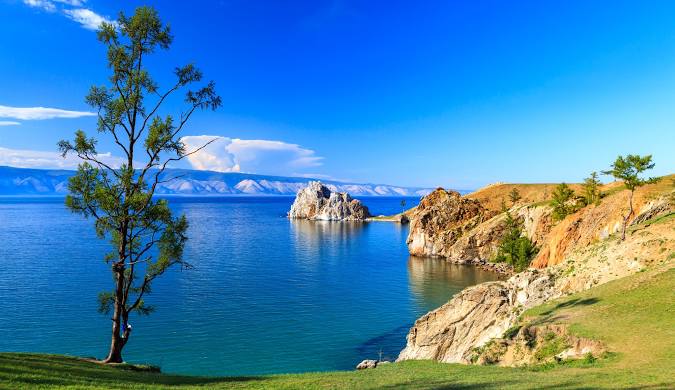
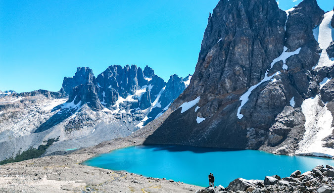
Part I: The Call of the Wild: Why Aysén is Chile’s Untamed Frontier Aysén: An Introduction to Patagonia’s Hidden Heart The Aysén Region, officially known as the Aysén del General Carlos Ibáñez del Campo Region, is a sprawling, untamed expanse nestled deep within Chilean Patagonia. Situated south of the Lakes District and north of the famed Torres del Paine National Park, it exists as a remote and off-the-beaten-path destination for those seeking genuine adventure.1 It is a land of dramatic geographical contrasts, bordered by the intricate maze of Pacific Ocean fjords to the west and the formidable Andes Mountains to the east. This rugged landscape is a dynamic mosaic of majestic mountains, colossal glaciers, and two of the largest ice fields in the world: the Northern and Southern Patagonian Ice Fields. The Northern Ice Field is contained entirely within the borders of Laguna San Rafael National Park.1 The region’s terrain is characterized by glaciated valleys and fjords, with mountain elevations ranging from 1,000 to 4,000 meters. The lower slopes are blanketed by dense, broad-leaved evergreen forests, while perennial snowfields cap the higher peaks.3 For administrative purposes, Aysén is divided into four provinces: Aisén, General Carrera, Coihaique, and Capitán Pratt.3 The regional capital and largest urban center is the city of Coihaique, which serves as a vital hub for the entire region’s travel and commerce.2 While human settlements are sparse, the region’s rivers, such as the turbulent Baker River, are among the most powerful in Chile. The regional economy, while small, is traditionally based on animal husbandry, particularly sheep and cattle, as well as the production of timber and, to a lesser extent, mining for gold, silver, and zinc.3 The Route of the Parks: A Backbone of Conservation At the very core of a journey through Aysén is the Carretera Austral, or Southern Highway. This legendary road, also known as Ruta 7, is the region’s primary artery, snaking its way for approximately 1,240 kilometers (770 miles) from Puerto Montt in the north to the remote outpost of Villa O’Higgins in the south.2 This road is not merely a means of transportation but a destination in itself, renowned as one of the most spectacular scenic drives in the world and a true bucket-list item for any traveler.1 The Carretera Austral is a centerpiece of a much larger, globally significant conservation project: the Route of the Parks (Ruta de los Parques). This initiative is a monumental 2,735-kilometer conservation trail that connects 17 national parks, forming a contiguous protected corridor from Puerto Montt all the way to Cape Horn.5 The grand vision behind this route is to protect an astonishing 11.8 million hectares of pristine ecosystems—an area nearly three times the size of Switzerland—to serve as a “natural solution” to the global crisis of biodiversity loss and climate change.9 The project, which is a collaborative effort between the public and private sectors, aims to foster an economy based on low-impact nature tourism, ensuring that the local communities and the environment thrive in harmony.8 The Aysén region is a critical component of this effort, containing national park gems such as Patagonia National Park and Cerro Castillo National Park.8 It is essential for travelers to understand that the Carretera Austral is a dynamic and evolving entity, not a static feature on a map. While travel guides and blogs have long described it as a “mostly unpaved” or “dirt road,” this characterization is becoming increasingly outdated, particularly for certain sections.1 Research indicates that significant “ongoing road works” have resulted in approximately half of the route already being paved.12 More specifically, the northern section, from Puerto Montt to Coihaique, is now “mostly tarred” with only intermittent unpaved stretches.12 In contrast, the southern portion, from Coihaique to Villa O’Higgins, remains “mostly gravel road”.12 This continuous transformation has profound implications for a traveler’s journey, directly affecting travel time, vehicle choice, and the overall experience. The perceived need for a 4×4, for example, is becoming less universal and is now most critical only for those planning to drive on narrow mountain roads or cross certain remote border crossings into Argentina.13 This nuanced reality challenges the long-held image of the highway and requires more precise planning than in previous years. Table 1: The Aysén Travel Hubs at a Glance Town Name Role Key Attractions Available Services Coyhaique Regional Capital, Transport Hub Main Square, Coyhaique National Reserve, Hub for adventure tours ATM, Gas, Supermarket, Restaurants, Hotels 5 Puyuhuapi Fjord-side Village Puyuhuapi Hot Springs, German-influenced architecture Gas (Diesel only), Lodges, Restaurants 5 Puerto Río Tranquilo Glacier & Lake Gateway Marble Caves (Capillas de Mármol), Exploradores Glacier ATM, Gas, Lodges, Tour Operators 5 Chile Chico Lakeside Town Views of Lake General Carrera, Jeinimeni National Reserve ATM, Gas, Supermarket 5 Cochrane Conservation Hub Patagonia National Park, Fly-fishing ATM, Gas, Lodges, Restaurants 5 Villa O’Higgins End of the Road End of Carretera Austral, O’Higgins Glacier ATM, Gas 5 Part II: Preparing for the Expedition: Essential Planning & Logistics The Travel Arc: Getting to and Around Aysén Accessing the Aysén region, a land defined by its remoteness, requires careful logistical planning. The most frequent and efficient method of arrival is by air. The main gateway is Balmaceda Airport (BBA), located just 56 km southeast of the regional capital, Coihaique.14 Currently, there are no direct international flights to Balmaceda; travelers must first fly into Santiago (SCL) and then take a domestic flight, a journey of approximately 2.5 hours.14 Balmaceda also serves as a crucial hub for domestic air travel, with daily flights connecting it to Puerto Montt (PMC) and regular services to Punta Arenas (PUQ), effectively linking Aysén to the rest of Patagonia and Chile’s Lakes District.16 For a more immersive and scenic approach, the region is also well-connected by sea. Multi-day adventure cruises, such as those operated by Skorpios, embark from Puerto Montt and navigate the labyrinthine fjords and islands, with itineraries often culminating at the magnificent San Rafael Glacier.16 For those who prefer a more relaxed, multi-day journey, the Navimag ferry provides a breathtaking four-day/three-night trip

Navigating Aysen: An Expert’s Guide to Chile’s Untamed Patagonian Frontier Read More »

How Niagara Falls Was Formed: Geological Story, Hidden History & What It Means Today

Ever wondered what it would look like to see a river carve through solid rock? That’s exactly the story of Niagara Falls—a spectacular tale of ice, water, and time that began over 12,000 years ago. Standing at the edge of this thundering cascade, you’re witnessing one of nature’s most incredible construction projects, where how Niagara Falls was formed involves a perfect storm of geological forces that continue shaping our world today. This isn’t just another tourist attraction story. The formation of Niagara Falls is a masterclass in geological drama, featuring massive ice sheets, ancient buried valleys, and a recipe of rock layers that created the perfect conditions for one of the world’s most famous waterfalls. By understanding this incredible journey, you’ll discover how glacial melting, the birth of the Great Lakes, and the unique Niagara Escarpment combined to create this natural wonder that continues evolving before our eyes. Based on well-documented geological findings from leading institutions, this story will take you on a 12,000-year journey that transforms how you see this iconic waterfall forever. Quick Information Table Formation Details Information Age of Niagara Falls Approximately 12,000 years old Formation Period End of last Ice Age (Wisconsin Glaciation) Primary Formation Process Glacial meltwater erosion over Niagara Escarpment Key Rock Layers Lockport Formation (hard caprock) over Rochester/Queenston Formation (soft shale) Current Retreat Rate About 1 foot per year (reduced from 3-5 feet due to hydroelectric diversions) Total Gorge Length 7 miles from Lewiston to current falls location Height of Falls 167 feet (Horseshoe Falls), 70 feet (American Falls) Water Source Great Lakes drainage system via Niagara River Future Projection Will reach Lake Erie in approximately 50,000 years Daily Water Flow 6 million cubic feet per minute (peak flow) The Ancient Landscape: A World Covered in Ice Picture this: 20,000 years ago, where Niagara Falls now thunders, there was nothing but ice. Lots of ice. The massive Wisconsin Glacier, part of the last great Ice Age, stretched across most of northeastern North America like a frozen blanket up to two miles thick. This wasn’t just any ordinary ice sheet—it was a geological bulldozer that completely reshaped the landscape beneath it. The Wisconsin Glacier did more than just cover the land. As it slowly crept across the region, it carved deep valleys, scraped away hilltops, and completely rearranged the drainage patterns that had existed for millions of years. One of the most fascinating discoveries in understanding how Niagara Falls was formed is the Saint David’s Buried Gorge—a “ghost river” valley that the glacier filled with debris and sediment. This ancient valley, now hidden beneath layers of glacial deposits, tells us that water was carving paths through this landscape long before our modern Niagara River existed. The glacier essentially hit the reset button on the entire region’s geography, setting the stage for something completely new to emerge once the ice began its final retreat. The sheer weight of this ice sheet also pressed down on the Earth’s crust, causing the land to sink. This geological process, called isostatic depression, would later play a crucial role in shaping the Great Lakes and the drainage patterns that would eventually create the Niagara River. A New Beginning: The Ice Melts and a Mighty River Awakens Around 12,000 years ago, the climate began to warm, and the Wisconsin Glacier started its dramatic retreat. But this wasn’t a gentle melting process—it was an explosive geological event that released unimaginable amounts of water across the landscape. Imagine trying to drain a bathtub the size of several states all at once. That’s the scale of glacial melting that reshaped this region. As the massive ice sheet melted, it created temporary lakes, raging rivers, and floods that would make today’s most extreme weather events look like gentle spring showers. The meltwater had to go somewhere, and it began filling the deep basins that the glacier had carved during its advance. These basins would become what we now know as the Great Lakes—Erie, Ontario, Huron, Michigan, and Superior. The formation of these Great Lakes created an entirely new drainage system. Water from the upper Great Lakes now needed to flow toward the Atlantic Ocean, and the most direct route was through the newly formed connection between Lake Erie and Lake Ontario. This connection became the Niagara River, born from the Great Lakes drainage system that the glacier had inadvertently designed. Here’s where the story gets interesting: this new Niagara River needed to find its way from the higher elevation of Lake Erie (about 571 feet above sea level) down to Lake Ontario (about 245 feet above sea level). That 326-foot elevation difference meant the water would flow with tremendous force—but where exactly it would flow depended on what kind of rock it encountered along the way. The Niagara Escarpment: Nature’s Perfect Recipe for a Waterfall Think of the Niagara Escarpment as a giant layer cake made of different kinds of rock, each with its own personality when it comes to dealing with flowing water. This ancient cliff face, formed hundreds of millions of years ago, stretches for hundreds of miles through Ontario, New York, Wisconsin, and Michigan. But it’s here at Niagara where it created the perfect conditions for a spectacular waterfall. The “frosting” on this geological layer cake is the Lockport Formation—a tough, hard layer of limestone and dolomite that geologists call caprock. This rock formed about 430 million years ago when this area was covered by a warm, shallow sea. The limestone is incredibly resistant to erosion, which means water has a tough time wearing it away. It’s like nature’s concrete, holding firm against the pounding of millions of gallons of water. Beneath this hard caprock lies the “cake” itself—softer rock layers, particularly the Rochester Formation, made up of shale and other sedimentary rocks. These softer layers are like geological butter compared to the limestone frosting above them. When water hits these rocks, they crumble and wash away relatively easily. The Queenston Formation, even deeper in this rock layer cake, consists

How Niagara Falls Was Formed: Geological Story, Hidden History & What It Means Today Read More »

Swiss Train

Swiss Train Travel Guide for Indians: Tickets, Passes, and Cost Explained

Picture this: A gleaming red train winds through snow-capped peaks, past pristine lakes that mirror the sky, while you sit comfortably inside, watching one of the world’s most spectacular landscapes unfold before your eyes. Have you ever dreamt of this iconic Swiss experience? Switzerland’s trains are legendary worldwide for three reasons: unmatched punctuality, exceptional efficiency, and breathtaking scenic routes that transform travel into the destination itself. For Indian travelers, mastering the Swiss train system isn’t just about getting from point A to point B—it’s your golden ticket to unlocking Switzerland’s true alpine magic. This comprehensive guide is specifically crafted for Indian travelers navigating the intricacies of Swiss rail travel. We’ll demystify everything from the various types of passes and individual tickets to purchasing strategies and cost considerations. Getting your hands on the right Swiss train tickets can seem daunting at first, but this guide will transform that complexity into confidence, ensuring your Swiss adventure runs as smoothly as the trains themselves. Why Swiss Trains are a Traveler’s Dream Swiss train travel transcends mere transportation—it’s an integral part of your alpine adventure. Imagine settling into plush seats behind floor-to-ceiling panoramic windows, feeling the gentle rhythm of rails as you glide effortlessly through landscapes that look like postcards come to life. These aren’t just trains; they’re moving observation decks offering front-row seats to some of Earth’s most stunning scenery. The legendary punctuality of Swiss trains is a game-changer for Indian travelers accustomed to uncertain schedules. Swiss Federal Railways operates with clockwork precision—trains arrive and depart exactly on time, allowing you to plan your itinerary with military precision and maximize every precious moment of your vacation. The extensive network connects bustling cities to remote mountain villages with remarkable efficiency. Whether you’re traveling from cosmopolitan Zurich to the car-free streets of Zermatt or from lakeside Geneva to the Alpine paradise of Interlaken, trains reach destinations that would require winding mountain drives, eliminating the stress of navigation and parking. Perhaps most remarkably, certain routes like the famous Glacier Express and Bernina Express aren’t just transportation—they’re world-renowned experiences in themselves. These panoramic journeys transform travel time into unforgettable memories, making the journey every bit as spectacular as the destination. Decoding Swiss Train Tickets & Passes for Indians Switzerland offers a sophisticated array of travel options designed to accommodate different itineraries, budgets, and travel styles. Understanding these options is crucial for making informed decisions that can significantly impact both your experience and expenses. The Swiss Travel Pass The Swiss Travel Pass stands as Switzerland’s premier travel solution—an all-in-one ticket providing unlimited travel across the country’s entire network of trains, buses, and boats. Think of it as your master key to Switzerland’s transportation system. For Indian travelers, the convenience factor cannot be overstated. Instead of fumbling with individual tickets for each journey, you simply hop on and off trains at will. The Swiss Travel Pass for Indians offers exceptional value through its additional benefits: free entry to over 500 museums across the country, which alone can save hundreds of francs for culture enthusiasts. The pass comes in two variants: consecutive passes (valid for continuous days) and flexi passes (valid for selected days within a one-month period). Choose consecutive if you’re traveling daily, or flexi if you plan rest days or longer stays in specific locations. Point-to-Point Tickets These straightforward A-to-B tickets work perfectly for travelers with fixed itineraries involving only a few train journeys. If you’re visiting Switzerland for a specific event or have a very focused travel plan, individual tickets might be more economical than a comprehensive pass. However, for multiple long-distance journeys, these tickets can quickly become more expensive than a pass. The key is calculating your planned routes’ total cost before deciding. The Swiss Half Fare Card The Swiss Half Fare Card offers a middle ground, providing 50% discounts on most train, bus, and boat tickets throughout Switzerland. This option appeals to travelers who prefer flexibility in their journey planning while still achieving significant savings. To determine if this suits your needs, calculate whether your total discounted ticket costs would be less than a Swiss Travel Pass price. This card works particularly well for travelers mixing long scenic routes with shorter local journeys. Eurail Pass in Switzerland Many Indian travelers embarking on multi-country European adventures wonder about using their Eurail Pass in Switzerland. While Eurail Passes are valid on Switzerland’s national railway network, the Swiss Travel Pass often provides superior value within Switzerland, offering additional benefits like museum entries and local transport that Eurail doesn’t include. When comparing Eurail vs Swiss Travel Pass, consider that the Swiss-specific pass typically offers more comprehensive coverage and benefits for Switzerland-focused travel. Regional Passes For travelers concentrating on specific regions, specialized passes like the Berner Oberland Pass offer excellent value for area-focused exploration, though these work best when combined with broader travel passes for complete Switzerland coverage. How to Buy Swiss Train Tickets: A Step-by-Step Guide for Indians Online Purchase Through SBB Website The Swiss Federal Railways (SBB) official website (sbb.ch) serves as Switzerland’s primary and most reliable ticketing platform. The process is straightforward: enter your departure and destination stations, select your travel date and time, choose your preferred ticket type, and complete payment in Swiss Francs (CHF). Learning how to buy Swiss train tickets online through SBB ensures you get official prices and can plan your entire journey in advance. The website offers an English interface and accepts international credit cards, making the process seamless for Indian travelers. The SBB Mobile App Download the SBB Mobile app before your trip—it’s genuinely indispensable for Swiss train travel. Beyond ticket purchases, the app provides real-time platform information, delay notifications, and digital ticket storage. The SBB Mobile app train booking functionality mirrors the website while adding location-based features that prove invaluable when you’re on the move. The app’s offline capabilities mean you can access your tickets and basic route information even without internet connectivity, providing peace of mind in remote mountain areas. At Swiss Train Stations Every Swiss station features

Swiss Train Travel Guide for Indians: Tickets, Passes, and Cost Explained Read More »

Stunning Seychelles beach scene showcasing unique granite rock formations along a white sand shore. Turquoise ocean water is crystal clear, ideal for swimming. Check our travel blog for the latest travel blog updates and discover the best time to visit Seychelles.

Discover the World: Travel Tips, Seychelles Info & Blog Articles

Your Ultimate Travel Blog: Inspiration, Latest Updates & Seychelles Guide Planning a trip to Seychelles involves considering the best time to visit based on weather and activities, exploring diverse accommodation options, and understanding transportation between the islands and locally. Keep reading to discover detailed insights into each of these aspects, ensuring you have all the information needed for your perfect Seychelles adventure. Escape to Paradise: Your Comprehensive Seychelles Travel Guide The Seychelles, an archipelago nation scattered across the Indian Ocean, has long held the allure of a quintessential tropical escape. Its reputation as a paradise is well-earned, conjuring images of pristine beaches framed by unique granite boulders and lush vegetation meeting the turquoise waters.1 This article aims to serve as a comprehensive guide for anyone contemplating a journey to this enchanting destination. It will delve into the distinct character of its main islands, highlight the must-see attractions and activities, provide essential planning information, and offer insights into optimizing your exploration of this remarkable corner of the world for both enjoyment and search engine visibility. Discovering the Jewel of the Indian Ocean: An Overview of Seychelles Located off the eastern coast of Kenya, the Seychelles archipelago comprises 115 islands, a captivating mix of both coral and granite formations.1 While the outer islands, often coral atolls, possess their own distinct charm, the focus of this guide will primarily be on the inner, granitic islands, which are most frequented by travelers.3 This island nation boasts a remarkable level of biodiversity, home to several endemic species that exist nowhere else on Earth. Among the most iconic are the giant Aldabra tortoises, ancient reptiles that roam freely, and the rare Coco de Mer palm, which produces the largest seed in the plant kingdom.1 The cultural tapestry of Seychelles is as rich and diverse as its natural landscape. Over centuries, the islands have welcomed settlers and traders from various corners of the globe, including French colonists, East Africans, individuals from South India, and Chinese merchants.4 This confluence of cultures has resulted in a unique Creole heritage that is reflected in the Seychellois way of life, their language, and their cuisine. The official languages of Seychelles are Seychellois Creole, English, and French, with Seychellois Creole being the most widely spoken.6 The local currency is the Seychellois Rupee (SCR), and while ATMs can be found on the larger islands, it is worth noting that Euros, Great British Pounds, and US dollars are also widely accepted at many hotels, restaurants, and shops.1 For those planning a visit, it is crucial to be aware of the mandatory Travel Authorization (TA) required for all travelers entering Seychelles. This authorization must be applied for and approved through the official government platform.7 Island Hopping in Seychelles: Exploring the Unique Charms of Mahé, Praslin, and La Digue A journey to Seychelles often involves exploring the distinct personalities of its three main inhabited islands: Mahé, Praslin, and La Digue. Each offers a unique experience, contributing to the overall allure of this diverse destination. Mahé: The Vibrant Heart of Seychelles Mahé, the largest island in the Seychelles, serves as the primary gateway for most visitors, housing the nation’s only international airport.9 Once known as the Isle of Abundance, Mahé lives up to its name, offering a wealth of attractions and serving as the epicenter of Seychelles’ tourism industry. Victoria, the capital city, is located here and is considered one of the world’s smallest capitals.4 Covering an area of approximately 155 to 157 square kilometers 11, Mahé is home to the vast majority of the Seychellois population, estimated to be around 86% of the country’s total, exceeding 100,000 residents.11 The island boasts over sixty beaches, many of which frequently appear on global top ten lists.9 Among its popular attractions is Beau Vallon Beach, the most famous and lively beach on Mahé, known for its long stretch of white sand and various watersports activities.15 Nature enthusiasts can explore Morne Seychellois National Park, which encompasses a significant portion of the island’s interior and offers hiking trails through lush forests and up to mist-clad mountain peaks.10 A visit to Victoria is a must, where one can experience the vibrant atmosphere of the Victoria Market, a great place to find fresh produce, seafood, and souvenirs.1 The Seychelles National Botanical Gardens, located on the outskirts of Victoria, showcase a diverse collection of local and exotic flora.4 The city also holds historical and cultural significance, with landmarks like the iconic clock tower, reminiscent of a miniature Big Ben, and various cathedrals reflecting the island’s colonial past.10 Activities on Mahé cater to a wide range of interests. Beau Vallon offers ample opportunities for swimming, sunbathing, and various watersports.16 Hiking enthusiasts can explore the trails within Morne Seychellois National Park, such as the Morne Blanc Trail, which rewards hikers with panoramic views.4 For a taste of local industry, the Takamaka Rum Distillery offers tours and tastings, providing insight into rum production using locally grown sugarcane.10 Getting around Mahé is relatively convenient with the availability of car rentals, requiring an international driving permit as driving is on the left.4 An affordable bus service also operates on the island, though it can be infrequent on some routes and crowded during peak hours.1 Travelers should be aware that roads, particularly in the mountainous regions, can be narrow and winding, often with steep drops.7 Praslin: Nature’s Sanctuary and Stunning Beaches Praslin, the second-largest island in the Seychelles, lies approximately 45 kilometers northeast of Mahé and is easily accessible via a short domestic flight or a fast ferry.9 Known for its exceptional natural beauty and more relaxed pace of life compared to Mahé, Praslin covers a surface area of around 38 to 39.5 square kilometers 22 and has a population of approximately 6,500 to 8,000 residents.22 The island is a haven for nature lovers, boasting vast tracts of palm forests and some of the most stunning beaches in the archipelago.22 Its most famous attraction is the Vallée de Mai UNESCO World Heritage Site, a remarkably preserved palm forest often

Discover the World: Travel Tips, Seychelles Info & Blog Articles Read More »

Lake Baikal, Siberia, Russia

Lake Baikal: The Pearl of Siberia

Lake Baikal: Siberia – Russia A Comprehensive Research Travel Guide Introduction Lake Baikal, the stunning “blue pearl” of Russia, stands as one of the most remarkable natural wonders on Earth. Located in southeastern Siberia near the Mongolian border, this crescent-shaped lake is the world’s deepest (1,700 meters) and oldest (25 million years) freshwater lake, containing an astonishing 20% of the world’s unfrozen freshwater reserves【3】. Designated as a UNESCO World Heritage Site, Lake Baikal is renowned for its crystal-clear waters that mirror Siberia’s wild beauty and its unique ecosystem, earning it the nickname “Galapagos of Russia”【23】. This comprehensive guide explores the diverse attractions, cultural experiences, and practical information for travelers seeking to discover this magnificent natural treasure, from thrilling winter adventures across its frozen surface to serene summer cruises, traditional Buryat cultural immersion, and encounters with endemic wildlife in one of the world’s most exceptional destinations. Geographical Significance and Natural Wonders The Jewel of Siberia: Facts and Figures Unique Ecosystem and Wildlife Lake Baikal’s isolation and age have fostered one of the world’s richest and most unusual freshwater ecosystems, making it invaluable for evolutionary science【3】. UNESCO Designation: Recognized for its extraordinary biodiversity, Lake Baikal is a living laboratory for evolutionary studies【3】. Seasonal Transformations Lake Baikal undergoes dramatic seasonal changes, offering different experiences throughout the year: Winter (December – April) Summer (June – September) Spring & Autumn Top Destinations Around Lake Baikal Irkutsk: The Gateway to Baikal Often called the “Paris of Siberia”, Irkutsk is the main access point to Lake Baikal【24】. Listvyanka Village: Tourist Hub Olkhon Island: The Heart of Baikal Activities and Experiences Water-Based Adventures Winter Adventures on Frozen Baikal Hiking & Trekking Conservation & Responsible Tourism Environmental Challenges How to Help Conclusion Lake Baikal stands as one of Earth’s most extraordinary natural treasures, offering visitors breathtaking landscapes, rare wildlife, and rich cultural heritage. Whether exploring its frozen surface in winter or cruising its tranquil waters in summer, a journey to Baikal is an experience like no other. Travel responsibly and discover why Baikal is called the Pearl of Siberia. References Baikal seal The Baikal seal (Pusa sibirica), also known as Lake Baikal seal or Baikal nerpa, is a species of earless seal endemic to Lake Baikal in Siberia, Russia A beautiful location in India, read more like this https://xploreheaven.com/chikhaldara/

Lake Baikal: The Pearl of Siberia Read More »

QATAR

Beyond Doha: Exploring Emerging Tourist Destinations in Qatar | Travel Blog

Emerging Tourist Destinations Qatar: Unveiling Hidden Gems Beyond Doha Absolutely! Qatar is rapidly developing exciting new tourist destinations beyond the well-known Doha. While Doha is amazing, a whole new side of Qatar is emerging, offering unique experiences and attractions like the innovative Simaisma Project and the captivating Global Walk. Curious to discover these hidden gems and get ahead of the curve on Qatar’s next big tourist hotspots? Continue reading to explore the most promising emerging destinations in Qatar, uncovering what makes them special and why you should add them to your travel list now! Qatar’s tourism landscape is undergoing a remarkable transformation, with numerous exciting developments set to redefine the visitor experience in this dynamic Gulf nation. Following the successful hosting of the 2022 FIFA World Cup, Qatar has committed to diversifying its tourism offerings and establishing itself as a premier global travel destination. This comprehensive guide explores several promising upcoming tourist destinations within Qatar that are either under construction, recently opened, or undergoing significant expansion. From luxury coastal developments to cultural showcases and innovative retail concepts, these destinations represent Qatar’s bold vision for tourism beyond the World Cup infrastructure. Qatar Tourism at a Glance: Evolution and Vision Qatar has set an ambitious target of attracting six million visitors annually by 2030 through its “Surprise Yourself” global campaign. This initiative specifically targets families, couples, and groups of friends with diverse attractions and experiences that showcase Qatar’s unique blend of tradition and innovation. The country’s tourism strategy is evolving beyond the traditional “sun, sea, and sand” model toward experiences centered around “art, culture, and history.” This shift is evident in the recent Cabinet approval of draft decisions focused on defining and classifying tourist areas based on their unique features, including historical, natural, and archaeological significance. Key Tourism Trends in Qatar Trend Description Examples Eco-Tourism Low-impact activities that protect the environment while educating visitors about local wildlife and conservation Winter eco-friendly tours focusing on sustainability, exploration of Qatar’s diverse landscapes Cultural Immersion Authentic cultural experiences that go beyond surface-level tourism Global Walk with country pavilions, integration of Qatar’s founding history into museums Family-Oriented Attractions Interactive learning experiences through play and exploration Dadu (Children’s Museum of Qatar), theme parks within new developments Luxury Tourism High-end experiences combining premium accommodations with exceptional service Luxury resorts across new developments, particularly within the Simaisma Project Sustainable Development Tourism projects incorporating eco-friendly practices and technologies Smart systems, innovative technologies, and locally recycled materials in new projects Simaisma Project: Qatar’s New Coastal Cultural Landmark Overview The Simaisma Project represents one of Qatar’s most ambitious tourism developments, poised to become a significant new cultural landmark and tourist destination. This massive QR 20 billion investment spans an impressive 8 million square meters along Qatar’s eastern coastline, featuring a 7-kilometer waterfront extension. What Makes Simaisma Project Unique? Unprecedented Scale and Investment The sheer size and financial commitment of the Simaisma Project set it apart from other developments in the region. Spanning 8 million square meters with a QR 20 billion investment, it creates one of the longest continuous coastal tourism developments in Qatar. Comprehensive Mixed-Use Design Unlike developments that focus on a single tourism segment, Simaisma integrates multiple complementary elements: Attractions and Activities The Simaisma Project offers visitors a diverse range of activities and experiences: Category Offerings Accommodations Luxury resorts across four distinct areas, residential villas for longer stays Recreation World-class 18-hole golf course, theme park for family entertainment Water Activities Yacht club, marina facilities, waterfront activities along 7km coastline Dining & Shopping Various restaurants, retail establishments, commercial offerings Sustainability Cutting-edge smart systems, innovative technologies, locally recycled materials Practical Information Getting There: While specific transportation infrastructure is still being developed, visitors will likely be able to access the area via road from Doha through the highway network. Dedicated public transportation, taxi services, and ride-sharing platforms will likely serve the area once operational. Accommodation: The project includes plans for luxury resorts across four distinct areas, suggesting a range of accommodation options at different price points. Residential villas offer possibilities for longer-stay accommodations or villa rentals. Food & Drink: The development plans include restaurants as part of the commercial offerings, likely featuring both local Qatari cuisine and international dining options across casual and fine dining establishments. Potential Challenges: As with any large-scale development, visitors should be aware that some areas may open in phases, meaning the complete experience might not be available immediately. The coastal location might also make it susceptible to seasonal weather variations. Global Walk: A Cultural Showcase in Urban Doha Overview Global Walk represents an innovative approach to cultural tourism in Qatar, situated in the urban setting of Ras Abu Aboud, close to the iconic Stadium 974. This megaproject aims to create an immersive international experience within Qatar’s capital, overlooking the sea and combining cultural exploration with scenic views. Concept and Design What makes Global Walk particularly intriguing is its concept of showcasing different countries through dedicated pavilions, essentially bringing global cultures together in one walkable urban space. The project will include: Potential Activities & Experiences Experience Type Description Cultural Exploration Country-specific pavilions featuring art, artifacts, performances, and educational displays International Dining Various restaurants representing global cuisines Entertainment Dedicated area for performances, interactive exhibits, cultural demonstrations Scenic Views Seaside promenades with water views, spaces for relaxation and photography Shopping Products and crafts from various countries represented in the pavilions Cultural Events Festivals or seasonal celebrations highlighting different global traditions Practical Information Getting There: The location near Stadium 974 in Ras Abu Aboud suggests good accessibility from central Doha. The area is already developed for access due to the stadium’s previous use during the FIFA World Cup. Accommodation: While the available information doesn’t specifically mention accommodation within Global Walk itself, its urban location near existing developments suggests that visitors will have access to various hotels in nearby areas of Doha. Food & Drink: The development explicitly includes restaurants as a key component. Given the international theme of the project, these restaurants will likely represent diverse global cuisines, creating a comprehensive international dining experience. Qatar

Beyond Doha: Exploring Emerging Tourist Destinations in Qatar | Travel Blog Read More »