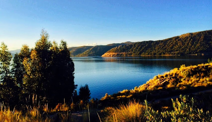
Adventure Travel

Ultimate Great Barrier Reef Snorkeling, Tours & Scuba Diving Guide — Costs, Best Times, Safety & Facts

Picture this: you’re floating above a kaleidoscope of coral gardens, schools of rainbow-colored fish dart around you, and a sea turtle glides past like it’s the most natural thing in the world. That’s what experiencing great barrier reef snorkeling feels like — and trust me, after 20 years of sending travelers to every corner of Australia, I can tell you this is one place that actually lives up to the hype. I’m Wahid Ali, and I’ve been in the tourism game long enough to know when a destination delivers and when it disappoints. The Great Barrier Reef delivers. Every single time. Whether you’re planning your first underwater adventure with great barrier reef tours or you’re a seasoned diver ready for some world-class great barrier reef scuba diving, this guide will walk you through everything you need to know — the real costs, the best times to visit, safety tips that actually matter, and great barrier reef facts that go beyond the tourist brochures. In my years heading operations at Astamb Holidays in Mumbai, I’ve seen countless clients return from the reef with stories that give me goosebumps. But I’ve also seen travelers make rookie mistakes that cost them time, money, and memories. Let’s make sure you’re in the first group. 🌊 What Is the Great Barrier Reef? Quick Facts You Must Know The Great Barrier Reef is the world’s largest living structure, spanning 2,300 kilometers (1,400 miles) along Queensland’s northeast coast and covering 344,000 square kilometers — that’s roughly the size of Italy or Japan. Let me break down what makes this place so extraordinary: Location: Off the coast of Queensland, Australia, stretching from the northern tip near Cape York down to Bundaberg in the south. Size and Scale: We’re talking about 2,900 individual reefs and over 900 islands. It’s so massive you can see it from space — literally the only living structure visible from orbit. Biodiversity: The reef is home to over 1,500 species of fish, 400 types of coral, 4,000 types of mollusks, and 240 species of birds. You’ll find six of the world’s seven species of marine turtle here, plus dolphins, whales, sharks, and the stunning manta rays. UNESCO World Heritage Status: Listed since 1981 as a World Heritage Site, the reef is protected by the Great Barrier Reef Marine Park Authority (GBRMPA), which manages this incredible ecosystem. Current Environmental Status: I won’t sugarcoat it — the reef has faced six mass bleaching events since 2016, including back-to-back events in 2024 and 2025. However, coral cover remains near its long-term average due to recovery periods between events. The reef is resilient but facing real challenges from climate change. Quick Reef Facts Details Total Length 2,300 km (1,400 miles) Total Area 344,000 sq km (133,000 sq miles) Number of Reefs 2,900+ individual reefs Number of Islands 900+ islands Fish Species 1,500+ species Coral Types 400+ hard and soft coral species UNESCO Status World Heritage Site since 1981 Water Temperature 23°C-29°C (73°F-84°F) year-round Source: Great Barrier Reef Marine Park Authority 🤿 Great Barrier Reef Snorkeling: Experience, Tips & Spots Let me paint you a picture from my client feedback: you slip into the warm water, adjust your mask, and suddenly you’re in a completely different world. The water is so clear you can see 15-30 meters ahead on a good day. Below you, coral formations create underwater cities where fish communities go about their daily business. What Snorkeling the Reef Actually Feels Like: The first breath through your snorkel feels strange if you’re new to this, but within minutes, you’ll forget you’re breathing through a tube. The water temperature averages 24°C-28°C (75°F-82°F) depending on the season — warm enough that you won’t freeze but cool enough to be refreshing. You’ll float effortlessly thanks to your life vest, and that’s when the magic happens. Best Snorkeling Spots on the Great Barrier Reef: Based on years of client experiences and operator feedback, here are the top locations: 1. Agincourt Reef (Port Douglas) ⭐⭐⭐⭐⭐ Image Source: https://www.queensland.com/in/en/home 2. Moore Reef (Cairns) ⭐⭐⭐⭐⭐ Image Source: https://cairns-tours.com/ 3. Norman Reef (Cairns) ⭐⭐⭐⭐⭐ Image Source: https://cairns-tours.com/ 4. Flynn Reef (Cairns) ⭐⭐⭐⭐ Image Source: https://cairns-tours.com/ Essential Snorkeling Gear (Usually Provided): Pro Tips from 20 Years of Experience: 🚢 Great Barrier Reef Tours: How to Choose the Best One This is where travelers get overwhelmed — there are literally hundreds of tour operators between Cairns and Port Douglas. Here’s how to cut through the noise and find your perfect reef experience. Understanding Reef Tour Types: 1. Day Tours to Outer Reef (Most Popular) 2. Pontoon Platform Tours 3. Small Group Tours 4. Liveaboard Tours (Overnight) Cairns vs. Port Douglas Departures: Factor Cairns Port Douglas Tour Options 50+ operators 15+ operators Travel Time to Outer Reef 60-90 minutes 90 minutes Reef Sites Norman, Flynn, Moore, Hastings Agincourt, Opal, Low Isles Crowd Level Higher (busier season) Lower (more exclusive feel) Price Range $179-$325 AUD $260-$410 AUD Departure Vibe Busy marina, big city energy Relaxed tropical village Best For More options, budget-friendly Quieter experience, premium feel Outer Reef vs. Inner Reef — What’s the Difference? Outer Reef: Inner Reef & Islands: What’s Actually Included in Most Tours: What Costs Extra: 🤿 Great Barrier Reef Scuba Diving Options for All Levels Here’s where it gets really exciting. If snorkeling is watching a movie on your phone, scuba diving the Great Barrier Reef is watching it in IMAX 3D. You’re not just looking down at the reef — you’re in it, moving through it, breathing underwater while fish swim inches from your face. Introductory Dives (No Experience Needed): What it involves: You’ll get a 30-minute briefing on boat, practice in shallow water or on the platform, then descend with an instructor holding your hand (literally). The instructor controls everything — you just breathe and enjoy. It’s called a “Discover Scuba Dive” or “Resort Dive.” Who it’s perfect for: Anyone nervous about diving but wanting to try. You’ll be amazed at how natural breathing underwater feels after the first few breaths.

Ultimate Great Barrier Reef Snorkeling, Tours & Scuba Diving Guide — Costs, Best Times, Safety & Facts Read More »

Uluru-Kata Tjuta National Park — Complete Travel Guide 2026

Standing at the edge of Australia’s Red Centre, watching the sunrise paint Uluru-Kata Tjuta National Park in shades of crimson and gold, I’m reminded why this place captivates millions. As someone who manages travel operations and has organized countless tours to this World Heritage-listed park, I can tell you that Uluru-Kata Tjuta National Park offers more than stunning photos – it delivers a soul-stirring connection to ancient Anangu culture and landscapes that have existed for millennia. Here’s the thing: planning a trip to Uluru-Kata Tjuta National Park requires more than just booking flights. You need insider knowledge about entry fees, the best walking trails, cultural sensitivities, and practical logistics. After years of helping travelers experience the Red Centre properly, I’ve put together everything you need to know for an unforgettable 2026 visit. What Is Uluru-Kata Tjuta National Park? 🏜️ Located in Australia’s Northern Territory, approximately 450 kilometers southwest of Alice Springs, Uluru-Kata Tjuta National Park is a dual-listed UNESCO World Heritage site recognized for both its outstanding natural and cultural values. This designation – one of only a handful worldwide – honors the park’s geological significance and its deep spiritual importance to the Anangu people, who have been the traditional custodians of this land for over 30,000 years. The park spans 1,325 square kilometers of red desert, home to two of Australia’s most iconic natural landmarks: Uluru (the massive sandstone monolith) and Kata Tjuta (a collection of 36 weathered rock domes). Park Feature Details Size 1,325 square kilometers Nearest Town Yulara (18 km from Uluru) Climate Type Semi-arid desert UNESCO Status Dual-listed (1987 for natural, 1994 for cultural) Traditional Owners Anangu (Pitjantjatjara and Yankunytjatjara people) Elevation – Uluru 348 meters above ground Elevation – Kata Tjuta 546 meters above ground (tallest dome) Annual Visitors Approximately 250,000+ The park operates under joint management between Parks Australia and the Anangu traditional owners – a model that has set international standards for indigenous land management since the historic 1985 Handback, when the Australian Government returned ownership to its rightful custodians. Uluru vs Kata Tjuta — Are They the Same Thing? This is one of the most common questions I get from travelers. While both are part of the same national park, Uluru and Kata Tjuta are distinctly different geological formations with their own unique characteristics. Uluru is a single massive sandstone monolith – essentially one enormous rock rising 348 meters above the desert floor with a circumference of 9.4 kilometers. What you see is actually just the tip; geologists estimate that most of Uluru extends several kilometers underground. The rock is approximately 550 million years old and was formed through the compression of ancient sand dunes. Kata Tjuta, whose name means “many heads” in the local Anangu language, consists of 36 separate dome formations spread across more than 20 square kilometers. The tallest dome, Mount Olga, rises 546 meters – actually 200 meters higher than Uluru. These domes are made of conglomerate rock (a mixture of boulders, pebbles, and sand cemented together) and are estimated to be around 500 million years old. Think of it this way: Uluru is like a single, smooth cathedral dome, while Kata Tjuta is a cluster of weathered, rounded peaks that create mysterious valleys and gorges between them. Why Is Uluru-Kata Tjuta National Park So Famous? 🌟 Beyond the obvious visual drama, Uluru-Kata Tjuta National Park holds profound significance that transcends typical tourist attractions. In my experience planning tours, understanding this “why” transforms a simple sightseeing trip into a meaningful journey. Geological Wonder: These formations represent one of Earth’s most remarkable geological stories. The sandstone of Uluru contains minerals that oxidize (rust) when exposed to air, creating that famous red color. At sunrise and sunset, the changing angle of sunlight amplifies different mineral compositions, making the rock appear to glow in shades ranging from deep purple to brilliant orange-red. Spiritual Heart: For the Anangu people, this landscape embodies Tjukurpa – their traditional law, culture, and creation stories. Tjukurpa explains how ancestral beings shaped the land, created the waterholes, and established the laws that govern Anangu life. Every cave, waterhole, and rock formation has stories attached, making the entire park a living cultural textbook. According to Anangu Tjukurpa, during the creation period, ancestral beings traveled across the land, hunting, fighting, loving, and teaching. As they moved, they created the landscape features we see today. The Mala (rufous hare-wallaby) people camped at Uluru, the Kuniya (woma python) fought the Liru (poisonous snake) at Mutitjulu Waterhole, and these stories are preserved in the rock art and landscape itself. Global Icon Status: Uluru has become one of the world’s most photographed natural landmarks, featured in countless films, documentaries, and travel campaigns. It represents Australia’s ancient heart and has become a pilgrimage site for travelers seeking connection with nature and indigenous culture. Scientific Importance: The park protects rare desert ecosystems, including over 400 plant species and numerous threatened animals like the Great Desert Skink and Mulgara. The joint management model has pioneered fire management techniques that balance traditional Anangu burning practices with modern conservation science. Visitor Planning Essentials (Logistics Focus) 📋 Let me share the practical details that can make or break your visit. As someone who coordinates logistics daily, I know these specifics matter. Uluru-Kata Tjuta National Park Entry Fee 💰 All visitors require a park pass to enter Uluru-Kata Tjuta National Park. Here’s what you need to know for 2026: Pass Details: How to Purchase: Where Money Goes: This is important to understand. 100% of park pass revenue is reinvested directly into: You cannot use a Northern Territory parks pass here – Uluru-Kata Tjuta National Park is federally managed by Parks Australia, requiring its own separate pass. Uluru-Kata Tjuta National Park Opening Hours ⏰ The park operates year-round with seasonal hour variations: Season Opening Hours Note December-February (Summer) 5:00 AM – 9:00 PM Extremely hot; walks close early March-May (Autumn) 5:00 AM – 8:00 PM Ideal conditions June-August (Winter) 6:30 AM – 7:30 PM Cold nights, perfect days September-November (Spring)

Uluru-Kata Tjuta National Park — Complete Travel Guide 2026 Read More »

Things to Do in Margaret River: The Ultimate Guide to Attractions, Activities & Travel Tips (2026)

Picture this: You’re standing on a limestone cliff 270 kilometers south of Perth, watching world-class surfers carve through crystal-clear Indian Ocean waves while vineyards stretch behind you into ancient karri forests. This isn’t a dream—it’s Margaret River, and in 2026, it’s calling your name with more incredible experiences than ever before. As someone who’s been managing tours in Australia’s South West for 20 years, I can tell you that things to do in Margaret River extend far beyond the postcard-perfect scenery. From exploring 100+ underground limestone caves formed over 1 million years ago to tasting world-renowned wines at 90+ cellar doors, this region delivers the perfect blend of adventure, luxury, and natural wonder. Whether you’re planning to walk the legendary 135-kilometer Cape to Cape Track, dive into ancient caves like Lake Cave and Mammoth Cave, or simply sip Chardonnay while watching the sunset over Sugarloaf Rock, Margaret River offers something extraordinary for every traveler. Things to Do in Margaret River include exploring 90+ world-class wineries, surfing at legendary breaks like Prevelly Beach, discovering ancient limestone caves (Lake Cave, Mammoth Cave, Jewel Cave), hiking the 135km Cape to Cape Track, visiting the Boranup Karri Forest, and experiencing Wadandi Aboriginal culture through guided tours. The region combines premium wine tasting, spectacular coastal scenery, adventure activities, and fresh gourmet produce into one unforgettable destination. This 2026 guide is backed by the latest information, current costs, hidden gems I’ve discovered while operating tours here, and insider secrets that’ll help you experience Margaret River like a local—not a tourist. 🍷 Why Is Margaret River So Famous? When people ask me what makes Margaret River special, I tell them about the “Triple Threat” that put this region on the world map. World-Class Wine That Rivals Bordeaux Margaret River produces less than 3% of Australia’s total wine output but accounts for over 20% of the country’s premium wine market. That’s incredible! The region’s 138+ wineries specialize in Cabernet Sauvignon and Chardonnay, with over 65 wineries rated 5-star by Halliday Wine Companion. In my experience managing wine tours, I’ve seen firsthand how the Mediterranean climate, ocean breezes from the Indian Ocean, and unique terracotta soils create perfect conditions for grape growing. Founding wineries like Vasse Felix (established 1967), Leeuwin Estate, and Cullen Wines (Australia’s first 100% carbon-neutral winery) set the standard. Today, boutique producers like Passel Estate, Victory Point, and Cape Naturaliste Vineyard offer intimate tastings where you’ll often meet the winemakers themselves. Legendary Surf That Draws World Champions Before Margaret River became famous for wine, surfers discovered its 75+ world-class breaks spanning 130 kilometers of coastline. The Margaret River Pro (held annually in April/May) attracts top World Surf League competitors to Surfers Point (Main Break) in Prevelly—one of the most challenging waves in competitive surfing. Popular breaks include: Ancient Caves Holding Earth’s Secrets Beneath the Leeuwin-Naturaliste Ridge lie over 150 limestone caves formed approximately 1 million years ago. Four spectacular “show caves” are open to the public: Indigenous Wadandi Culture & Deep Connection to Country For over 60,000 years, the Wadandi (Saltwater) people have been the traditional custodians of this land, known as Wadandi Boodja. Their cultural knowledge runs incredibly deep, with six seasonal calendars (Birak, Bunuru, Djeran, Makuru, Djilba, and Kambarang) still used today to live in harmony with the land. I highly recommend booking a Koomal Dreaming tour with Wadandi custodian Josh ‘Koomal’ Whiteland, who shares stories, traditional practices, and the significance of sites like Ngilgi Cave in Wadandi culture. These experiences add profound depth to your understanding of the region’s natural and cultural heritage. For more details: https://saltwaterbusselton.com.au/ 🌤️ Best Time to Visit Margaret River (2026 Seasonal Guide) Margaret River is beautiful year-round, but timing your visit right can save you money and help you avoid crowds. Here’s my breakdown based on 20 years of operating tours here: Season Months Temperature Crowd Level Price Range Best For What to Pack Summer (Peak) Dec–Mar 22°C–30°C (72°F–86°F) HIGH $$$$ Beach activities, swimming, festivals Sunscreen (SPF 30+), swimwear, hat, light clothing Autumn Apr–May 12°C–24°C (54°F–75°F) MEDIUM $$$ Wine tasting, Margaret River Pro surfing competition, harvest season Layers, light jacket, sunglasses Winter (Off-peak) Jun–Aug 8°C–18°C (46°F–64°F) LOW $$ Whale watching, cozy winery visits, best value Warm jacket, rain gear, hiking boots Spring (Ideal) Sep–Nov 9°C–24°C (48°F–75°F) MEDIUM $$$ Wildflowers, whale watching, perfect hiking weather Layers, rain jacket, camera, binoculars Pro Insider Tips: 2026 Special Events: 🚗 How Long Does It Take to Drive From Perth to Margaret River? The drive from Perth to Margaret River is one of Western Australia’s most scenic road trips—and one I’ve done countless times organizing tours. Distance: 270–280 kilometers (168–174 miles)Drive Time: 3–3.5 hours without stopsRoute: Take Kwinana Freeway → Forrest Highway → Bussell Highway into Margaret River The journey is straightforward on fully sealed roads, making it perfect for a long weekend getaway or the start of a longer South West adventure. 3 Must-Stop Spots on the Drive 🛑 From my experience managing transfers and tours, these three stops will break up your journey perfectly: 1. Busselton Jetty (2 hours 20 minutes from Perth)The longest timber-piled jetty in the Southern Hemisphere at 1.8 kilometers! Walk the jetty for free or take the train to the end ($14 adults, $7 children). The Underwater Observatory at the jetty’s end offers incredible views of marine life without getting wet ($35 adults, $17 children). 2. Bunbury Dolphin Discovery Centre (1.5 hours from Perth)Spot wild bottlenose dolphins from the beach or jetty. The Discovery Centre offers interactive exhibits ($15 adults, $8 children). If you’re lucky, dolphins swim right up to the shore! 3. Vineyard 28 in Yarloop (1.5 hours from Perth)A hidden gem! This boutique winery specializes in Italian grape varieties like Pignoletto, Arneis, Dolcetto, and Nebbiolo—rare finds in Western Australia. Perfect for a mid-journey wine tasting and grazing board. Bonus Stop: Lake Clifton Thrombolites—ancient living fossils lining the lake shore, resembling Earth’s earliest life forms. A fascinating 5-minute stop with a boardwalk for easy viewing. 🏖️ Top Things to Do in Margaret River, Western Australia

Things to Do in Margaret River: The Ultimate Guide to Attractions, Activities & Travel Tips (2026) Read More »

What to Do in Damaraland — Complete Travel Guide for First-Timers

Picture this: you’re standing in a landscape that feels like Mars decided to host an African wildlife show. The ground beneath your feet is 260 million years old, ancient rock art covers canyon walls, and somewhere in the distance, a family of elephants navigates the desert like they own the place (spoiler: they do). Welcome to Damaraland, where nature wrote its most dramatic script and forgot to add any other tourists to the scene. If you’re wondering what to do in Damaraland, you’ve landed in the right corner of the internet. This isn’t your standard safari destination with paved roads and gift shops. Damaraland is raw, remote, and ridiculously beautiful—a place where geological wonders meet prehistoric art and wildlife that shouldn’t survive here somehow thrives. Located in Namibia’s rugged Kunene Region, Damaraland stretches across roughly 42,000 square kilometers of rock formations, dry riverbeds, and stark desert beauty. This isn’t a place you’ll stumble upon by accident. It takes effort to reach, but that’s exactly what keeps it special. You won’t find safari traffic jams here—just you, the landscape, and animals that adapted to survive where others couldn’t. This guide breaks down everything you need to know: the ancient rock engravings that’ll make you rethink human history, the wildlife that defies desert logic, the geological formations that look computer-generated but are entirely natural, and the practical stuff like when to visit and whether you actually need that 4×4 everyone keeps talking about. Quick Reference: Damaraland Travel Essentials Essential Info Details Location Kunene Region, northwestern Namibia Best Time to Visit May to October (dry season) Must-See Attractions Twyfelfontein rock art, desert elephants, Brandberg Mountain Wildlife Highlights Desert-adapted elephants, black rhino, oryx, mountain zebra Recommended Duration 3-4 days for full experience Getting There Self-drive from Windhoek (5-6 hours) or fly to Palmwag Vehicle Needed 4×4 recommended for most areas Accommodation Types Eco-lodges, tented camps, camping sites Average Daily Budget $80-250 USD (mid-range) Terrain Type Rocky desert, gravel roads, mountain passes Best Time to Visit & How to Reach Damaraland Timing can make or break your Damaraland adventure, and getting there requires a bit more planning than booking a flight to a beach resort. When Should You Go? The best time to visit Damaraland runs from May through October during Namibia’s dry season. Here’s why these months work so well: Dry Season (May-October): Temperatures hover between 20-25°C (68-77°F) during the day, dropping to 5-10°C (41-50°F) at night. Wildlife congregates around permanent water sources, making animal spotting significantly easier. The roads are in better condition, and you won’t need to worry about flash floods blocking your route. According to the Namibia Tourism Board, this period sees the clearest skies for stargazing—a legitimate highlight in this low-light-pollution zone. Green Season (November-April): Summer brings occasional rains, temperatures climbing to 35°C (95°F), and vegetation that transforms the landscape into something greener but less Mars-like. Wildlife disperses as water becomes available everywhere. Roads can become challenging, sometimes impassable. However, if you’re a photographer chasing dramatic storm clouds over red rocks, this season delivers. January through March is particularly hot and humid. Unless you enjoy feeling like you’re hiking inside a hair dryer, save these months for somewhere with air conditioning. Getting to Damaraland By Air: Fly into Windhoek’s Hosea Kutako International Airport. From there, you can take a chartered flight to smaller airstrips near Palmwag or Damaraland Camp (if your accommodation arranges it), or drive. Some visitors fly into Walvis Bay and drive north. By Road: Most people self-drive from Windhoek, which takes 5-6 hours covering roughly 350-400 kilometers depending on your exact destination. The C39 and C43 gravel roads are your main arteries through the region. These aren’t highways—expect washboard surfaces, occasional sharp rocks, and the need to drop your speed significantly. Vehicle Requirements: Here’s the honest answer about the 4×4 question: you can reach some main attractions like Twyfelfontein with a high-clearance 2WD sedan, but a 4×4 opens up significantly more territory. For wildlife tracking, visiting the Petrified Forest, or accessing remote camps, you’ll want four-wheel drive. Rental costs in Namibia run $50-120 USD daily for 4x4s depending on the season and vehicle type. Guided Tours vs Self-Drive: Self-driving gives you freedom and flexibility. Guided tours provide expert wildlife tracking and cultural context you’d otherwise miss. Companies like Wilderness Safaris and Natural Selection operate excellent guided experiences through the region. Budget $300-500 USD per person daily for full-service guided tours. 🎨 Top Must-See Attractions: Rock Art & Geological Wonders Damaraland’s attractions read like someone challenged nature to show off. Between UNESCO World Heritage rock art and geological formations that science teachers use as textbook examples, you’ll need more memory cards than you packed. Twyfelfontein Rock Engravings Twyfelfontein holds Africa’s largest concentration of rock petroglyphs and paintings, with over 2,500 individual works created by San hunter-gatherers roughly 6,000 years ago. UNESCO declared it a World Heritage Site in 2007, and standing among these ancient artworks feels like reading humanity’s first travel blog. The engravings cover hunting scenes, animal tracks, and geometric patterns etched into sandstone slabs. You’ll spot giraffes, elephants, ostriches, and the famous “swimming lion”—though why ancient artists depicted a lion swimming in a desert remains delightfully mysterious. Visiting Tips: You must join a guided walk (required by law to protect the site). Tours cost approximately $10-15 USD per person and last 45-60 minutes. Mornings before 10 AM offer the best light for photography and cooler temperatures. The site has basic facilities but no restaurant, so bring water and snacks. Brandberg Mountain & The White Lady Painting Brandberg Massif rises 2,573 meters above sea level, making it Namibia’s highest peak. The granite mountain glows orange-red at sunrise—hence “Brandberg” (Fire Mountain). Hidden in a gorge on its slopes sits the famous White Lady rock painting, discovered in 1918 by German surveyor Reinhard Maack. Despite the name, the figure probably isn’t female or white—it’s likely a San shaman painted with white clay as part of a ceremonial scene. The painting dates back roughly 2,000 years and remains remarkably

What to Do in Damaraland — Complete Travel Guide for First-Timers Read More »

Why Is Madidi National Park Dangerous? Risks, Reality & Safety Guide for Jungle Travelers

If you’ve been researching why is Madidi National Park dangerous, you’re already showing the kind of smart caution that keeps jungle travelers safe. Madidi National Park in Bolivia is one of Earth’s most biodiverse protected areas, home to over 1,000 bird species, jaguars, giant otters, and ecosystems that shift from steaming Amazon lowlands to icy Andean peaks. But this remarkable wilderness comes with serious risks that demand respect, preparation, and honest conversation. This guide breaks down the real dangers—from venomous wildlife and jungle diseases to accessibility challenges and human threats—while showing you how to experience Madidi responsibly and safely. Table of Contents Section Key Topics Covered Quick Risk Summary Wildlife, health, accessibility, environmental, human threats Geographic Complexity Altitude variation, climate zones, terrain challenges Wild Animals & Jungle Hazards Jaguars, poison dart frogs, venomous snakes, fire ants Health Risks & Diseases Malaria, yellow fever, parasites, medical evacuation Accessibility & Remoteness Transport difficulties, communication gaps, guide necessity Human & Environmental Threats Dam projects, illegal mining, logging, mercury contamination Real Stories & Case Studies Yossi Ghinsberg survival story, documented incidents Risk Timing & Zones Seasonal differences, terrain variations, traveler types Safety Tips Vaccinations, gear, insurance, choosing operators Conservation Ethics Indigenous communities, responsible tourism impact Comparison with Other Parks How Madidi stacks up against Tambopata, Manu FAQs Quick answers to common safety questions Quick Risk Summary — What Makes Madidi Dangerous (At a Glance) Let’s start with clarity. Madidi National Park safety risks fall into five main categories: Wildlife Hazards: Jaguars, pumas, venomous snakes (including fer-de-lance and bushmaster), poison dart frogs, fire ants, caimans, and stingrays inhabit the park. Most wildlife avoids humans, but encounters happen in low-visibility jungle conditions. Health Threats: Malaria and yellow fever are present. Waterborne parasites, dengue, and leishmaniasis pose additional risks. Medical facilities are hours or days away from most park areas. Environmental Extremes: Altitude ranges from 200 meters in the Amazon lowlands to nearly 6,000 meters in the Andean highlands create unpredictable weather, flash floods during rainy season, and challenging terrain. Accessibility Challenges: No roads penetrate most of the park. River transport from Rurrenabaque takes 3-6 hours minimum. Zero mobile phone or internet coverage exists in the interior. Evacuation requires boat travel followed by small aircraft. Human-Driven Dangers: The proposed Bala Dam project threatens flooding, illegal gold mining contaminates water with mercury, and logging operations create conflict zones near park boundaries. Understanding these risks doesn’t mean avoiding Madidi—it means approaching this extraordinary place with the preparation it deserves. Geographic & Environmental Complexity of Madidi — From Andes to Amazon 🏔️ Here’s what makes Madidi National Park’s geography so challenging: this isn’t your typical jungle. The park spans an extraordinary elevation range from 180-200 meters above sea level in the steaming Amazon lowlands to nearly 6,000 meters in the glacier-covered peaks of the Apolobamba Range. That’s a height difference equivalent to climbing from sea level almost to the summit of Mount Kilimanjaro—all within one protected area. This dramatic altitude variation between the Andes and Amazon creates multiple climate zones stacked on top of each other. The climate shifts from cold alpine conditions at high elevations to moderate temperatures at mid-levels and tropical heat in the northern lowlands. You could start your morning needing a winter jacket in cloud forest and finish the afternoon dripping sweat in humid rainforest. The park protects several distinct ecosystems: tropical rainforest along the Tuichi and Beni Rivers, cloud forests clinging to mountain slopes, Yungas subtropical forests bridging the Andes and lowlands, and even montane dry forests where grasslands meet scrubland [Source: Wildlife Conservation Society / Madidi National Park Documentation]. Each ecosystem brings its own hazards—flash floods in lowland areas, altitude sickness and cold exposure in highlands, and reduced visibility in dense cloud forest. Annual precipitation averages around 716mm in some areas but can reach 4,000mm in others, creating unpredictable micro-climates. The rainy season from October to March transforms rivers into raging torrents, while the dry season from May to September makes wildlife viewing easier but doesn’t eliminate danger. Cold fronts called “surazos” occasionally sweep up from the south during June-July, dropping temperatures from 25-33°C to as low as 7-10°C in the lowlands—a potentially deadly temperature swing if you’re unprepared. The terrain complexity adds another layer of risk. Steep slopes, meandering rivers, swamps, and dense jungle create navigation challenges even for experienced guides. There are no roads penetrating the interior—only river routes that can take 3-6 hours by motorboat from Rurrenabaque just to reach the park entrance [Source: Madidi Ecolodge / National Park Access Documentation]. This geographic diversity is precisely what makes Madidi the world’s most biodiverse national park, but it also means you’re dealing with multiple environments, each demanding different safety protocols and gear. Wild Animals, Poisonous Species & Jungle Hazards 🐆 Let’s talk about the real wildlife threats in Madidi rainforest. The danger isn’t usually what Hollywood shows you—it’s what you don’t see coming. Jaguars and Pumas: Stealth Predators Madidi is home to jaguars, pumas, sloths, and spectacled bears among its 272 recorded mammal species Andean Trails. Jaguar attacks on humans are rare, with experts citing jaguars as the least likely of all big cats to kill and eat humans Wikipedia. Most attacks happen when the animal is cornered or wounded. However, attacks by jaguars in Amazon regions, while less frequent than those from pumas or other big cats, are more common than previously recognized and demonstrate a real risk in certain areas Sage JournalsResearchGate. The real danger isn’t aggression—it’s visibility. Jaguars are ambush predators that wait in cover, often attacking from trees and blind spots. In Madidi’s dense jungle where visibility drops to mere feet, you could pass within meters of a jaguar and never know it. Pumas pose similar stealth risks. Jaguars are notoriously secretive creatures that avoid humans, with attacks being extremely rare Panthera, but the keyword is “avoid”—not “don’t exist in the same space.” When trails cut through hunting territory, encounters become possible. The Truth About Poison Dart Frogs The poison dart frog in Madidi gets sensationalized, but

Why Is Madidi National Park Dangerous? Risks, Reality & Safety Guide for Jungle Travelers Read More »

Providencia Island Colombia: The Hidden Caribbean Gem You Must Visit in 2026

Forget the crowded beaches of Cartagena and the party scene of San Andrés. If you’re searching for an authentic Caribbean paradise that feels like stepping back in time, Providencia Island Colombia is your answer. This tiny volcanic island, rising from the turquoise waters off Colombia’s Caribbean coast, offers something most tropical destinations have lost: genuine tranquility, untouched natural beauty, and a culture that hasn’t been diluted by mass tourism. Picture this: you’re standing on a beach so secluded you can count the other visitors on one hand, gazing out at what locals call the sea of seven colours—layers of turquoise, emerald, sapphire, and aquamarine stretching toward the horizon. The warm Caribbean breeze carries the scent of salt air mixed with coconut bread baking in a nearby Raizal family’s kitchen. A parrot calls from the hillside while fishing boats painted in bright colors bob gently in the protected lagoon. This isn’t a postcard or a dream—this is daily life on Providencia Island. Quick Reference Guide to Providencia Island Essential Information Details Location Caribbean Sea, 775 km northwest of mainland Colombia Size Approximately 17 km² (6.5 square miles) Population Around 5,000 residents (predominantly Raizal people) Language Spanish and San Andrés-Providencia Creole (English-based) Currency Colombian Peso (COP) Best Time to Visit December to April (dry season) How to Get There Flight from mainland Colombia to San Andrés, then small plane or ferry to Providencia Airport El Embrujo Airport (PVA) UNESCO Status Part of Seaflower Biosphere Reserve Major Natural Park Old Providence McBean Lagoon National Natural Park Connected Island Santa Catalina Island (via pedestrian bridge) Average Daily Budget $50-100 USD (budget to mid-range) Accommodation Type Posadas (guesthouses), beach huts, small hotels Must-Try Food Rondón (seafood stew), pan de coco (coconut bread) Top Activity Snorkeling at Crab Cay (Cayo Cangrejo) Important Note Recovery ongoing from Hurricane Iota (2020)—verify current conditions What Is Providencia Island — Geography, People & Culture 🏝️ Providencia Island is a mountainous volcanic island that rises dramatically from the Caribbean Sea, its highest point—The Peak—reaching 360 meters (1,180 feet) above sea level. Connected to the smaller Santa Catalina Island by a charming pedestrian bridge called the Bridge of Love, Providencia feels worlds away from the hustle of modern life, despite being part of Colombia. The Raizal People: Guardians of Island Culture What truly sets Providencia apart isn’t just its natural beauty—it’s the Raizal people, an Afro-Caribbean community with roots dating back to English, Scottish, and African settlers from the 17th century. The Raizals speak San Andrés-Providencia Creole, an English-based Creole language that sounds like a melodic blend of Caribbean English, Spanish, and African linguistic influences. When you hear locals chatting in Creole while repairing fishing nets or selling fresh catch at the market, you’re experiencing a living cultural treasure. The island’s history is a fascinating tapestry woven from English colonization (it was under British rule until 1822), Spanish control, pirate legends (yes, Henry Morgan supposedly hid treasure here!), and African heritage. This unique blend created a culture that feels distinctly Caribbean rather than typically Colombian—more reggae than reggaeton, more cricket than soccer, more fish stew than arepas. The laid-back lifestyle here isn’t a marketing slogan—it’s a way of life. Island time means something on Providencia. Shops might close for an afternoon siesta, locals stop to chat for twenty minutes, and rushing is simply not part of the vocabulary. This slower pace is part of what makes the island so special for travelers seeking authentic experiences. Natural Beauty & Ecosystem — What Makes It Special 🌊 The Seven-Colours Sea: Nature’s Watercolor Masterpiece The seven-coloured sea surrounding Providencia isn’t just beautiful—it’s otherworldly. As you approach the island by plane, looking down feels like gazing at an artist’s palette where someone mixed every shade of blue and green imaginable. The phenomenon occurs due to varying depths of crystal-clear water over white sand and coral formations, creating distinct bands of color: deep navy in the channels, brilliant turquoise over shallow reefs, emerald green in the lagoons, and pale aquamarine near shore. This isn’t exaggeration or Instagram filters—the sea of seven colours is genuinely visible to the naked eye, especially on sunny days when the light penetrates the water. Scientists have identified at least seven distinct color zones, though locals joke you can see more if you look closely enough. A Marine Sanctuary of Global Importance Providencia sits within the Seaflower Biosphere Reserve, a UNESCO-designated area covering 65,000 km² of marine and coastal ecosystems—one of the largest marine protected areas in the Caribbean. The reserve earned this prestigious status in 2000 due to its exceptional biodiversity and the intact nature of its ecosystems. The island is surrounded by the third-largest barrier coral reef in the world, stretching approximately 32 kilometers (20 miles) and creating a natural breakwater that keeps the inner waters calm and protected. This massive reef system is home to the Old Providence McBean Lagoon National Natural Park, Colombia’s only oceanic natural park, established in 1995. The marine biodiversity here rivals anything in the Caribbean. The protected waters host over 150 species of fish, including parrotfish, angelfish, groupers, and barracudas. Sea turtles (hawksbill, green, and loggerhead) nest on Providencia’s beaches and feed in the seagrass beds. Spotted eagle rays glide through the channels, nurse sharks rest in shallow waters, and if you’re exceptionally lucky, you might spot a Caribbean reef shark patrolling the outer reef. The coral reef itself is a living kaleidoscope: brain corals the size of small cars, delicate sea fans waving in the current, neon-bright sponges, and forests of elkhorn and staghorn corals that provide nurseries for juvenile fish. Marine biologists consider the Seaflower Biosphere Reserve one of the healthiest coral reef systems remaining in the Caribbean—a remarkable achievement given the widespread coral bleaching and degradation elsewhere. Top Things to Do — Beaches, Snorkeling, Hiking & Island Life ⛱️ Dive into the Seven-Colours Sea: Underwater Paradise If you only do one thing on Providencia Island, make it exploring the underwater world. This is genuinely world-class snorkeling and diving, comparable to Belize,

Providencia Island Colombia: The Hidden Caribbean Gem You Must Visit in 2026 Read More »

Samaipata Bolivia Things to Do: Complete Travel Guide 2025–2026 (History, Nature, Local Gems & Insider Tips)

You know that feeling when you stumble into a place that just gets you? That’s Samaipata. This little mountain town sits right where the Andes decide to kiss the Amazon jungle, and honestly, it’s one of those places you plan to stay for two days and end up camping out for a week. If you’re searching for authentic Samaipata Bolivia things to do that go beyond the typical tourist circus, you’ve landed in the right place. No crowds fighting for selfie spots. No aggressive tour hawkers. Just crisp mountain air, ancient rock carvings, waterfalls cold enough to make you yelp, and a vibe that’s equal parts backpacker chill and Bolivian authenticity. Here’s the thing: Samaipata isn’t trying to impress anyone. The town square has more dogs napping in the sun than cars. The expat community runs cute cafés where you can get decent espresso (a miracle in rural Bolivia). And when you want adventure? You’re literally surrounded by cloud forests, pre-Inca ruins, and swimming holes that feel like your own private discovery. This guide covers everything you need: how to actually get there (the shared taxi situation is real), when to visit without getting soaked, the history behind those massive rock carvings, nature trails that’ll make your Instagram followers jealous, and the kind of insider tips that only come from spending real time in a place. Whether you’ve got three days or a full week, I’ll break down exactly how to experience Samaipata the right way. How to Get to Samaipata & When to Visit Getting There: The Shared Taxi Dance Samaipata sits about 120 kilometers southwest of Santa Cruz de la Sierra, Bolivia’s biggest city. Forget buses if you value your sanity and lower back. The move here is taking a “truffi” – these shared taxis that leave when they’re full (which is very Bolivian, very unpredictable, and somehow always works out). Head to the corner of Avenida Omar Chávez and Soliz de Olguín in Santa Cruz. Look for the cluster of white vans with drivers yelling “¡Samaipata! ¡Samaipata!” You’ll pay around 30-40 Bolivianos (about $4-6 USD). The ride takes 2.5 to 3 hours depending on whether your driver thinks he’s auditioning for Fast & Furious or actually respects the curves. The scenery shifts dramatically – you start in tropical lowlands and climb into pine-covered mountains. Crack a window and smell that change in the air. Pro tip: Truffis leave throughout the morning, but the sweet spot is 8-10 AM. Go too late and you might wait around. Too early and, well, nothing in Bolivia really starts before 8 AM anyway. Best Time to Visit Samaipata The dry season runs from May through October, and that’s your golden window. Clear skies, minimal mud on the trails, and temperatures that hover around 20-25°C (68-77°F) during the day. Nights get chilly though – we’re talking 5-10°C (41-50°F). You’ll want layers. November through April brings the wet season. It’s not a total write-off – the waterfalls are more impressive and everything’s absurdly green – but hiking becomes a muddy wrestling match. If you’re coming for Amboró National Park, stick to dry season unless you enjoy slipping down trails. Samaipata weather is that tricky mountain situation where you can experience four seasons in one day. Morning frost, afternoon sun that burns through your sunscreen, evening chill that has you hunting for your fleece. Pack accordingly. What to Pack: The Real List Top Things to Do in Samaipata Visit El Fuerte de Samaipata — History & Archaeology Let’s clear something up first: El Fuerte de Samaipata isn’t actually a fortress. The Spanish called it that because they have no imagination. This massive carved rock – the largest of its kind in the world – was a ceremonial center used by the Chané people (pre-Inca) and later the Incas themselves. UNESCO recognized it as a World Heritage Site in 1998, which is fancy talk for “this place is legitimately important.” The site sits about 9 kilometers from town. You can walk it (uphill, allow 2+ hours), bike it (rent in town for 30-40 BOB/day), or catch a ride with a tour. Entry costs 50 Bolivianos for foreigners. What makes El Fuerte de Samaipata history fascinating is what you’re actually looking at. The massive rock face is carved with channels, seats, geometric shapes, and animal representations. The most famous is the “Cascabel” – a serpent design that winds across the stone. These weren’t random doodles. They were sacred ceremonial spaces, possibly connected to water rituals and astronomical observations. The experience hits different early morning. You get there around 8 AM and the place is yours. The light is softer. You can run your hands along those ancient grooves (carefully – erosion is real) and actually process what it took to carve this. No metal tools. Just stone on stone and an incredible amount of intention. From the upper platform, the view spreads across the Samaipata Valley toward the cloud forest. On clear days, you can see layers of mountains fading into blue distance. Bring water – there’s minimal shade – and give yourself at least 2 hours to explore properly. Important: Stay on marked paths. The rock is sandstone, which means it erodes easily. Tourism is slowly damaging the carvings, so be a conscious visitor. Explore Nature — Amboró National Park & Surrounding Trails Here’s where Samaipata gets wild. Amboró National Park protects one of the most biodiverse areas on the planet. We’re talking the exact meeting point of three ecosystems: Andes mountains, Amazon rainforest, and the Chaco. That means you can see spectacled bears, jaguars, over 800 bird species, and more insects than you can possibly identify. The park’s cloud forest section near Samaipata is absolutely otherworldly. Giant tree ferns create canopies overhead. Everything is draped in moss. The air smells like wet earth and growing things. If you’ve seen Jurassic Park, that’s the vibe – you half expect a dinosaur to crash through the foliage. Critical info: You cannot enter Amboró alone. It’s

Samaipata Bolivia Things to Do: Complete Travel Guide 2025–2026 (History, Nature, Local Gems & Insider Tips) Read More »

Vilcabamba Ecuador – The Lost City Where Longevity Meets Hidden Adventure

I still remember the first time I stepped off the bus in Vilcabamba, Ecuador – The Lost City, my lungs filling with air so crisp it felt medicinal. The emerald peaks of Mandango rose sharply against the impossibly blue Andean sky, and an elderly woman—easily in her nineties—strode past me carrying a basket of papayas without breaking stride. This wasn’t the tourist-packed Ecuador I’d expected. This was something else entirely: a place where time moved differently, where legends of people living to 120 weren’t just folklore but a tourism claim that sparked decades of scientific curiosity. Whether you’re a wellness seeker hunting for the world’s healthiest lifestyle, a hiker craving undiscovered trails, or a digital nomad searching for affordable paradise, Vilcabamba, Ecuador – The Lost City offers something rare in our hyperconnected world—a chance to truly disconnect and rediscover what living well actually means. At XploreHeaven.com, we specialize in unearthing hidden gems that most guidebooks skip over, and this sacred valley in southern Ecuador might be our most intriguing find yet. Quick Facts: About Vilcabamba, Ecuador – The Lost City at a Glance Detail Information Location Loja Province, Southern Ecuador Elevation 1,500 meters (4,921 feet) Climate Eternal Spring (15-26°C / 59-79°F year-round) Distance from Loja 45 km (28 miles), 1.5 hours by bus Distance from Quito 650 km (404 miles), 12-14 hours by bus or 1-hour flight to Loja + transfer Currency US Dollar Best Time to Visit June to September (dry season) Famous For Longevity legends, hiking, wellness retreats, expat community Primary Language Spanish (some English in expat areas) Population Approximately 5,000 (including surrounding areas) Where Is Vilcabamba Ecuador – The Lost City? Vilcabamba, Ecuador – The Lost City sits tucked away in the Loja Province, cradled between the rugged foothills of the Andes Ecuador hidden valley system. About 45 kilometers south of the colonial city of Loja, this sacred valley feels like it exists outside the normal flow of time. The name itself—derived from the Quechua word “Huillcopamba” meaning “sacred valley”—hints at the reverence indigenous communities held for this land. Getting here requires commitment, which is precisely why it remains unspoiled. From Quito, you’ll either endure a scenic but lengthy 12-14 hour bus journey through mountain passes and cloud forests, or you can fly to Loja (about an hour) and catch a local bus or taxi for the final leg. The road from Loja winds through eucalyptus groves and past small farms where horses graze freely. Cell service becomes spotty. The modern world starts to fade. The valley itself stretches along the banks of the Chamba River, surrounded by peaks that shift from green to gold depending on the season. At 1,500 meters elevation, you’re high enough to enjoy cool mountain air without the harsh altitude effects of places like Quito or Cusco. The climate here earned Vilcabamba its nickname: the land of eternal spring. Why “The Lost City”? Let me clear something up right away: Vilcabamba, Ecuador – The Lost City isn’t a ruins site like Machu Picchu or the actual Lost City (Ciudad Perdida) in Colombia. There are no ancient stone temples hidden in the jungle here. Instead, the “Lost City” moniker captures something more subtle—a sense of being forgotten by time, a place that modernity somehow overlooked. When I walked through the town square on my first evening, I understood. Old men in worn ponchos sat on benches, sharing jokes in Quechua-inflected Spanish. A farmer led his donkey down the cobblestone street. The only “chain” establishment was a single pharmacy. This wasn’t curated for Instagram—this was authentic smalltown Andean life continuing as it has for generations. The indigenous Palta people inhabited these valleys long before Spanish conquest, and their descendants still farm the surrounding hillsides. The Spanish colonizers largely bypassed Vilcabamba because it lacked precious metals and proved difficult to access. This isolation preserved traditional agricultural practices and a slower pace of life that would later attract both scientists and seekers. In the 1970s, when National Geographic and other outlets began publishing stories about the Valley of Longevity, the world suddenly took notice of this secluded paradise. Yet even today, it remains wonderfully off the beaten path—a true hidden gem for travelers willing to venture beyond the Galapagos-Quito-Cuenca circuit. The Longevity Myth & Science Here’s where things get fascinating—and where I need to separate fact from marketing hype. The Legend: Starting in the 1950s, stories emerged about residents of Vilcabamba routinely living to 120, 130, even 140 years old. Dr. Miguel Salvador of Quito reportedly found dozens of centenarians in the valley. By the 1970s, journalists and researchers flooded in, dubbing it the Valley of Longevity and comparing it to other “Blue Zones” like Okinawa and Sardinia. The Reality: Later scientific investigations—including work by Dr. Alexander Leaf from Harvard and demographic studies in the 1980s—revealed a less miraculous but still interesting truth [Link to Source: National Institutes of Health longevity studies]. Many age claims were exaggerated, often because residents lacked official birth certificates and conflated their ages with those of deceased relatives sharing the same name. The 140-year-old grandfather? Probably closer to 90. But here’s what remains true: The elderly population in Vilcabamba exhibits remarkable vitality. I met Don Miguel, who claimed to be 103 (likely closer to 85), still tending his coffee plants and walking two miles daily to visit his grandchildren. The combination of factors—clean mineral-rich water from mountain streams, an active lifestyle farming steep hillsides, a plant-based diet heavy on legumes and corn, strong social bonds, and that perfect climate—creates genuine health benefits. Modern researchers now focus on these lifestyle factors rather than record-breaking ages [Link to Source: Journal of Public Health Studies]. The longevity study Vilcabamba legacy isn’t about superhuman genetics but about how traditional mountain living naturally promotes wellness—a lesson increasingly valuable in our sedentary, processed-food world. Nature, Climate & Environment That Support Well-being The moment you arrive in Vilcabamba, you feel it—the air tastes different. Cleaner. Almost sweet. The Eternal Spring Climate delivers consistent temperatures between 15-26°C (59-79°F)

Vilcabamba Ecuador – The Lost City Where Longevity Meets Hidden Adventure Read More »

What to Do in Salta: The Ultimate 2025 Travel Guide to Salta City & Beyond

Picture this: cobblestone streets lined with colonial buildings painted in sunset colors, mountain peaks touching cotton-candy clouds, and the sound of folk guitars drifting from candlelit doorways. Welcome to Salta la Linda—Salta the Beautiful—a city that sits pretty in Argentina’s northwest corner and refuses to follow the rules of typical South American travel. Most travelers zoom straight to Patagonia or Buenos Aires, but those in the know? They head north to Salta. This isn’t just another pretty colonial city (though it absolutely is that). It’s your gateway to some of the most jaw-dropping landscapes in Argentina—think rainbow mountains, endless salt flats that mess with your sense of reality, and wine valleys tucked between red-rock canyons. This guide covers everything you need to know about what to do in Salta, from wandering the city’s historic plazas to planning epic day trips into the surrounding Andes. Whether you’re here for three days or three weeks, we’ve got the insider scoop on attractions, logistics, local experiences, and those secret spots that make travel magical. Quick Salta Travel Information Category Details Best Time to Visit April-May & September-November (shoulder seasons) Airport Code SLA (Martín Miguel de Güemes International Airport) Altitude City: 1,187m (3,894 ft) / Excursions: Up to 4,170m (13,680 ft) Recommended Stay 4-6 days (2 city + 2-4 excursions) Currency Argentine Peso (ARS) – bring USD for better exchange rates Must-Try Empanadas Salteñas, Locro stew, Torrontés wine Don’t Miss Peña folklórica show, MAAM museum, Quebrada de las Conchas Budget Range Backpacker: $30-50/day | Mid-Range: $70-120/day | Luxury: $150+/day Getting to and Getting Around Salta How to Reach Salta Flying into Salta (SLA) is your easiest bet. Direct flights connect from Buenos Aires (2-hour flight), plus seasonal connections from other Argentine cities. The airport sits about 10 kilometers from downtown, making transfers quick and painless. If you’re doing the overland adventure thing, long-distance buses run from Buenos Aires (20+ hours—not for the faint of heart), Tucumán (4 hours), and other northern cities. Argentina’s bus system is surprisingly comfortable with reclining seats and meal service, but time-wise, flying makes way more sense unless you’re on a serious budget. Getting Around: Your Options Decoded Here’s where trip planning gets interesting. Salta city attractions are totally walkable—you can cover the historic center on foot in a day. But those incredible day trips? You’ve got choices: Rental Car (Best for Freedom Seekers)Renting a car gives you complete control over your schedule. The roads around Salta are generally good, though mountain passes require confidence with switchbacks and altitude. Gas stations exist but get sparse once you head into remote areas. This works beautifully if you want to stop every five minutes for photos (and trust me, you will). Organized Tours (Best for Ease)Nearly every hotel and hostel can book you on guided day trips. You’ll share a minibus with other travelers, hit all the highlights, and learn from local guides. The downside? Fixed schedules and less flexibility. Tours typically run 12-14 hours for the full-day excursions. Public Transport (Budget Option)Buses connect Salta to major towns like Cafayate and Cachi, but they don’t stop at scenic viewpoints along the way. You’ll miss photo ops at places like Quebrada de las Conchas. Only recommended if you’re seriously stretching pesos. Our Take: First-timers and solo travelers often prefer tours for the first excursion, then rent a car if they want more freedom. Families and groups find rental cars more economical when you split costs. Weather Watch Salta enjoys sunshine about 300 days a year, but seasons matter. Summer (December-February) brings afternoon rain and higher temperatures. Winter (June-August) delivers crystal-clear skies but chilly nights—especially at altitude. The sweet spot? April-May and September-November offer comfortable temps, fewer crowds, and perfect road conditions for exploring. Top Things to Do in Salta (City) – Your 1-Day Itinerary Morning: Museum Magic at MAAM Start your day at the Museo Arqueológico de Alta Montaña (MAAM)—possibly the most fascinating museum you’ve never heard of. This isn’t your dusty artifact warehouse. MAAM houses three incredibly preserved Inca children discovered at 6,700 meters on volcanic peaks, naturally mummified by extreme cold and altitude. The museum tells their story with respect and scientific rigor, explaining Inca capacocha ceremonies and high-altitude archaeology. It’s profound, moving, and completely unique. Plan for 60-90 minutes here. Check the official MAAM website for current hours and rotating exhibits—only one child is displayed at a time to ensure preservation. Late Morning: Colonial Center Circuit From MAAM, wander over to Plaza 9 de Julio, Salta’s beating heart. This isn’t just any plaza—it’s one of Argentina’s most beautiful, surrounded by orange trees and colonial architecture that’ll have your camera working overtime. Hit these spots around the plaza: Grab lunch at one of the cafes lining the plaza. Order empanadas salteñas—these aren’t your average empanadas. Salta-style means they’re smaller, perfectly spiced with cumin, and stuffed with beef, potatoes, and hard-boiled egg. Afternoon: Rise to Cerro San Bernardo After lunch, take the teleférico (cable car) up Cerro San Bernardo for panoramic views over the entire Lerma Valley. The city spreads below you in a patchwork of terracotta roofs and green plazas, with mountains rising dramatically in every direction. Feeling energetic? Skip the cable car and hike the 1,070 steps instead. The trail winds through gardens and past stations of the cross. It takes about 45 minutes and rewards you with that smug “I earned this view” feeling. Evening: Peña Folklórica Experience Here’s where Salta really shows its personality. A peña folklórica is a folk-music dinner show, but calling it that undersells the experience. These intimate venues pulse with traditional Argentine music—zambas, chacareras, and the haunting sound of bombo drums mixed with guitars. Locals pack these places on weekends, singing along and sometimes spontaneously joining the dancing. Try La Casona del Molino or Peña Gauchos de Güemes. You’ll eat regional dishes like locro (a hearty stew), humita (corn tamales), and tamales salteños while musicians rotate through sets. Pro tip: Peñas get crowded on Friday and Saturday nights—make reservations or arrive early. The

What to Do in Salta: The Ultimate 2025 Travel Guide to Salta City & Beyond Read More »

What to See in Vengurla – Ultimate Konkan Beach Guide

Quick Vengurla Travel Information Category Details Location Sindhudurg District, Maharashtra (South Konkan Coast) Distance from Mumbai ~520 km (10-11 hours by road) Distance from Pune ~430 km (8-9 hours by road) Distance from Goa ~120 km (3 hours by road) Best Time to Visit October to March (cool and pleasant) Nearest Railway Station Kudal (12 km away) Language Spoken Marathi, Konkani, Malvani Famous For Pristine beaches, lighthouse views, Malvani cuisine Ideal Trip Duration 2-3 days Introduction Ever felt tired of fighting for a spot on crowded beaches? Sick of overpriced shacks and noisy beach parties? Then Vengurla is calling your name. Tucked away in Maharashtra’s Sindhudurg district, Vengurla is that rare Konkan treasure most travelers haven’t discovered yet. While everyone’s rushing to Goa or standing shoulder-to-shoulder at Alibaug, this quiet coastal town offers something truly special – empty white-sand beaches, crystal-clear waters, and the kind of peace that makes you forget your phone exists. This guide will walk you through everything what to see in Vengurla, from its stunning beaches and historic lighthouse to hidden coves only locals know about. Whether you’re planning a family holiday, a solo escape, or a romantic weekend, Vengurla delivers that authentic Konkan experience you’ve been searching for. Ready? Let’s explore this hidden paradise. Best Beaches When Visiting Vengurla 1. Khavane Beach – The Crown Jewel Khavane Beach is where most travelers fall in love with Vengurla. Picture this: soft white sand stretching for miles, gentle waves perfect for swimming, and barely another soul in sight. The beach curves beautifully, creating natural pools during low tide that kids absolutely love. What Makes It Special: Beach-Specific Tips: Best Time Local Food Crowd Avoidance What to Pack 6:30-8:00 AM for sunrise magic Try Bhaji-Pav and fresh coconut water from the blue cart near the entrance Visit on weekdays; weekends get busier after 10 AM Sunscreen, hat, reusable water bottle, beach mat Local Secret: Walk to the rocky section at the south end during low tide (around 4-5 PM). You’ll find tide pools filled with tiny crabs and colorful fish – perfect for photography! 2. Kondura Beach – The Adventure Spot If you’re craving some action, Kondura Beach delivers. This beach is rockier than Khavane, making it ideal for exploring tide pools and watching powerful waves crash against ancient stones. It’s less crowded and has a wilder, more rugged charm. What Makes It Special: Beach-Specific Tips: Best Time Local Food Crowd Avoidance What to Pack 5:00-7:00 PM for golden hour Fresh fried fish from the shack near parking (ask for Surmai) Mornings are almost empty Water shoes (rocks can be sharp), camera, light jacket for evening breeze Safety Note: The waves here can be strong. Stay cautious if you’re planning to swim, especially during monsoon months. 3. Mochemad Beach – The Peaceful Retreat Want a beach all to yourself? Mochemad Beach is your answer. This lesser-known stretch is quieter than its famous neighbors, making it perfect for meditation, reading, or just listening to the waves without interruption. What Makes It Special: Beach-Specific Tips: Best Time Local Food Crowd Avoidance What to Pack Early morning or late afternoon (avoid midday sun) Carry your own snacks – limited food options nearby Already uncrowded! Picnic supplies, hammock (trees are perfect), binoculars for bird watching Insider Tip: This beach is ideal for practicing yoga or meditation. The morning silence is truly special. 4. Vayangani Beach – The Local Favorite Vayangani Beach sits slightly off the main tourist circuit, which means you’ll see more local families here than tourists. That’s exactly what makes it charming! The beach has a community feel, with fishermen mending nets and kids playing cricket on the sand. What Makes It Special: Beach-Specific Tips: Best Time Local Food Crowd Avoidance What to Pack 6:00-9:00 AM (join morning walkers) Small tea stall near the fishermen’s area serves fantastic chai and vada-pav Relatively quiet throughout the day Sports equipment (locals are friendly and might invite you for cricket!), camera 5. Sagareshwar Beach – The Temple Beach Named after the Sagareshwar Temple nearby, this beach combines spiritual vibes with natural beauty. It’s smaller than the others but has its own unique character, with black rock formations creating interesting patterns against the golden sand. What Makes It Special: Beach-Specific Tips: Best Time Local Food Crowd Avoidance What to Pack Post-temple visit (7-8 AM) or evening aarti time Limited food options – better to eat before coming Very quiet except during temple festivals Modest clothing (for temple visit), offerings if you wish to pray, sun protection Cultural Respect: If you visit the temple, dress modestly (covered shoulders and knees) and remove footwear before entering. Must-Visit Landmarks & Viewpoints in Vengurla Vengurla Lighthouse – The Iconic Viewpoint Standing tall since 1922, the Vengurla Lighthouse offers the most breathtaking 360-degree views of the Konkan coastline. Climbing the 135 steps is totally worth the effort when you see the Arabian Sea stretching endlessly before you. Visiting Details: Pro Tips: What You’ll See: From the top, spot dolphins if you’re lucky, watch fishing boats returning with their catch, and see the entire coastline from Mochemad to Sagareshwar beaches. Reference: Directorate General of Lighthouses and Lightships provides official information about lighthouse visiting policies. Vengurla Jetty – Where Life Happens The jetty isn’t just a landmark – it’s the heartbeat of Vengurla. Early mornings bring hundreds of fishing boats returning with the night’s catch, while evenings transform it into a social gathering spot for locals and travelers alike. Best Times to Visit: What to Experience: Bargaining Tip: If you’re hiring a boat to Tsunami Island or for fishing trips, establish the price clearly before starting. Fair prices range from ₹500-800 per boat (not per person) for a 2-3 hour trip. Sagareshwar Shiva Temple – Ancient Spirituality This centuries-old temple sits right by the beach, creating a rare combination of spiritual energy and natural beauty. The temple architecture showcases traditional Konkani style with intricate stone carvings. Visiting Guidelines: Why Visit: Even if you’re not religious, the peaceful atmosphere and historical

What to See in Vengurla – Ultimate Konkan Beach Guide Read More »