 Skip to content
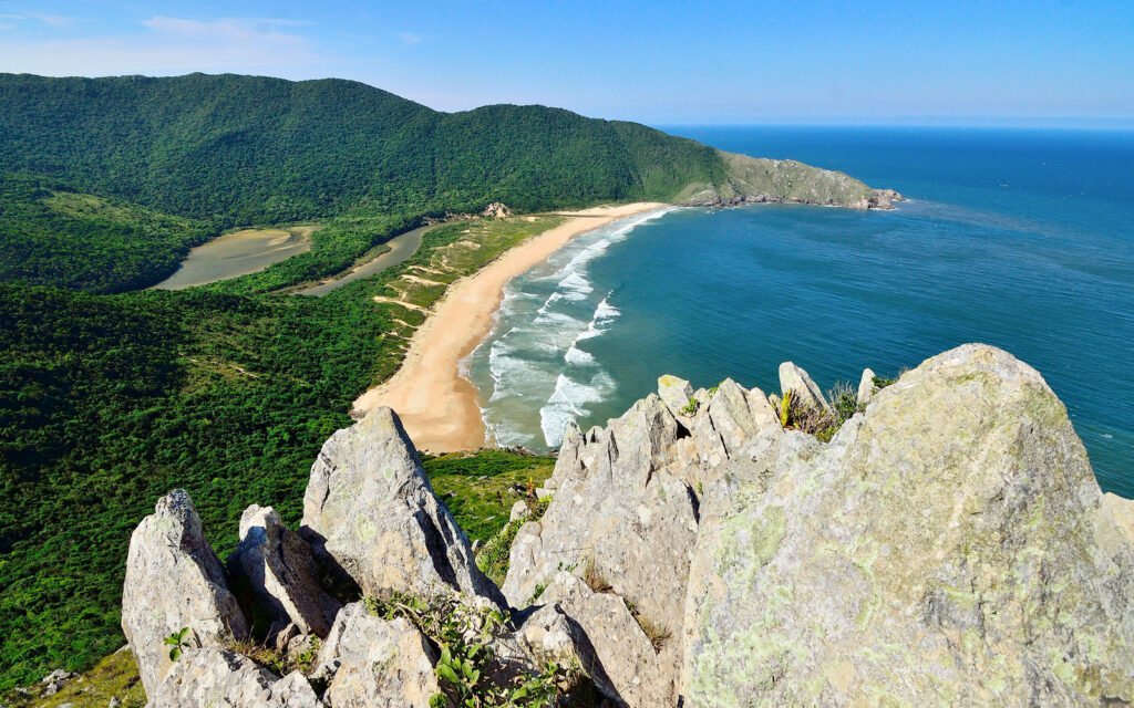
Ultimate Guide to Lagoinha do Leste: How to Reach, What to Pack & Hidden Gems on Florianópolis’ Secret Beach
Picture yourself standing at the edge of paradise – a sweeping crescent of golden sand framed by emerald mountains, waves crashing against untouched shores, and a tranquil lagoon shimmering in the Brazilian sun. This isn’t a beach you stumble upon by accident. Lagoinha do Leste is earned, not given. And that’s exactly what makes it special. Located on Brazil’s stunning Santa Catarina Island in Florianópolis, Lagoinha do Leste has become one of South America’s most talked-about hidden beaches. But here’s the catch – there’s no road leading here. No parking lot. No easy way in. You’ll either trek through Atlantic rainforest or arrive by boat, which keeps the crowds thin and the experience authentic. After two decades exploring off-the-beaten-path destinations across six continents, I can confidently say this 1.2-kilometer stretch of preserved coastline ranks among the most rewarding beach adventures I’ve ever experienced. Quick Reference: Essential Information for Lagoinha do Leste Detail Information Location South Florianópolis, Santa Catarina Island, Brazil Access Methods Hiking trail from Pântano do Sul (2.4 km) or Matadeiro (4.3 km), or boat from Pântano do Sul Hiking Difficulty Moderate to Challenging Hiking Duration 50-60 minutes (Pântano do Sul route); 2-3 hours (Matadeiro route) Boat Cost R$50 one-way, R$80 round-trip (approx. $10-16 USD) Best Time to Visit April-October (autumn/winter for fewer crowds); December-March (summer for warmer water) Beach Length 1.2 km Water Temperature Cold year-round (16-22°C / 61-72°F) Facilities Limited – 2-3 small kiosks (cash only), no bathrooms Conservation Status Protected Natural Park (since 1992) Cell Service Limited/spotty 1. What is Lagoinha do Leste? 🏖️ Lagoinha do Leste translates to “Eastern Lagoon Beach” – and the name tells you everything. This isn’t just another Brazilian beach. It’s a protected conservation area designated as the Parque Natural Municipal da Lagoinha do Leste since 1992, which means construction is permanently banned. No hotels. No restaurants. No roads. Just raw, unfiltered nature. The beach showcases Brazil’s incredible biodiversity. Behind the sand, you’ll find dense Atlantic Forest (Mata Atlântica) – one of the world’s most threatened ecosystems. The forest hums with life: butterflies, lizards, colorful birds, and the occasional monkey swinging through the canopy. The beach itself curves dramatically between two mountain headlands, creating a natural amphitheater where the Atlantic Ocean meets a calm, S-shaped freshwater lagoon. This unique geography creates two completely different swimming experiences. The ocean side delivers powerful waves perfect for surfing, while the lagoon – fed by a small stream cascading down from the mountains – offers warmer, gentler water ideal for a post-hike dip. It’s this contrast that earned Lagoinha do Leste its reputation as Florianópolis’ secret beach, even though locals and savvy travelers have been making the pilgrimage here for decades. 2. How to Get to Lagoinha do Leste – Access Routes & Trail Options 🥾 Here’s where planning matters. You’ve got three main access options, each with distinct advantages: Route Comparison Table Route Starting Point Distance Duration Difficulty Terrain Cost A: Pântano do Sul Trail Rua Manoel Pedro Oliveira 2.4 km 50-60 min Moderate (steep sections) Forest, stairs, rocks Free B: Matadeiro/Armação Trail Praia do Matadeiro 4.3 km 2-3 hours Moderate (longer but gentler) Coastal cliffs, forest Free C: Boat Access Pântano do Sul Beach ~1 km (by sea) 30-40 min Easy Water (can be bumpy) R$50-80 Route A: Pântano do Sul – The Fast Track This is the most popular route for good reason. Starting from Pântano do Sul (a charming fishing village), the trail covers 2.4 kilometers and takes most hikers 50-60 minutes. The path begins on Rua Manoel Pedro Oliveira – just look for the clearly marked trailhead or parking areas charging around R$30 (about $6 USD). The trail immediately plunges into shaded Atlantic Forest. You’ll climb steeply at first – think of it as nature’s StairMaster – before leveling out along a ridge with occasional ocean glimpses. About halfway through, you’ll reach a crucial fork. The main trail continues straight down to the beach, but a right turn takes you to Morro da Coroa viewpoint (more on this gem later). The descent to the beach involves some loose rocks and can get slippery after rain, so solid footwear is non-negotiable. Getting there: From Florianópolis city center, take bus 563 or 564 to Pântano do Sul (about 1.5-2 hours). If driving or using Uber, punch “Trilha Lagoinha do Leste” into GPS. Route B: Matadeiro/Armação – The Scenic Marathon This 4.3-kilometer trail starts near Praia da Armação and winds along dramatic coastal cliffs before cutting inland through forest. It takes 2-3 hours but rewards you with spectacular panoramic views, including Toca da Baleia (Whale Cave), Florianópolis’ largest aquatic cave. The trail hugs cliffsides for much of the route – not for anyone with a fear of heights – but the scenery is absolutely worth it. You’ll spot multiple beaches, distant islands, and if you’re lucky (July-October), migrating whales offshore. The path eventually merges with the Pântano do Sul trail near the beach. Best for: Experienced hikers who want a longer adventure and don’t mind the extended commitment. Route C: Boat from Pântano do Sul – The Shortcut Not feeling the hike? Boats depart regularly from Pântano do Sul Beach (north end) between 9 AM and 5 PM, charging R$50 one-way or R$80 round-trip. The 30-40 minute ride offers stunning coastal perspectives and a totally different experience of the landscape. Important notes: Many smart travelers hike one way and boat back – getting the trail experience without the exhaustion of a round-trip trek. 3. Trail & Hike Tips for Lagoinha do Leste 💪 Let’s talk reality. This isn’t a casual beach stroll. The Pântano do Sul trail involves steep climbs, uneven terrain, and sections where you’re basically scrambling over roots and rocks. It’s rated moderate to challenging for a reason. Terrain Breakdown First 20 minutes: Steep uphill through dense forest. You’ll gain about 100 meters of elevation quickly. The canopy provides shade, which is a blessing, but humidity can make breathing feel harder. Middle section: Rolling terrain along ridgelines with occasional clearings.
