Indians Traveling Phu Quoc Advisory 2026: Visa Rules, Hidden Risks & Must-Know Travel Guidelines
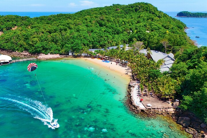
Every week at Astamb Holidays, I get at least a dozen calls from excited travelers asking about Phu Quoc. And honestly, I get it. The island is gorgeous — white sand beaches, crystal-clear water, fresh seafood, and a surprisingly chill vibe. But here’s what worries me as someone who handles travel operations daily: a lot of Indians are flying to Phu Quoc without fully understanding the rules. The Indians traveling Phu Quoc advisory issued by the Embassy of India in Hanoi on April 6, 2026, changes things significantly. Before you book those flights, please read this. It could save your trip — or your passport. 🛂 What Is the Latest Indians Traveling Phu Quoc Advisory in 2026? As of April 6, 2026, the Embassy of India in Hanoi issued a formal advisory warning Indian nationals about the risks of traveling to Phu Quoc Island on a visa-free basis. While Phu Quoc does allow 30-day visa-free entry for Indians under its Special Economic Zone rules, the exemption is strictly limited to the island. Any movement to mainland Vietnam — even in an emergency — without a valid Vietnam e-visa can lead to serious immigration complications, travel restrictions, and legal delays. My take: This is not a scare tactic. This is the Indian government telling you to be careful. Read the full advisory on the official Embassy of India in Vietnam page before you travel. ✅ Can Indians Travel to Phu Quoc Without a Visa in 2026? Yes — but with strict conditions. Indians can visit Phu Quoc Island visa-free for up to 30 days because Phu Quoc is classified as a Special Economic Zone (SEZ) under Vietnam law, a status it has held since 2005. This means the island has its own entry rules separate from the rest of Vietnam. However — and this is crucial — this visa exemption does not give you access to mainland Vietnam. It covers Phu Quoc only. The moment you step onto mainland Vietnamese soil (even at Ho Chi Minh City’s Tan Son Nhat International Airport for immigration), you need a valid visa. 📋 What Are the Visa-Free Rules Indians Must Follow in Phu Quoc? Here are the exact conditions you must meet to use the Phu Quoc visa-free entry: One thing I tell every client: print your return ticket. Immigration officers at Phu Quoc International Airport will ask for it. Having it only on your phone is a risk — what if your battery is dead? ⚠️ What Happens If Indians Break Phu Quoc Visa Rules? This is the section most travel agents skip. Let me walk you through three real-world scenarios I’ve seen or been told about: Scenario 1: Your Flight Routes Via Ho Chi Minh City You book a “cheap” flight from Mumbai → HCMC → Phu Quoc. You land at Tan Son Nhat International Airport and need to clear immigration to catch your domestic connection. You have no Vietnam e-visa. You get stopped, questioned, and potentially denied boarding to Phu Quoc — or sent back to India. Scenario 2: A Medical Emergency Forces You to the Mainland You’re on Phu Quoc, you fall sick, and the local hospital can’t handle it. The nearest major hospital is in Ho Chi Minh City. But you entered on a visa-free stamp — no mainland access. Without a valid Vietnam visa, getting that emergency transfer approved involves immigration complications that can cost you precious hours. The Embassy of India advisory specifically highlights this risk. Scenario 3: Your Return Flight Gets Cancelled Airlines cancel flights. It happens. If your only return option reroutes through Hanoi or HCMC for a domestic-to-international transfer, you may be stuck. Without a mainland Vietnam visa, you cannot legally transit through immigration. You’re in a legal grey zone, and the Vietnam Immigration office won’t be sympathetic just because your airline messed up. The Embassy of India has directly stated: “If you are required to travel to mainland Vietnam for reasons as mentioned above, please understand that there could be immigration-related complications.” 🛡️ Is It Safe for Indians to Travel to Phu Quoc Right Now? Yes, Phu Quoc is generally safe — but safety has layers: Physically: Phu Quoc is one of Vietnam’s safest tourist destinations. Petty crime is low compared to major Southeast Asian cities. The local population is friendly toward Indian tourists. Weather: The dry season runs from November to April, making it peak time to visit. May to October is the monsoon season — seas get rough, and some water activities shut down. Legally: This is where caution is needed. As a visa-free traveler, you have zero buffer if plans change. One flight cancellation, one health issue, one wrong turn can put you in a complicated spot with Vietnam Immigration authorities. My recommendation: Travel with a valid Vietnam e-visa even if you’re only planning to stay on Phu Quoc. It gives you a safety net that the visa-free route simply doesn’t. 💡 Should Indians Apply for a Vietnam Visa Instead? Wahid Ali’s honest recommendation: Yes, get the e-visa. Here’s the comparison that makes it clear: Factor Phu Quoc Visa-Free Vietnam E-Visa ($25 USD) Cost Free ~₹2,100 (~$25 USD) Processing Time Instant on arrival 3–5 working days Coverage Phu Quoc Island only All of Vietnam Emergency Protection None Full mainland access Flight Flexibility Direct to PQC only Any Vietnam airport Peace of Mind Low High Valid Duration 30 days Up to 90 days For ₹2,100, you get 90-day multi-entry access to all of Vietnam, the freedom to explore Ho Chi Minh City, Hanoi, or Da Nang before or after Phu Quoc, and — most importantly — you’re covered if anything goes wrong. In my 20 years of running travel operations, I’ve never once regretted advising a client to spend a little extra on a visa. I have, however, received panicked calls from people who didn’t. Apply through the official Vietnam Immigration Portal: https://evisa.xuatnhapcanh.gov.vn ✈️ Best Travel Routes Indians Must Follow Safe Route 1: Direct International Flights to Phu Quoc (PQC)