Skip to content
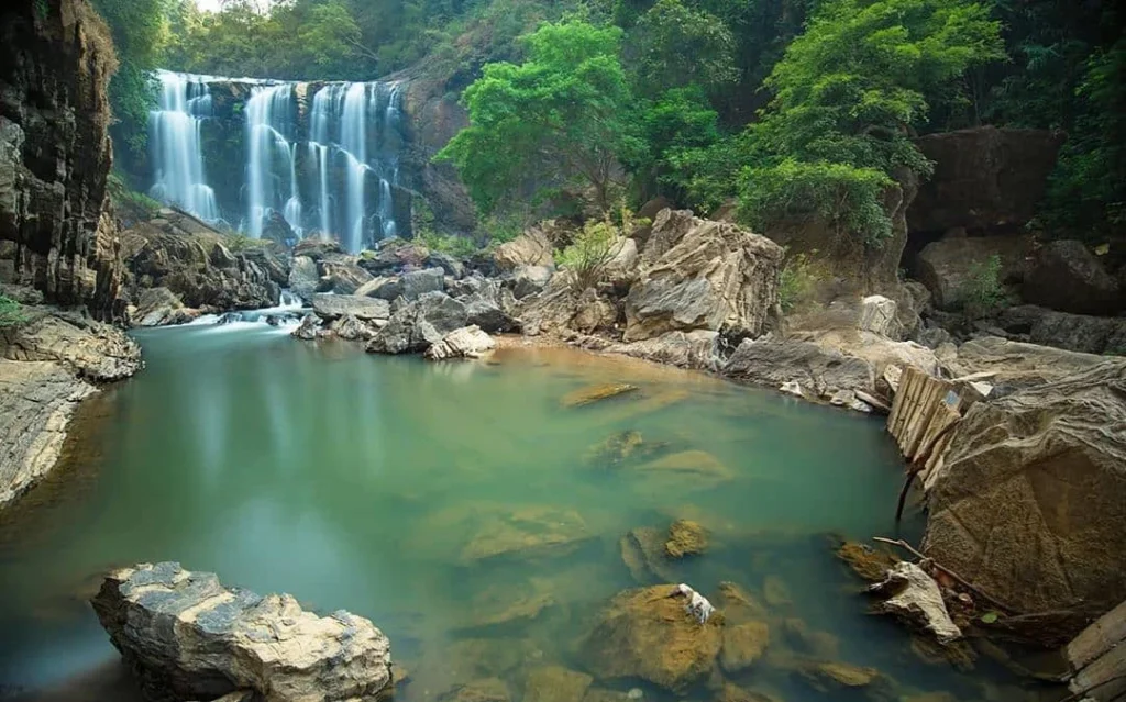
Sathodi Falls Travel Guide 2026: How to Reach, Best Time, Trekking & FAQs
I still remember the first time I stood in front of Sathodi Falls—the thundering cascade of water, the emerald green pool at its base, and the sheer raw power of nature in the Western Ghats. It was during a monsoon recce trip I was organizing for Astamb Holidays, and I knew instantly that this was one of those rare finds that don’t make it to every travel brochure. Often called the “Mini Niagara of Karnataka,” Sathodi Falls is tucked away in the dense forests of Uttara Kannada District, and frankly, it’s the kind of place that makes you feel like you’ve discovered something truly special. I’m Wahid Ali, and I’ve been in the travel business for 20 years now, managing operations and crafting experiences that go beyond the usual tourist circuits. Based in Mumbai, I head operations at Astamb Holidays, where we focus on destinations that offer genuine cultural richness and natural beauty. Sathodi Falls checks every box—adventure, photography, nature, and that authentic “off-the-map” feeling that seasoned travelers crave. 2026 is shaping up to be the year for exploring the Western Ghats properly. With improved road connectivity, better awareness about sustainable tourism, and travelers actively seeking hidden gems over crowded hotspots, places like Sathodi Falls are finally getting the attention they deserve. Whether you’re a family looking for a weekend escape, a solo traveler chasing waterfalls, or a trekking enthusiast wanting something different from the usual trails, this guide will give you everything you need to plan your visit like a pro. 🗺️ Where is Sathodi Falls Located? Sathodi Falls sits in the heart of the Uttara Kannada District in Karnataka, about 32 kilometers from the town of Yellapur. The waterfall is part of the Kallaramane Ghat region, which is known for its thick forest cover, winding roads, and dramatic landscapes shaped by the Kali River system. Here’s what makes the location interesting from a geographical standpoint: the Kodasalli Dam on the Kali River has significantly altered the water flow patterns in this region. During the monsoon months (June to September), when the dam releases excess water, Sathodi Falls transforms into a roaring spectacle. The waterfall drops from a height of approximately 15 meters over a wide rocky ledge, creating that signature curtain-like effect that earned it the “Mini Niagara” nickname. The falls are located at the coordinates 14.9167° N, 74.6833° E (you can plug this directly into Google Maps). The surrounding area is part of the Western Ghats biodiversity hotspot, so you’re looking at pristine forests, diverse wildlife, and some seriously fresh air. The Kallaramane Ghat road itself is a scenic drive, though I’ll be honest—it’s not for the faint-hearted during heavy rains. Quick Location Reference: 🚗 How to Reach Sathodi Falls (The Logistics) Getting to Sathodi Falls requires some planning, but that’s part of the adventure. In my 20 years of managing tours, I’ve learned that the journey to hidden waterfalls is often as memorable as the destination itself. Here’s the breakdown based on where you’re starting from: From Goa (Nearest Major Hub) From Hubli From Bangalore Nearest Transport Hubs: Transport Mode Location Distance from Sathodi Falls Airport Hubli Airport 95 km Airport Dabolim Airport (Goa) 110 km Railway Station Londa Junction 65 km Railway Station Hubli Junction 95 km Bus Stand Yellapur Bus Stand 32 km Expert Tips from the Field: Vehicle Recommendation: Based on my experience organizing trips here, I strongly recommend a high-clearance vehicle like an SUV or a sturdy hatchback with good ground clearance. The last 8-10 kilometers before the falls involve navigating through forest roads with potholes, loose gravel, and during monsoons, occasional water crossings. Sedans can make it, but you’ll be holding your breath at several points. Parking Situation: There’s a small clearing about 500 meters from the actual waterfall where you can park your vehicle. It’s not a formal parking lot—just an open area where locals have designated space. Arrive early (before 9 AM) during weekends to secure a spot, especially between October and January when visitor numbers peak. Road Conditions Warning: The stretch from Yellapur to Sathodi Falls is maintained by the forest department, and road quality can vary dramatically depending on recent rainfall. I always tell my clients to check with locals in Yellapur about current road conditions before heading out. A quick stop at a tea shop or asking the auto-rickshaw drivers gives you real-time intel. Fuel & Facilities: Fill up your tank in Yellapur. There are no fuel stations once you head toward the falls. Also, carry sufficient water, snacks, and a basic first-aid kit. Mobile network coverage (primarily BSNL and Jio) becomes spotty after Yellapur. 📅 Best Time to Visit Sathodi Falls Timing your visit to Sathodi Falls can make the difference between an okay experience and an absolutely spectacular one. Having visited during different seasons for site inspections, I can break this down month by month so you know exactly what to expect. Monthly Breakdown: Month Water Flow Crowd Level Trekking Conditions Recommendation January Moderate Low Excellent ⭐⭐⭐⭐ Great February Low-Moderate Low Excellent ⭐⭐⭐ Good March-May Low Very Low Hot & Dry ⭐⭐ Average June-August Very High Moderate Risky ⚠️ Avoid September High Low-Moderate Slippery ⭐⭐⭐ Good October High Moderate Good ⭐⭐⭐⭐⭐ Excellent November Moderate-High High Excellent ⭐⭐⭐⭐⭐ Excellent December Moderate Moderate Excellent ⭐⭐⭐⭐ Great The Sweet Spot: October to January This is when Sathodi Falls is at its absolute best. The monsoon has just ended, so the waterfall still has impressive volume, but the trails have dried out enough to be safe. The weather is pleasant—temperatures range between 15°C and 25°C—and the surrounding forest is lush and green from the recent rains. October and November are my personal favorites. I’ve organized numerous group trips during this window, and the feedback is consistently excellent. The water flow is strong enough to create that dramatic curtain effect, the pool at the base is perfect for a quick dip, and the lighting is ideal for photography. Monsoon Months: June to August (Proceed with Caution) Yes, the
Sathodi Falls Travel Guide 2026: How to Reach, Best Time, Trekking & FAQs Read More »