Skip to content
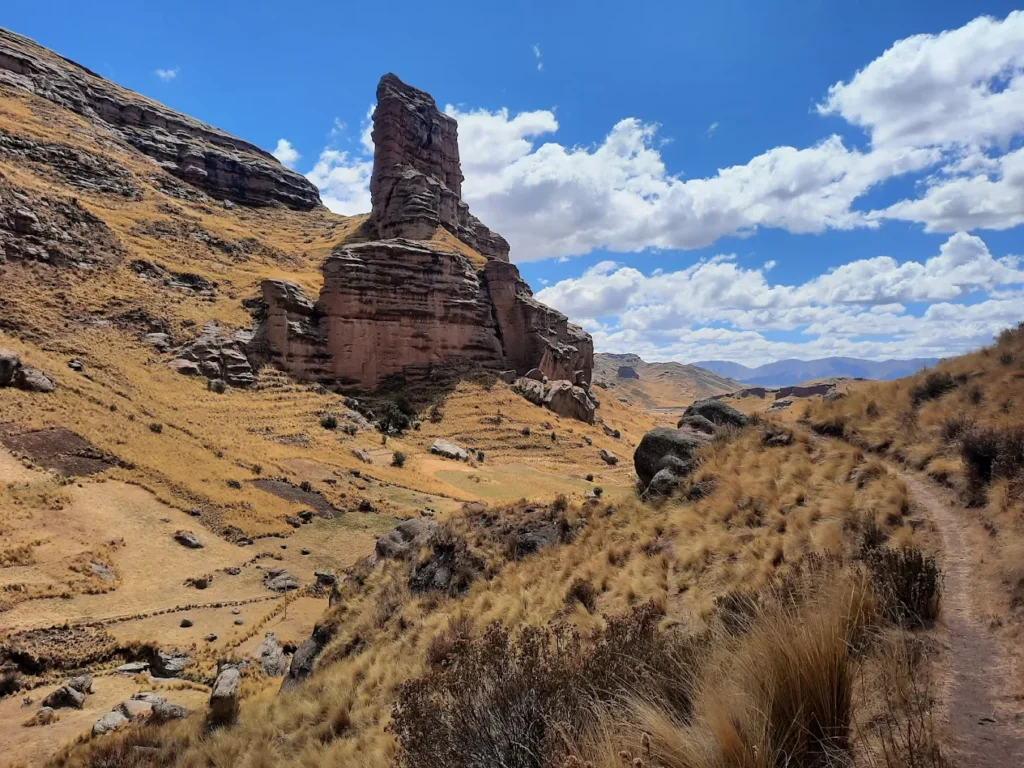
Tinajani Canyon Peru: Ultimate Travel Guide to the Valley of Stone Giants, Elevation, Trails & FAQs
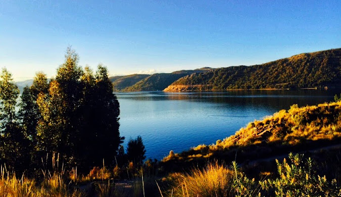
When I first heard about Tinajani Canyon Peru from local guides during my years organizing tours across the Andes, I knew this was one of those rare destinations that could genuinely surprise even seasoned travelers. Imagine towering red rock formations reaching 50 meters into the sky, sculpted over millions of years into shapes that look like frozen giants—some say they resemble castles, others see sphinxes, and a few swear they spot turtles or monks in stone. This is the Valley of Stone Giants, a geological wonder hiding in plain sight just 150 kilometers north of Puno, yet known to only a fraction of Peru’s visitors. In my experience managing tours through Peru’s highlands, Tinajani Canyon stands out as the perfect detour for travelers seeking authentic Andean experiences without the crowds that flock to Lake Titicaca or Machu Picchu. The canyon sits at a serious elevation—between 3,895 to 4,059 meters above sea level—so proper acclimatization isn’t optional, it’s essential. But for those who take the time to prepare, this remote corner of the Puno region rewards visitors with otherworldly landscapes, rich Quechua and Aymara cultural significance, and the kind of silence you can only find in Peru’s most untouched places. 🏔️ What Is Tinajani Canyon Peru? Tinajani Canyon Peru is a geological formation in the Melgar province of the Puno region, characterized by massive red sandstone towers and ravines carved by wind and water erosion over millions of years. The canyon covers approximately 200-250 hectares and sits at an elevation ranging from 3,895 to 4,059 meters (12,779 to 13,317 feet) above sea level. The name “Tinajani” comes from the Quechua word “tinaja” (meaning pot or jar), referring to the peculiar jar-like shapes of some rock formations. Locals also call it the “Devil’s Canyon” (Cañón del Diablo) due to ancient legends about supernatural forces dwelling among the rocks. Located just 12-14 kilometers southeast of Ayaviri in the Melgar province, the canyon is divided into three main ravines: Queñuacuyo, Pacobamba, and Huarachani. The Pacobamba River flows through the canyon with crystal-clear waters, creating a sharp contrast against the rust-colored sandstone walls. | Quick Reference: Tinajani Canyon Basics | |—|—| | Location | Melgar Province, Puno Region, Peru | | Distance from Puno | 150 km north | | Distance from Ayaviri | 12-14 km southeast | | Elevation | 3,895-4,059 m (12,779-13,317 ft) | | Area Coverage | 200-250 hectares | | Main River | Pacobamba River | | Rock Type | Red sandstone | | Alternative Names | Valley of Stone Giants, Devil’s Canyon | 🌍 Geological & Natural Overview 🗿 How Was Tinajani Canyon Formed? From conversations with local geologists during tour planning sessions, I’ve learned that Tinajani Canyon’s origin story reads like a geological thriller. Millions of years ago, this entire region sat beneath an ancient lake called Lake Ballivián—a predecessor to Lake Titicaca and Lake Poopó. Red sandstone sediments accumulated on this lake bed over countless millennia, layer upon patient layer. Then came the dramatic plot twist: volcanic activity and tectonic movements lifted these sedimentary deposits high into the Andes. As the climate shifted and the ancient lake dried up, the exposed sandstone faced a new sculptor—wind. Combined with freeze-thaw cycles, seasonal rains, and the relentless Andean winds, erosion carved the soft sandstone into the formations we see today. This process continues even now. Every rainy season, every windstorm subtly reshapes the canyon’s profile, meaning the Tinajani you visit today will be slightly different from the one visitors see a decade from now. 🏛️ Rock Formations & “Valley of Stone Giants” The star attractions are undoubtedly the towering rock spires, some reaching heights of 50 meters or more. Walking among these giants, you feel small—in the best way possible. I’ve watched countless travelers stop mid-stride, cameras forgotten, just staring up at formations with names like El Vigía (The Watchman), The Friar, The Castle, and The Turtle. The characteristic reddish-orange hue comes from iron oxide in the sandstone, and the color intensity changes throughout the day. At sunrise, the rocks glow soft pink. By midday, they turn burnt orange. At sunset—and this is when I always tell clients to have their cameras ready—the formations blaze copper and gold against purple shadows. The shapes are left to your imagination. Some rocks look eerily human, others like massive animals frozen mid-movement. Anthropomorphic formations (human-shaped rocks) are common, which has fueled local legends about petrified giants. 🌿 Flora & Fauna Highlights Despite the harsh, high-altitude environment, Tinajani Canyon supports surprising biodiversity. The star of the botanical show is the Puya Raimondii—also called the Queen of the Andes. This is the world’s largest bromeliad, and seeing one is like encountering a plant from another planet. Puya Raimondii can reach heights of 10-15 meters when in bloom, producing thousands of flowers on a single spike. These ancient plants live for 60-100 years, bloom once in their lifetime, then die—a dramatic, once-in-a-century flowering event. They grow at altitudes between 3,200-4,800 meters, making Tinajani’s elevation perfect habitat. Other vegetation includes hardy ichu grass, queñua trees (sacred in Andean culture), and various highland shrubs adapted to extreme temperature swings. Wildlife sightings include Andean foxes, vicuñas (wild relatives of llamas), various hummingbird species (including the black metaltail hummingbird that lives among the puyas), Andean geese, and if you’re very lucky, the majestic Andean condor soaring on thermal updrafts. ⛰️ Elevation & Altitude Facts 📏 How High Is Tinajani? Tinajani Canyon sits at elevations between 3,895 and 4,059 meters above sea level (12,779 to 13,317 feet). To put this in perspective: The main entrance and museum area typically sit around 3,913 meters, while hiking trails can take you above 4,000 meters. 🩺 Altitude Sickness (Soroche) – What You Need to Know Here’s where my operations experience becomes critical. Altitude sickness (soroche in local Spanish) is a real concern at these heights, and I’ve seen too many travelers underestimate it. Common symptoms include: My recommended acclimatization strategy: Pro tip from years of tour planning: If you experience severe symptoms (confusion,