Travel Blog

Things to Do in Diveagar – The Complete Guide for Your Weekend Escape

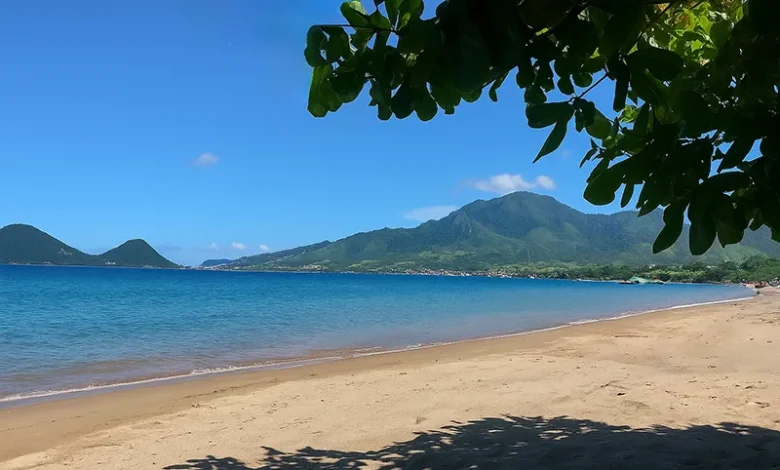
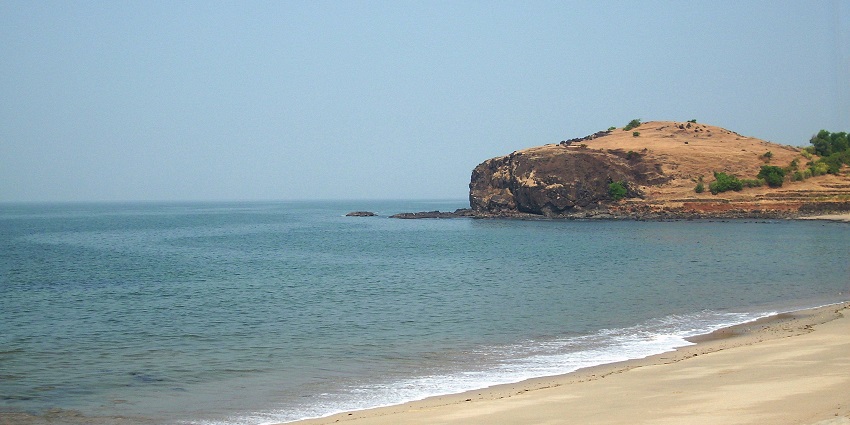
Picture this: soft waves gently kissing a stretch of pristine sand, coconut groves swaying in the salty breeze, and fishing boats dotting the horizon as the sun paints the sky in shades of orange and pink. Welcome to Diveagar, a hidden gem tucked along Maharashtra’s stunning Konkan coastline. Unlike the crowded beaches you’re probably tired of, this peaceful paradise offers the perfect blend of relaxation and adventure. Whether you’re hunting for the best things to do in Diveagar or simply craving a break from city chaos, this coastal village delivers an authentic experience that’ll refresh your soul. Just a comfortable drive from Mumbai or Pune, Diveagar has become my go-to spot whenever I need to hit the reset button. What makes it special? It’s the rare combination of untouched natural beauty, rich cultural heritage, thrilling water sports, and some of the most mouthwatering seafood you’ll ever taste. This guide covers everything you need to plan the perfect weekend escape—from the safest routes to hidden spots only locals know about, plus practical tips on where to stay, what to eat, and how to make every moment count. Quick Information: Diveagar at a Glance Category Details Distance from Mumbai Approx. 170 km (4-5 hours by road) Distance from Pune Approx. 180 km (4-5 hours by road) Best Time to Visit October to March (pleasant weather); June-Sept (monsoon beauty) Ideal Duration 1-2 nights (2 days recommended) Main Attractions Diveagar Beach, Suvarna Ganesh Temple, Water Sports, Phansad Wildlife Sanctuary Average Budget (2 Days) ₹3,000-₹8,000 per person (depending on accommodation) Food Specialty Fresh seafood, fish curry-rice, solkadhi, bombil fry Nearby Attractions Shrivardhan Beach (8 km), Harihareshwar (25 km), Murud-Janjira Fort (50 km) 1. Reach & Best Time: Planning Your Things to Do in Diveagar How to Reach Diveagar from Mumbai and Pune Getting to Diveagar is half the adventure! The journey takes you through scenic countryside, traditional villages, and lush greenery that’ll have you reaching for your camera. From Pune (Recommended Route): Here’s the route I always take—it’s smoother and safer. From Pune, take the Expressway to Khalapur and go via Pali and Mangaon to Diveagar. This route keeps you on better-maintained roads and cuts down on those nerve-wracking narrow patches. The entire journey takes about 4-5 hours, depending on traffic and how many chai stops you make (and trust me, you’ll want to stop at least once!). From Mumbai: Head out via the Mumbai-Goa Highway (NH66), take the turn at Mangaon, and follow the signs to Diveagar. The route passes through Mahad and offers gorgeous views of the Western Ghats. Early morning starts work best to avoid city traffic—aim to leave by 6 AM and you’ll reach in time for a late breakfast by the beach. By Train + Taxi: The nearest railway station is Mangaon (about 40 km away). From there, you can hire a taxi or catch a local bus. Check train schedules on Indian Railways for the most current timings. Pro Tip: Keep your fuel tank topped up—petrol pumps become sparse once you’re deep into the Konkan region. Best Time to Visit Diveagar October to March is absolutely perfect for beach lovers. The weather stays pleasant (20-30°C), the sea is calm enough for water sports, and you can spend hours on the sand without getting scorched. I remember watching the most stunning sunset in January—the sky turned into this incredible canvas of purples and golds. Monsoon (June-September) transforms Diveagar into a lush green paradise. The countryside becomes absolutely breathtaking, but here’s the catch—the sea gets rough and most water activities shut down. If you’re someone who loves rain-soaked landscapes and doesn’t mind skipping the beach swim, monsoon has its own magical charm. Summer (April-May) can get pretty hot and humid, though it’s still manageable if you stick to early mornings and evenings. How Long Should You Stay? Two days are enough to cover all the major attractions leisurely if you start early in the morning. A single night works if you’re really pressed for time, but you’ll be rushing. My best advice is to take it slow—this place deserves more than a quick checklist visit. Unique Tip: Set your alarm for an early morning walk on Diveagar Beach before 7 AM. The beach is practically empty, the air is crisp, and you might spot fishermen hauling in their fresh catch. It’s a completely different vibe from the afternoon crowd scene. 2. Diveagar Beach: Sun, Sand & Sea-side Strolls The star attraction! Diveagar Beach stretches for about 3 kilometers and offers a unique blackish-white sand mix (thanks to the minerals from the Sahyadri ranges). Unlike some Konkan beaches with steep drops, Diveagar has a gentle slope that makes it incredibly safe for families with kids. The waves here are relatively calm compared to other beaches along the coast. Sunrise & Sunset Magic The beach faces west, making it a sunset lover’s dream. But here’s a secret most tourists miss—head to the northern end near the coconut grove around 6:30 AM. You’ll find a quieter spot where local fishermen prepare their boats, and the morning light creates this golden glow across the sand. It’s perfect for photography or just soaking in the peaceful vibes. Sunset happens around 6-6:30 PM (depending on the season), and the entire beach comes alive. Families spread out picnic mats, couples take long walks, and food vendors start setting up their stalls. The sight of the sun dipping into the Arabian Sea never gets old. What Makes This Beach Special The fishing village vibe is authentic—no over-commercialization or pushy vendors. You’ll see traditional fishing boats (called nausenas) lined up on the shore, and if you’re lucky, you might witness the fishermen coming back with their morning catch. The coconut groves provide natural shade, perfect for when the afternoon sun gets intense. What to Pack Insider Tip: Walk towards the fishing village on the southern end of the beach. You’ll find a small path leading through coconut groves that opens up to a quieter beach section. This is where

Things to Do in Diveagar – The Complete Guide for Your Weekend Escape Read More »

Why is Amboli Ghat Famous? A Deep Dive into Maharashtra’s Hidden Hill-Station

Picture this: You’re driving through thick mist, waterfalls cascading right next to your car, and suddenly the clouds part to reveal a breathtaking valley stretching endlessly below. Welcome to Amboli Ghat, Maharashtra’s best-kept secret that’s been quietly stealing hearts for decades. Why is Amboli Ghat famous? Simply put, it’s the ‘Cherrapunji of Maharashtra’ – a place where nature puts on its most spectacular show during the monsoons, where biodiversity thrives like nowhere else in the state, and where misty mountain magic meets the dramatic drop to the Konkan coast. This Amboli hidden gem Maharashtra offers isn’t just another hill station; it’s an experience that lingers long after you’ve left. Tucked away in the Western Ghats Maharashtra, Amboli transforms into a wonderland between June and September. The moment you arrive, you’ll understand why travelers, nature photographers, and adventure seekers can’t stop talking about this place. Whether you’re chasing waterfalls, spotting rare frogs, or simply soaking in the cool mountain air while munching on piping hot bhajis, Amboli delivers experiences that big-name tourist spots simply can’t match. Quick Information Table: Amboli Ghat at a Glance Feature Details Location Sindhudurg District, Maharashtra Altitude Approximately 690 meters (2,264 feet) Famous For Heavy monsoon rainfall, waterfalls, biodiversity hotspot Nickname “Cherrapunji of Maharashtra” Annual Rainfall Over 7,500 mm Source: India Meteorological Department Best Season June to September (Monsoon) Nearest Airport Goa International Airport (95 km), Belgaum Airport (90 km) Nearest Railway Station Sawantwadi Road (32 km) Distance from Mumbai Approximately 525 km (10-11 hours drive) Key Attractions Amboli Waterfall, Kavlesad Point, Nangarta Falls, Hiranyakeshi Temple Wildlife Significance Western Ghats UNESCO World Heritage Site, biodiversity hotspot 1. Location & Landscape – Why Amboli Ghat Stands Out Amboli Ghat sits perched at roughly 690 meters above sea level in Maharashtra’s Sindhudurg district, marking the final Amboli hill station before the land dramatically plunges toward the Konkan coast. This isn’t your typical plateau hill station – Amboli is positioned right on the edge, where the mighty Sahyadri range rain forest meets the Arabian Sea’s coastal plains. What makes this location truly special? It’s all about the geography. The Western Ghats Maharashtra section here acts like a giant natural wall, forcing moisture-laden monsoon winds from the Arabian Sea to rise rapidly. As these winds climb the steep slopes, they cool down and release their moisture – creating the perfect recipe for those legendary rains and the lush green carpet that covers every inch of the landscape Source: Western Ghats Ecology Studies, biodiversityindia.org. Stand at any viewpoint in Amboli, and you’ll witness nature’s drama unfold. On one side, dense tropical forests climb the mountain slopes, their canopy so thick that sunlight barely touches the forest floor. On the other, the land drops away sharply into the Konkan belt, revealing distant villages, rice paddies, and on clear days, even glimpses of the Arabian Sea shimmering in the distance. The “ghat” section – meaning mountain pass – winds through this terrain with hairpin bends that challenge even experienced drivers. But these twisting roads are part of Amboli’s charm. Each turn reveals something new: a hidden waterfall, a viewpoint shrouded in mist, or suddenly, an explosion of color from wildflowers clinging to rocky outcrops. The landscape here doesn’t just look pretty; it tells the story of millions of years of geological evolution, where ancient volcanic activity, erosion, and the relentless monsoons have sculpted a masterpiece. 2. Heavy Rainfall & Monsoon Magic – A Major Reason Why Amboli Ghat is Famous Let’s talk about rain – and not just any rain. Amboli Ghat records an average annual rainfall of over 7,500 mm, earning its well-deserved nickname as the “Cherrapunji of Maharashtra” Source: Indian Institute of Tropical Meteorology. Between June and September, the skies open up with such intensity that the entire region transforms into a living, breathing water world. Imagine waking up to the sound of rain drumming on your roof, stepping outside to see waterfalls that weren’t there yesterday now thundering down every cliff face, and watching mist roll through valleys like waves in slow motion. This is Monsoon waterfall Amboli season – when the hill station becomes absolutely magical. The already green landscape turns several shades deeper, streams swell into roaring rivers, and the air fills with the fresh, earthy smell of petrichor mixed with wild flowers. But here’s the thing about Amboli’s monsoons: they’re not gentle. The rain comes down with purpose, creating conditions that are both spectacular and demanding respect. Roads can become slippery, visibility drops to just a few meters, and those charming streams can turn into powerful torrents within hours. Your 3-Point Monsoon Safety Guide for Amboli: The monsoon here isn’t just weather; it’s an event. Local residents celebrate the first rains with festivals, and you’ll find families gathering around steaming cups of chai, sharing stories while the world outside turns silver with rain. This is when Amboli shows its true colors – quite literally, as the waterfalls create rainbow mists in the afternoon sun between showers. 3. Waterfalls & Viewpoints – The Visual Wonders That Make Amboli Ghat Famous Let’s get to the main attractions that keep cameras clicking and jaws dropping throughout the monsoon season. The Amboli water fall Maharashtra scene isn’t just about one or two cascades – it’s about dozens of waterfalls appearing across the landscape like nature’s own art installation. Amboli Waterfall stands as the star performer. Located just 6 kilometers from the main town, this multi-tiered cascade drops approximately 30 meters in a series of steps, creating natural pools where locals and visitors (carefully!) enjoy the cool mountain water. During peak monsoon, the falls swell dramatically, and the spray creates a constant mist that rainbows dance through when sunlight breaks through the clouds. The surrounding area has been developed with viewing platforms and steps, making it accessible while maintaining its natural beauty. Pro tip: Visit early morning around 7 AM to catch the falls in golden morning light and avoid the crowds. Nangarta Falls, about 4 kilometers away, offers a completely different

Why is Amboli Ghat Famous? A Deep Dive into Maharashtra’s Hidden Hill-Station Read More »

What to Do in Salento, Colombia: 10 Unforgettable Experiences Beyond the Wax Palms

Picture this: you’re standing on a cobblestone street lined with candy-colored colonial houses, each one painted in shades of sunshine yellow, electric blue, and fiery orange. The air smells like freshly brewed coffee mixed with the earthy scent of rain on mountain soil. Behind you, the Andes Mountains rise up like sleeping giants, and somewhere in the distance, the world’s tallest palm trees are swaying in the breeze like nature’s own skyscrapers. Welcome to Salento, Colombia—a tiny mountain town that punches way above its weight when it comes to charm, adventure, and pure travel magic. Whether you’re a solo traveler looking for your next adventure, a family planning a holiday that combines nature and culture, or just someone who wants to escape the noise of everyday life, Salento has something special waiting for you. This isn’t your typical tourist trap. Sure, everyone knows about the famous wax palms in Valle de Cocora, but what to do in Salento Colombia goes far beyond that single (admittedly spectacular) experience. In this guide, I’ll walk you through 10 unforgettable experiences that showcase the real heart of this Salento Colombia coffee region gem. From hiking cloud forests to sipping coffee straight from the farm, exploring hidden waterfalls, and even learning a quirky local game involving gunpowder (yes, really!), you’re about to discover why Salento should be at the top of your Colombia bucket list. Quick Information Table Category Details Best Time to Visit December to March (dry season) or June to August Recommended Stay 3-4 days for full experience; 2 days minimum Main Activities Hiking, coffee tours, viewpoints, day trips Getting There Fly to Pereira or Armenia, then 1-hour bus ride Budget Range $30-60 USD per day (mid-range traveler) Ideal For Solo travelers, families, nature lovers, coffee enthusiasts Language Spanish (basic English in tourist areas) Safety Level Very safe for tourists, including solo travelers Planning Your Salento Adventure: Getting There & Orienting Yourself How to Reach Salento Getting to Salento is easier than you might think, though it does require a bit of planning. The town sits in Colombia’s Coffee Triangle (Eje Cafetero), nestled between the larger cities of Armenia and Pereira. By Air: Your best bet is flying into either Matecaña International Airport in Pereira (45 minutes away) or El Edén International Airport in Armenia (30 minutes away). [Cite Source: Colombian Civil Aviation Authority]. From there, you’ll hop on a local bus or arrange a private transfer. Buses run regularly throughout the day and cost around 8,000-10,000 Colombian pesos (roughly $2-3 USD). By Bus: If you’re coming from Bogotá, expect a scenic 8-10 hour bus journey through the mountains. From Medellín, it’s about 6-7 hours. Companies like Expreso Bolivariano and Expreso Palmira offer comfortable overnight buses with reclining seats. [Cite Source: Terminal de Transporte websites] Pro Tip for Solo Travelers: The bus terminals in Pereira and Armenia are safe, but arrive during daylight hours if possible. Keep your valuables close and use official taxi services or apps like DiDi or InDriver for the final leg to Salento. Orienting Yourself in Town Salento is wonderfully compact—you can walk from one end to the other in about 15 minutes. The heart of town is the Plaza de Bolívar, surrounded by restaurants, artisan shops, and cafés. From the plaza, Calle Real (also called Carrera 6) is the Instagram-famous street lined with colorful colonial architecture that climbs uphill toward the Mirador Alto de la Cruz. The Mirador Salento Colombia view is worth the 240-step climb. You’ll get panoramic views of the valley below, with the wax palms of Cocora visible on clear days. Go at sunset for the most dramatic lighting—the golden hour turns those colorful buildings into something out of a storybook. Best Time to Visit Salento Colombia Timing matters in the mountains. Salento has two dry seasons: December through March and June through August. These months offer the clearest skies for hiking the Cocora Valley wax palms trail and exploring surrounding nature. That said, this is the cloud forest—rain is part of the charm. Even during “dry” season, afternoon showers are common. The rainy seasons (April-May and September-November) bring lush green landscapes and fewer crowds, though trails can get muddy. Weekend vs. Weekday: Salento gets packed with Colombian tourists on weekends and holidays. If you’re looking for a quieter experience, visit mid-week. You’ll have trails more to yourself and won’t wait in line for jeeps to Cocora Valley. Where to Stay Accommodation options range from $10 USD hostel dorms to $80+ boutique hotels. For solo travel Salento Colombia adventures, try hostels like The Plantation House or La Serrana Eco Farm Hostel—both are social spots perfect for meeting other travelers. Families might prefer places like Hotel Salento Real or Casa de las Palmas, which offer private rooms with mountain views. The Magnificent Outdoors: Salento’s Must-Do Nature Experiences Hiking the Legendary Valle de Cocora Let’s be honest—the Cocora Valley wax palms are the main reason most people come to Salento, and they absolutely live up to the hype. These towering Quindío wax palms (Ceroxylon quindiuense) are Colombia’s national tree and the tallest palm species on Earth, reaching heights of up to 200 feet. Seeing them rising out of the misty valley feels like stepping onto another planet. The Hiking Options: There are two main ways to experience Valle de Cocora: 1. The Full Loop (5-6 hours): This 14-kilometer trail takes you through cloud forest, across rickety wooden bridges, past rushing rivers, and finally into the valley where the palms stand like natural monuments. The route is moderately challenging with some steep sections and stream crossings. [Cite Source: Colombian National Parks Service] Is the hike in Cocora Valley hard? I’ll be straight with you—it’s not a walk in the park, but it’s totally doable for anyone with average fitness. The elevation (you’ll be between 2,400-2,800 meters above sea level) might leave you breathing harder than usual. Wear good hiking boots, bring rain gear, and pack snacks and water. 2. The Short Walk (1-2 hours): If you’re short

What to Do in Salento, Colombia: 10 Unforgettable Experiences Beyond the Wax Palms Read More »

How to Get to Lofoten Islands: The Complete Step-by-Step Guide from 0 to Arctic Adventure

Picture this: jagged mountain peaks rising straight from turquoise waters, red fishing cabins perched on stilts, and roads that twist through scenery so dramatic you’ll forget to blink. That’s Lofoten—a chain of islands inside the Arctic Circle that looks like it was sketched by someone who’d never heard the word “subtle.” Getting to this Norwegian wonderland isn’t exactly like hopping on a subway. But here’s the good news: how to get to Lofoten Islands is way more straightforward than you’d think for such a remote destination. Whether you’re flying from New York, Mumbai, or Tokyo, this guide breaks down every ferry, flight, and mountain pass between you and one of Europe’s most jaw-dropping adventures. We’ll cover everything: the best routes from major cities, whether to fly or ferry from Bodø to Lofoten, how to snag a rental car Lofoten style, what a Lofoten itinerary 7 days looks like, and honest cost breakdowns. Plus, we’ve got insider tricks that’ll save you money and help you avoid the rookie mistakes that leave travelers stranded at a ferry terminal. Let’s get you to the Arctic. Why Lofoten Deserves the Journey First, let’s talk about why you’re even considering this trip. Lofoten archipelago travel isn’t for people who want easy beach resorts. This is for adventurers who get excited about standing on a mountain trail at midnight while the sun refuses to set. It’s for photographers who want to capture the Northern Lights Lofoten dancing above a fishing village Reine that looks straight out of a fairytale. The islands sit 200 kilometers north of the Arctic Circle, connected by bridges and tunnels that make the whole chain feel like one continuous adventure. The weather? Unpredictable. One minute you’re hiking Lofoten hiking trails in sunshine, the next you’re dodging horizontal rain. But that wild weather creates the dramatic light that makes every photo look like a National Geographic cover. From beaches in Lofoten like Kvalvika and Haukland (yes, Caribbean-colored water in the Arctic—seriously) to the vertical granite walls of fjords in Lofoten like Trollfjord, this place packs more scenery per square mile than anywhere else in Scandinavia. The remoteness is real, but it’s achievable. Thousands of travelers make it here every year, and with this guide, you will too. First Step: Getting to Norway (From Outside Europe) Major Gateway Cities Your Lofoten Islands Norway access journey starts with getting to Norway. For most international travelers, that means flying into one of these hubs: For travelers from Asia: A typical route from Mumbai or Delhi would be Mumbai → Oslo (via Dubai, Doha, or a European hub like Amsterdam) → Bodø → Lofoten. Flight time is roughly 12-16 hours total, not counting layovers. For American travelers: Direct flights from New York, Chicago, or Los Angeles to Oslo are your best bet. Norwegian Air and SAS offer competitive rates. From the U.S., you’re looking at 8-10 hours to Oslo. Visa & Practical Basics Norway is part of the Schengen Area. Most travelers need a Schengen visa (applied for through Norwegian embassies), which allows 90 days of travel within the zone. Americans, Canadians, Australians, and many Asian passport holders can check specific requirements at Norway’s official immigration site. Currency: Norwegian Krone (NOK). Credit cards are accepted everywhere, but it helps to have a small amount of cash for remote spots. Pro tip: Book a multi-city ticket. For example: fly into Oslo, spend a day exploring, then continue north. Or fly into Oslo and out of Tromsø to create a Northern Norway road trip loop. Primary Access Point: Oslo → Bodø Here’s where your journey gets real: Bodø is the jumping-off point for Lofoten. This coastal city sits right on the mainland across from the islands, and it’s the hub for ferries and regional flights heading to the archipelago. Getting to Bodø From Oslo, you have two main options: Booking tip: Norwegian domestic flights can get expensive if booked last-minute. Book 2-3 months ahead for the best prices. SAS often has sales during shoulder seasons (May, September). The Loop Strategy Here’s an insider move: Don’t book a round-trip to Bodø. Instead, fly into Bodø but fly out from Narvik/Harstad Airport (EVE) on the northern end of Lofoten. This creates a one-way route through the islands without backtracking. It adds maybe $30-50 to your ticket cost but saves a full day of travel time. How to Get from Bodø to Lofoten Islands This is the crucial leg. You’ve got three main options, and your choice depends on budget, time, and whether you want a car. Quick Comparison Table Method Time Cost (USD) Experience Best For Ferry (Car) 3-4 hours $100-150 (with car) Scenic, dolphins, mountains Road trippers, photographers Ferry (Walk-on) 3-4 hours $25-40 Budget-friendly, relaxing Public transport users Flight to Leknes/Svolvær 25-35 min $100-180 Fastest, aerial views Time-crunched travelers Drive via E10 5-6 hours Gas only (~$40) Ultimate scenic route Loop itinerary travelers Option 1: Ferry from Bodø to Moskenes The Bodø to Lofoten ferry is run by Torghatten Nord and sails to Moskenes on the southern tip of Lofoten. Details: Why take the ferry? On a clear day, you’ll sail past dramatic coastal mountains, potentially spot wildlife (we saw orcas on our September crossing), and arrive at Moskenes ready to explore the southern villages like Å and Reine. The ferry also serves as your “scenic introduction” to Lofoten. Pack snacks, grab a window seat, and keep your camera ready. Option 2: Fly to Leknes or Svolvær If time matters more than budget, fly. Widerøe operates short regional flights from Bodø. These tiny prop planes hold 30-40 people, and the views during takeoff are insane—you’re essentially flying at eye level with the mountains. Cost: $100-180 one-wayPro: Saves 3+ hours compared to the ferryCon: More expensive, and you’ll miss the ocean journey Option 3: Drive the E10 Highway For those coming from the north or doing a larger Norway loop, you can drive onto Lofoten via the E10 highway. The road connects through bridges and tunnels from the mainland. From

How to Get to Lofoten Islands: The Complete Step-by-Step Guide from 0 to Arctic Adventure Read More »

Discover 15 Unforgettable Things to Do in Matera, Italy – Your Ultimate Sassi Adventure

Picture this: a city carved entirely from stone, where homes are sculpted into limestone cliffs, and narrow alleyways wind through ancient cave dwellings that have sheltered families for over 9,000 years. Welcome to Matera, Italy – a place so breathtaking that it feels like stepping onto another planet (fun fact: it’s been the filming location for multiple biblical movies!). While Rome, Florence, and Venice grab most of the spotlight, Matera quietly sits in Italy’s heel, offering something you won’t find anywhere else on Earth. This isn’t just another pretty Italian town with cobblestone streets and gelato shops. This is one of the world’s oldest continuously inhabited cities, where you can literally sleep in a cave hotel, hike through dramatic ravines, and watch the sunset paint ancient stone houses in shades of honey and gold. If you’re searching for the best things to do in Matera Italy, you’ve landed in the right place. This guide goes way beyond the basics. I’m sharing hidden viewpoints the tour groups miss, family-run bakeries where you can watch bread-making traditions that haven’t changed in centuries, and trails that lead to secret cave churches. Ready to explore the Sassi di Matera? Let’s go! Quick Guide to Matera at a Glance Category Details Best Time to Visit April-May & September-October (spring & fall) Recommended Stay 2-3 days Getting There Train/bus from Bari (1-1.5 hours) Walking Difficulty Moderate to challenging (many stairs & hills) Must-Try Food Pane di Matera, crapiata, peperoni cruschi UNESCO Status World Heritage Site since 1993 Region Basilicata, Southern Italy Budget Level €€ (Moderate) Parking Limited; use designated lots outside city center 1. Get Wonderfully Lost in the Sassi Districts: Barisano & Caveoso The heart and soul of Matera beats in its two ancient neighborhoods: Sassi Barisano and Sassi Caveoso. These aren’t your typical Italian quarters – they’re entire districts of cave dwellings stacked on top of each other like a three-dimensional puzzle made of stone. Sassi Barisano sits on the western side and is slightly more polished. You’ll find more shops, restaurants, and restored cave homes here. Many buildings have beautiful facades hiding the cave rooms behind them. It’s perfect for your first introduction to Matera’s unique architecture. On the flip side, Sassi Caveoso on the eastern slope feels rawer and more authentic. The caves here look exactly as they did decades ago – rough-hewn stone, tiny doorways, and staircases that seem to lead nowhere. This district gives you the truest sense of what life was like when thousands of families lived in these stone shelters. Your Insider Game Plan: The magic happens during golden hour – that’s early morning (around 7-8 AM) or late afternoon (5-7 PM depending on season). The warm light makes the honey-colored stone absolutely glow, and you’ll have the narrow streets mostly to yourself before the tour groups arrive. Here’s a secret most visitors miss: head to Piazza San Pietro Caveoso early in the morning. Grab a coffee from the small bar there, sit on the stone steps, and watch the city wake up. It’s one of the quietest spots in Matera, tucked away from the main tourist flow. From here, explore the maze of stairs and passages leading downward – you’ll discover hidden courtyards, ancient cisterns, and doorways that frame perfect views of the ravine. Pro tip: Wear comfortable walking shoes with good grip. These stone streets get slippery, and you’ll be climbing up and down all day! 2. Travel Back in Time: Matera’s Must-See Museums To truly understand Matera, you need to know its story. Until the 1950s, more than 15,000 people lived in the Sassi without running water or electricity. Families shared their cave homes with livestock, diseases spread easily, and life was incredibly hard. The Italian government eventually relocated everyone, and the Sassi sat abandoned for decades before being reborn as the cultural treasure you see today. Casa Grotta di Vico Solitario Start your historical journey at Casa Grotta (Cave House), a perfectly preserved cave dwelling that shows exactly how families lived before the evacuation. You’ll see the stone bed where entire families slept, the manger where the donkey stayed (yes, inside the house!), and the simple tools used for daily survival. The Museum of Rural Life takes this experience deeper, displaying farm equipment, traditional clothing, and photographs that bring Matera’s past to life. These museums aren’t huge, but they pack an emotional punch. (Official Matera Tourism) Make It Interactive: Several local artisans and bakers offer hands-on workshops where you can learn traditional crafts or bake Pane di Matera yourself. Check out Casa del Gusto for bread-making sessions or pottery workshops at Artigianato Lucano. These experiences transform history from something you observe into something you participate in. Practical details: Most museums charge €3-5 for entry. You can find combo tickets at the tourist office that cover multiple sites for around €10-12. Visit museums in the afternoon when everyone else is out exploring – you’ll have more space and time to really absorb the experience. 3. Sleep Like a Cave Dweller (But Way More Comfortable) Let’s be honest – staying in a cave hotel Matera is probably the coolest accommodation experience you’ll ever have. These aren’t rustic, uncomfortable caves. Modern cave hotels blend ancient stone architecture with heated floors, rainfall showers, and sometimes even jacuzzis carved into the rock! My Top Cave Hotel Picks: Luxury Pick: Sextantio Le Grotte della CivitaThis place is jaw-dropping. Each cave suite is unique, featuring original frescoes, stone alcoves, and furnishings made by local craftsmen. Some rooms have private terraces overlooking the Sassi. It’s pricey (€300-500/night), but if you’re celebrating something special, this is it. (Sextantio Official Site) Mid-Range Marvel: Sant’Angelo Luxury ResortPerched on the edge of the ravine, Sant’Angelo gives you that luxury feeling without breaking the bank (€150-250/night). The cave rooms have modern amenities, and the breakfast terrace has views that’ll make your Instagram followers jealous. Budget-Friendly Gem: Locanda di San MartinoDon’t let the lower price fool you (€80-130/night) – this hotel offers comfortable cave rooms with personality.

Discover 15 Unforgettable Things to Do in Matera, Italy – Your Ultimate Sassi Adventure Read More »

Discover the 12 Must-See Places to Visit in Mount Abu – Hidden Gems, Local Tips & Best Time to Go

Picture this: you’re driving through the dry, golden landscapes of Rajasthan when suddenly, the road starts climbing. The air gets cooler. Green trees replace the desert scrub. Welcome to Mount Abu – Rajasthan’s best-kept secret and the state’s only hill station. While most people think of Rajasthan as a land of forts and deserts, Mount Abu flips that script completely. Sitting pretty in the Aravalli hills at over 4,000 feet, this charming town offers something totally different – cool weather, misty mornings, serene lakes, and some of the most stunning marble temples you’ll ever see. Whether you’re planning a Mount Abu family friendly trip, looking for the perfect Mount Abu honeymoon spot, or just need a break from the summer heat, this complete Mount Abu travel guide has you covered. I’ll walk you through the top Mount Abu tourist attractions, share some hidden spots that even many locals don’t know about, and give you practical tips to make your trip absolutely perfect. Ready to explore? Let’s dive into the best places to visit in Mount Abu! Quick Travel Information Detail Information Location Sirohi District, Rajasthan, India Altitude 1,220 meters (4,003 feet) Nearest Railway Station Abu Road (28 km away) Nearest Airport Udaipur (185 km) Best Time to Visit October to March Ideal Trip Duration 2-3 Days Famous For Only hill station in Rajasthan, Dilwara Temples, Nakki Lake Climate Pleasant year-round, cooler than plains How to Get There & Best Time to Visit Getting to Mount Abu Reaching this beautiful hill station Rajasthan is easier than you might think. Here’s how: By Train: The closest railway station is Abu Road, about 28 kilometers away. Trains connect Abu Road to major cities like Delhi, Mumbai, Ahmedabad, and Jaipur. From Abu Road, you can hire a taxi or catch a state transport bus that winds up the scenic mountain road. The drive takes about 45 minutes and offers gorgeous views. By Air: The nearest airport is Maharana Pratap Airport in Udaipur, roughly 185 kilometers away. You can also fly into Ahmedabad (around 220 km). From either airport, rent a car or book a taxi to reach Mount Abu. By Road: If you’re road-tripping, Mount Abu is well-connected by state highways. The drive from Udaipur takes about 3-4 hours, while Ahmedabad is around 4-5 hours away. The roads are generally good, and the journey itself is part of the adventure. Mount Abu Best Time to Visit Timing your visit right can make a huge difference. Here’s what each season brings: Winter (November to February): This is peak season and for good reason. Temperatures hover between 11°C to 28°C – perfect weather for Mount Abu sightseeing. The days are sunny and comfortable, while evenings get pleasantly cool. You might need a light jacket after sunset. This is the best time for families and honeymooners. Summer (March to June): While the plains of Rajasthan are scorching, Mount Abu stays relatively cool with temperatures between 23°C to 33°C. This makes it a popular summer escape for people from nearby cities. Expect more crowds, especially during April and May when schools are on break. Monsoon (July to September): The rains transform Mount Abu into a lush green paradise. Waterfalls come alive, and the entire landscape looks freshly washed. However, some outdoor activities might be limited. If you love the rain and don’t mind occasional drizzles, this season offers a different kind of beauty. Post-Monsoon (October): This is actually my favorite time. The monsoon has just ended, everything is still green, but the weather has cleared up. You get the best of both worlds – beautiful scenery and comfortable weather, with fewer crowds than winter. Local Tip: Want to beat the crowds at popular spots like Nakki Lake or Dilwara Temples? Head there early morning, around sunrise. You’ll get amazing photos with soft light and have these beautiful places almost to yourself. Top Attractions: The Essentials Nakki Lake Mount Abu If Mount Abu has a heart, it’s Nakki Lake. This stunning artificial lake sits right in the middle of town and is probably the most famous of all Mount Abu tourist attractions. Legend says the lake was dug out by gods using just their nails (nakh means nail in Hindi) – which explains the name. Whether you believe the story or not, the lake is genuinely beautiful. Surrounded by rocky hills and green trees, it’s the perfect spot to relax and watch the world go by. You can rent a paddleboat or rowboat and spend an hour on the calm waters. Families love this activity, and it’s especially romantic during sunset. The walking path around the lake is about 1 kilometer long and makes for a lovely evening stroll. Street vendors sell fresh corn, ice cream, and local snacks along the way. Don’t miss Toad Rock near the lake – it’s a natural rock formation that looks exactly like a giant toad about to jump into the water. It’s become a famous photo spot, and the view of the lake from up there is worth the short climb. Timings: Open all day, but boating is available from 9 AM to 6 PMEntry: Free to walk around; boating costs around ₹150-300 per boat Dilwara Jain Temples Mount Abu Prepare to have your mind blown. The Dilwara Jain Temples are not just religious sites – they’re masterpieces of marble art that’ll leave you speechless. Built between the 11th and 13th centuries, these five temples feature intricate marble carvings that are so detailed, so precise, you’ll wonder how human hands created them. The Vimal Vasahi and Luna Vasahi temples are particularly stunning. Every pillar, every ceiling, every doorway is carved with flowers, dancers, elephants, and geometric patterns so fine that light passes through the marble. The best time to visit is mid-morning when natural light streams through the structures and makes the white marble glow. Photography inside is not allowed, which actually helps you stay present and really absorb the beauty. This is one of the best places in Mount Abu

Discover the 12 Must-See Places to Visit in Mount Abu – Hidden Gems, Local Tips & Best Time to Go Read More »

Top Things to Do in Siem Reap: Ultimate 2025 Guide for Temples, Food & Hidden Gems

Picture this: the sun rises over ancient stone towers, painting them in shades of gold and pink. Monks in saffron robes walk silently past centuries-old carvings. The smell of fresh coffee and grilled street food fills the air. Welcome to Siem Reap – Cambodia’s most magical destination that’s so much more than just a temple town. Sure, you’ve heard about Angkor Wat. Everyone has. But here’s what most guides won’t tell you: Siem Reap is an incredible mix of ancient history, buzzing food scenes, peaceful countryside, and friendly locals who’ll make you feel right at home. Whether you’re planning a quick weekend getaway or a full week of exploration, this Siem Reap travel guide has everything you need to make 2025 your year to discover Cambodia. I’ve put together this complete resource covering the famous temples, secret spots that most tourists miss, the best places to eat (including amazing vegetarian options), where to sleep, and all those practical tips that’ll save you time and money. Let’s get started! Quick Reference: Siem Reap at a Glance Category Details Best Time to Visit November to February (cool and dry) Recommended Stay 3-5 days (minimum 2 days) Main Attractions Angkor Wat, Bayon Temple, Ta Prohm, Pub Street Getting Around Tuk-tuks, bicycles, PassApp (local ride app) Currency US Dollar (USD) & Cambodian Riel Temple Dress Code Shoulders & knees covered Visa Required Yes (e-visa available online) Average Daily Budget Budget: $30-50 / Mid-range: $50-100 / Luxury: $100+ Airport Transfer 15-20 minutes to city center ($10-15) How Many Days in Siem Reap? Here’s the honest answer: you could spend two days or two weeks in Siem Reap and still find new things to explore. But let me break it down for you. Minimum Stay: 2 DaysIf you’re seriously short on time, you can hit the major temple highlights in 48 hours. You’ll see Angkor Wat, Bayon, and Ta Prohm, grab some street food, and maybe squeeze in Pub Street at night. It’s doable, but it’ll feel rushed. Ideal Stay: 4-5 DaysThis gives you breathing room to explore the Angkor temple complex properly, take a countryside bike ride, visit the floating villages, and actually relax by your hotel pool. You won’t feel like you’re racing from one spot to another. The 48-Hour WhirlwindDay 1: Start before dawn for Angkor Wat sunrise, explore the main temples until afternoon, rest during the hot hours, then hit Pub Street for dinner and drinks.Day 2: Morning at Banteay Srei and a lesser-known temple, afternoon exploring Old Market and trying local cafes, evening at a rooftop bar watching the sunset. The Ultimate Week PlanWith seven days, you can follow a relaxed 5-day Siem Reap itinerary, add a wellness day for spa treatments or yoga, take longer day trips to remote temples, learn to cook Khmer dishes, and really connect with the local culture. You’ll leave feeling refreshed instead of exhausted. Must-Do Temples & Historical Sites Let’s talk about what brings most people to Siem Reap: the incredible Siem Reap temples and ruins. The Angkor Archaeological Park covers over 150 square miles and contains hundreds of temples built between the 9th and 15th centuries. Don’t worry – you don’t need to see them all! The Big Three Temples Angkor WatThis is the reason Cambodia appears on your bucket list. Built in the early 12th century, Angkor Wat is the largest religious monument in the world. The sunrise here is famous for good reason – watching the temple silhouette transform as daylight breaks is genuinely breathtaking. But here’s a tip: sunset at Angkor Wat can be equally stunning and way less crowded. Give yourself at least 2-3 hours to explore properly. Walk through the galleries covered in detailed carvings that tell ancient Hindu stories. Climb the steep stairs to the central tower (modest dress strictly enforced here). And please, skip the elephant rides – they’re not ethical. Bayon TempleLocated in the heart of Angkor Thom, Bayon feels like stepping into a different world. This temple is famous for its 216 massive stone faces that seem to smile down at you from every angle. It was built in the late 12th century as a Buddhist temple, and the atmosphere here feels more mystical than Angkor Wat. Visit Bayon around mid-morning when the light hits those faces perfectly for photos. The temple gets busy, but the crowds spread out enough that you can find quiet corners to sit and absorb the energy. Ta ProhmRemember that Tomb Raider movie with Angelina Jolie? Yeah, this is that temple. Ta Prohm was deliberately left partially unrestored, so massive tree roots still grip the ancient stones. Nature and architecture merge in ways that look almost impossible. Go early morning or late afternoon to avoid tour bus crowds. The combination of crumbling stone corridors and giant trees creates endless photo opportunities, but honestly, just being there feels like exploring a forgotten kingdom. The Artistic Gem: Banteay Srei About 25 kilometers north of the main temple area, Banteay Srei deserves its own visit. This smaller temple features the most intricate carvings you’ll see anywhere in the complex – seriously, the detail is incredible. Built from pink sandstone in the 10th century, the whole place glows beautifully in afternoon light. Combine this with a visit to the nearby Cambodia Landmine Museum to understand more about Cambodia’s recent history. It’s a heavy but important experience. The Hidden Treasure: Preah Palilay Want to escape the crowds? Preah Palilay sits hidden in the forest near the Terrace of the Elephants. Most tour groups skip this small Buddhist temple, which means you might have it completely to yourself. The peaceful setting and weathered Buddha statues create a meditative atmosphere that the busier temples just can’t match. Logistics: The Angkor Pass You’ll need an Angkor Pass to enter the temple complex. Buy it online at the official Angkor Enterprise portal or at the ticket center near the entrance. Most visitors choose the 3-day pass, which gives flexibility without feeling rushed. Your pass includes your photo, so

Top Things to Do in Siem Reap: Ultimate 2025 Guide for Temples, Food & Hidden Gems Read More »

What to Do in Dominica – From Black Sand Beaches to Boiling Lake (Ultimate Guide)

Quick Reference Guide Category Key Information Best Time to Visit February to May (dry season) Currency Eastern Caribbean Dollar (XCD) Language English Getting Around Car rental recommended, local buses available Visa Requirements Many nationalities receive visa-free entry Average Trip Length 5-7 days for full experience Top Activities Hiking, diving, hot springs, waterfall swimming Unique Feature “Nature Island of the Caribbean” Picture this: You’re standing on a beach with black sand beneath your feet, surrounded by lush green mountains that drop straight into the turquoise sea. Behind you, steam rises from volcanic hot springs, while ahead, a rainforest beckons with hidden waterfalls and swimming holes. Welcome to Dominica—the Caribbean island that traded beach resorts for adventure boots. If you’re wondering what to do in Dominica, you’re in for a treat. This isn’t your typical Caribbean vacation spot with mega-resorts and crowded beaches. Dominica (not to be confused with the Dominican Republic) is the “Nature Island” where adventure seekers, nature lovers, and anyone tired of cookie-cutter vacations come to reconnect with the wild side of the Caribbean. This guide will take you through everything from diving into geothermal underwater vents to hiking to a literally boiling lake, from exploring Indigenous Kalinago culture to “liming” (that’s local speak for hanging out) with friendly locals over fresh seafood and bush rum. Ready to discover why Dominica should be at the top of your travel list? Let’s dive in! 1. Volcanic Beaches & Coastal Chill (with an edge) Forget the typical white sand Caribbean beaches—Dominica’s coastline tells a different story. The island’s volcanic nature gifts visitors with dramatic black sand beaches that look like something from another planet. Best Black Sand Beaches to Explore Batibou Beach sits in the northeast and offers a Robinson Crusoe vibe. With coconut palms leaning over dark sand and crystal-clear water, this spot feels wonderfully remote. The best part? It rarely gets crowded, even during peak season. Mero Beach on the west coast is perfect for families. The water stays calm, and you’ll find local vendors selling grilled fish and cold drinks. Come here on a Sunday afternoon to experience authentic Dominican beach culture. Coconut Beach near Portsmouth gives you the best of both worlds—beautiful scenery and easy access to restaurants and facilities. Insider Tips for Beach Days Here’s a travel hack most visitors miss: Pack water shoes. Many of Dominica’s beaches have rocky areas and coral near the shore, so those aqua shoes will save your feet and let you explore tide pools comfortably. For sunset photography, head to Scotts Head at the southern tip. This spot where the Caribbean Sea meets the Atlantic Ocean creates incredible light shows. Arrive 30 minutes before sunset to scout your angles. Pro tip: Cruise ships dock on certain days, bringing day-trippers to popular spots. Ask locals which days to avoid the crowds, or visit beaches in the late afternoon when tour groups have left. Reference: Discover Dominica Authority 2. Underwater Marvels: Diving & Snorkeling If you think the land in Dominica is impressive, wait until you see what’s underwater. This island ranks among the Caribbean’s top destinations for scuba diving and snorkeling, with sites that range from beginner-friendly to seriously adventurous. Champagne Reef: The Star Attraction Champagne Reef earned its bubbly name from the geothermal vents on the ocean floor that release streams of warm bubbles through the water. Swimming through these natural “champagne bubbles” while surrounded by colorful fish and healthy coral creates a surreal experience you won’t find anywhere else. The volcanic activity beneath the seafloor creates warm pockets in the water—it literally feels like swimming in a giant jacuzzi with tropical fish! The reef sits close to shore, making it accessible for snorkelers of all skill levels. Best Dive Sites Soufrière Scotts Head Marine Reserve protects some of the healthiest reefs in the Caribbean. The dramatic underwater topography includes walls, pinnacles, and caverns teeming with marine life. For experienced divers, L’Abym (translates to “the abyss”) drops to incredible depths and attracts larger pelagic species. Keep your eyes open for dolphins and pilot whales. Coral Gardens lives up to its name with pristine coral formations in shallow water—perfect for beginner divers and snorkelers. Eco-Responsible Diving Dominica takes marine conservation seriously. When booking dive operators, look for companies certified by the Dominica Watersports Association. They follow strict guidelines to protect the reefs. Important eco-tips: Recommended dive operators include Dive Dominica and Nature Island Dive—both known for their safety standards and environmental ethics. Reference: Dive Dominica 3. Hiking the Rainforest & Epic Trails Dominica’s nickname as the “Nature Island” comes from its incredible rainforest coverage—about 60% of the island remains forested. This creates a hiker’s paradise with trails ranging from easy nature walks to challenging multi-day treks. Waitukubuli National Trail: The Caribbean’s Longest The Waitukubuli National Trail stretches 115 miles across the entire island, making it the longest hiking trail in the Caribbean. Divided into 14 segments, you can tackle individual trail segments or commit to the full multi-day adventure. Don’t worry—you don’t need to be an ultra-marathoner to enjoy this trail. Each segment can be hiked separately, ranging from 2 to 7 hours. Must-Do Day Hikes Middleham Falls Trail leads through dense jungle to a spectacular 200-foot waterfall crashing into a pool perfect for swimming. The 3-mile round trip takes about 3 hours, and the reward at the end makes every muddy step worth it. Trafalgar Falls offers an easier option—a short nature trail (about 10 minutes) to viewing platforms overlooking twin waterfalls. For the adventurous, you can scramble over boulders to reach the pools at the falls’ base. Syndicate Nature Trail in Morne Diablotin National Park gives you the best chance to spot the endangered Sisserou parrot (Dominica’s national bird). This gentle 90-minute loop through the rainforest rewards early risers with amazing birdwatching. Family-Friendly Micro-Adventures Traveling with kids or just want something less intense? Try the Emerald Pool Nature Trail—a short 20-minute walk through the forest to a beautiful waterfall and swimming hole. The maintained path and scenic setting

What to Do in Dominica – From Black Sand Beaches to Boiling Lake (Ultimate Guide) Read More »

Tbilisi Travel Guide 2025: 10 Must-See Sights, Best Eats & Hidden Local Gems

I’ll never forget the moment I stepped into Tbilisi’s Old Town for the first time. The smell of freshly baked bread mixed with sulfur from the ancient baths, church bells echoing off worn cobblestones, and balconies overflowing with laundry and flowers created this beautiful chaos I’d never experienced anywhere else. This city doesn’t try to impress you with polished perfection – it wins you over with raw authenticity and heart. Tbilisi has quietly become one of Eastern Europe’s hottest destinations, and after spending considerable time exploring every corner of this Georgian capital, I understand why. It’s where centuries-old wine cellars sit beneath hipster coffee shops, where grandmas sell churchkhela next to trendy boutiques, and where you can have an incredible meal for the price of a coffee back home. This Tbilisi travel guide will show you exactly what to do in Tbilisi – from the must-sees everyone raves about to the spots only locals know. Quick Tbilisi Overview Category Details Best Time to Visit April-June & September-October (mild weather, fewer crowds) Recommended Stay 3-4 days minimum Daily Budget Budget: $30-50 / Mid-range: $60-100 / Luxury: $150+ Currency Georgian Lari (GEL) – roughly 2.7 GEL = $1 USD Airport Tbilisi International Airport (TBS) Language Georgian (English widely spoken in tourist areas) Safety Level Very safe, including for solo female travelers Must-Try Foods Khinkali, Khachapuri, Churchkhela Getting Around Walking + Metro + Bolt rides 1. Snapshot: Why Visit Tbilisi Now The secret’s out about Tbilisi, but thankfully, this city hasn’t lost its soul to tourism. Digital nomads have discovered it offers lightning-fast wifi, co-working spaces in converted Soviet factories, and living costs that won’t drain your savings account. I’ve met remote workers from Japan, Brazil, and Canada who extended their two-week trips into two-month stays. What makes Tbilisi special? It’s this incredible bohemian charm mixed with genuine warmth. Georgians take their hospitality seriously – you’ll rarely leave a conversation without an invitation to someone’s home for dinner. The city gives you this perfect balance: ancient sulfur baths from the 17th century stand across from graffiti-covered art spaces, while babushkas selling herbs at morning markets share sidewalks with specialty coffee roasters. When to visit Tbilisi really depends on what you’re after. Spring (April-June) brings pleasant temperatures around 20-25°C, blooming gardens, and outdoor terrace season. Autumn (September-October) offers stunning foliage and grape harvest season – perfect timing for wine lovers. Summer gets hot (30°C+) but the city buzzes with festivals and rooftop bars. Winter sees fewer tourists and lower prices, though some attractions have reduced hours. Here’s what sold me on Tbilisi: incredible value for money. A feast that would cost $100 in Western Europe runs you $20-30 here. Wine flows cheaper than water (literally sometimes). Your dollar, euro, or pound stretches beautifully without sacrificing quality. 2. Top 10 Must-See Attractions (With Fresh Insider Tips) #1: Old Town (Altstadt) – Where History Lives Forget following a map in Tbilisi’s Old Town – seriously, put it away. The magic happens when you wander aimlessly through narrow streets where buildings lean into each other like old friends. You’ll spot Persian-style wooden balconies, Art Nouveau facades, and Soviet-era brutalism all on the same block. The architecture tells Georgia’s complicated history better than any guidebook. Best time to visit: Early morning (7-9 AM) before tour groups arrive, or late afternoon when golden light hits the balconies. Insider Tip: Duck into the residential courtyards along Leselidze Street. Locals don’t mind respectful visitors, and these hidden spaces show authentic Tbilisi life – hanging laundry, potted herbs, neighbors chatting over coffee. #2: Mtatsminda Park – Views That’ll Make Your Camera Cry The funicular ride up to Mtatsminda Park is half the fun. This vintage railway, built in 1905, climbs the mountain while you watch Tbilisi shrink below. Once you’re up there, the panoramic city views are absolutely stunning. On clear days, you can see the Caucasus Mountains in the distance. The park itself has a retro amusement park vibe with restaurants and walking paths. Best time to visit: Sunset (around 6-7 PM depending on season) for those Instagram-worthy golden hour shots, or after dark when the city lights twinkle below. Insider Tip: Skip the overpriced restaurants at the top. Grab snacks from a supermarket beforehand and picnic on the observation deck. The view costs nothing, and the experience is way more memorable than mediocre tourist-trap food. #3: Dry Bridge Market – Treasure Hunting Like a Pro Every Saturday and Sunday, the Dry Bridge Market transforms into this amazing jumble of Soviet memorabilia, vintage cameras, traditional crafts, and absolute randomness. I’ve seen everything from Stalin portraits to grandma’s old jewelry boxes to actual Soviet military medals. Even if you don’t buy anything, watching the local barter culture is entertainment itself. Dealers drink tea from thermoses, argue prices with passion, and share stories about every item. Best time to visit: Saturday morning (9-11 AM) when vendors are still setting up and negotiating is friendliest. Insider Tip: Vendors expect bargaining – offering 50-60% of the asking price isn’t insulting, it’s part of the dance. Also, bring small bills (20-50 GEL notes). Breaking a 100 GEL note for a 5 GEL trinket makes things awkward. #4: Mother of Georgia Statue (Kartlis Deda) – The City’s Guardian This aluminum warrior stands 20 meters tall on the Sololaki ridge, watching over Tbilisi with a sword in one hand (for enemies) and a bowl of wine in the other (for friends). Very Georgian, right? The statue itself is cool, but honestly, the view from the Sololaki ridge is why you make this climb. The whole city spreads out below like a living map. Best time to visit: Late afternoon (4-6 PM) when the light is softer and you can stay through sunset. Insider Tip: You can hike up (20-25 minutes, moderately steep) or take a taxi to save energy for more exploring. The walk down through the old neighborhoods shows you local life most tourists miss – corner shops, neighborhood cats, babushkas selling fresh herbs from their

Tbilisi Travel Guide 2025: 10 Must-See Sights, Best Eats & Hidden Local Gems Read More »

Is Rann Utsav Worth Visiting? A Complete Guide to the Festival

Introduction If you’ve ever wondered “is the Rann Utsav worth visiting?”, you’re not alone. Imagine stepping out into a vast white salt desert under a full moon, staying in a tent city in western India, and immersing yourself in vibrant folk culture. Sounds dreamy, right? That’s exactly what the festival promises — but is it really worth your time and money?With over 20 years of travel-writing and SEO strategy under my belt, I’ll walk you through everything: what the festival is, how to get there, what you’ll spend, what you’ll get — and ultimately, whether you should go. By the end of this guide you’ll be able to answer: “Should I go to Rann Utsav?” confidently — and plan the trip smartly if you do. Topic Details What it is A winter festival in Gujarat celebrating the culture of the region and the unique salt-desert landscape of the Great Rann of Kutch near Dhordo village. Dates for 2025-26 season From 23rd October 2025 to 4th March 2026 (official Tent City season). Location Dhordo village in Kutch district, Gujarat — approx. 80-90 km from Bhuj. Major attractions White salt desert under moonlight, luxury tent-city stay, folk music & dance, handicraft market, adventure activities. Typical package starting price From around ₹5,900 for 1 night/2 days (budget non-AC tent) as per official site. Best reason to go Unique “stay in a salt desert” experience; cultural immersion; strong photo-op value. Possible trade-offs Remote travel logistics; cost higher for prime nights/full moon; weather extremes (cold nights, bright glare). Recommended stay duration 2-3 days / 1-2 nights gives decent experience; longer if you want to explore more of Kutch. Full moon nights Special dates designated for full-moon experience — e.g., early Nov, early Dec, Jan etc. Useful tip Book accommodation early for high-season; pack both warm clothes (nights) and sun-protection (day); stay alert for travel-and-logistics from Bhuj. 1. What is Rann Utsav & Where is it Held? The Rann Utsav is a winter festival held annually in the village of Dhordo, in the Kutch district of Gujarat, India. It takes place on the edge of the vast salty expanse known as the Great Rann of Kutch. According to the official site, the 2025-26 season runs from 23 October 2025 to 4 March 2026.Gujarat Tourism states the festival is supported by the state government and runs roughly between early December and late February. Gujarat Tourism Why here? The salt desert is unique — miles of white salt crusts stretching to the horizon. The event began as a short celebration and has grown into a multi-month event drawing visitors from all over. Unique Value (added) 2. The Landscape: White Salt Desert Experience One of the key reasons people ask “is Rann Utsav worth it?” is because of the landscape — you won’t find anything quite like it. The Great Rann of Kutch covers thousands of square kilometres of salt marsh in the Thar Desert region. At the festival, as daylight fades and the salt flat reflects the sky, you get dramatic scenes. During a full moon, the white salt glows. What to Expect Added Value 3. What You Get at the Festival (and Tent City) Let’s talk about what you’ll actually see at Rann Utsav — and whether the cost matches the offering. Accommodation – Tent City The festival sets up a “Tent City” near Dhordo each year. According to the official site: over 300 luxury tents are built by the tourism board.Packages vary by nights, tent type, amenities. For example: 1 night/2 days, 2 nights/3 days, 3 nights/4 days. Festival Activities & Culture Added Value 4. Cost vs Value: Is It Worth It? Now for the big question: is the Rann Utsav worth visiting for your budget and interests? Let’s break down costs and worth. Typical Costs From official listing: For 2025-26: 1 night/2 days packages start from around ₹5,900 (budget rates) for non-AC tent. Deluxe/AC/ Premium tents cost more.Activity add-ons (rock climbing, zipline) have extra cost: e.g., see listed rates. What You Get (Value) Pros: Cons / Trade-Offs: Decision Matrix: Who Should Go / Who Might Skip Worth it if you are: Maybe skip if you are: My Verdict Yes — Rann Utsav is worth visiting if you plan it right and know what you’re getting into. For the “right kind” of traveller (see above), the value is high. For budget-travellers or those expecting city-hotel luxury, you might feel the trade-offs more. 5. Travel Logistics & Planning Tips Smart planning will make your trip smoother and help you get maximum value. How to Reach Best Time to Visit What to Pack & Other Tips 6. Photo-Friendly & Unique Experiences If you’re a photography fan or simply want memorable moments, this section is for you. Key Moments Sample Itinerary (2-3 Days) Day 1: Arrive Bhuj → Reach Dhordo → Evening cultural show in Tent City.Day 2: Sunrise at the salt desert → Adventure activity (ATV or paramotor) → Visit a craft village in the afternoon → Stay for full-moon night.Day 3: Relaxed morning, souvenir shopping → Departure or stay another night for side-trip to Mandvi Beach or Kala Dungar. Hidden Gems / Added Value Stops 7. Final Verdict: Is Rann Utsav Worth Visiting? Let’s wrap up with a clear answer. Yes, the Rann Utsav is worth visiting — but with caveats. Why I Say Yes And When You Might Reconsider My Recommendation If you have 2-3 days free during winter (Nov-Feb), and you’re up for adventure and a unique experience — go for it.Book early, pick a “good” night (even if not full moon), manage expectations (it’s a tent city, not five-star resort) — and you’ll leave with memories rather than “what ifs”. 8. FAQs Q: Is Rann Utsav safe for families?A: Yes — the event is family-friendly. There are gentler activities (camel rides, craft sessions) suitable for kids. Just ensure you book a comfortable tent stay and pack warm clothes for the night. Q: Can I visit the White Desert outside the festival?A: Yes — you can. But

Is Rann Utsav Worth Visiting? A Complete Guide to the Festival Read More »