What to Do in Salento, Colombia: 10 Unforgettable Experiences Beyond the Wax Palms
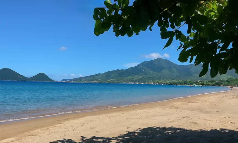
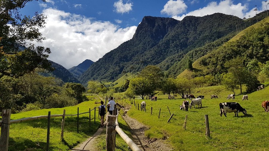
Picture this: you’re standing on a cobblestone street lined with candy-colored colonial houses, each one painted in shades of sunshine yellow, electric blue, and fiery orange. The air smells like freshly brewed coffee mixed with the earthy scent of rain on mountain soil. Behind you, the Andes Mountains rise up like sleeping giants, and somewhere in the distance, the world’s tallest palm trees are swaying in the breeze like nature’s own skyscrapers. Welcome to Salento, Colombia—a tiny mountain town that punches way above its weight when it comes to charm, adventure, and pure travel magic. Whether you’re a solo traveler looking for your next adventure, a family planning a holiday that combines nature and culture, or just someone who wants to escape the noise of everyday life, Salento has something special waiting for you. This isn’t your typical tourist trap. Sure, everyone knows about the famous wax palms in Valle de Cocora, but what to do in Salento Colombia goes far beyond that single (admittedly spectacular) experience. In this guide, I’ll walk you through 10 unforgettable experiences that showcase the real heart of this Salento Colombia coffee region gem. From hiking cloud forests to sipping coffee straight from the farm, exploring hidden waterfalls, and even learning a quirky local game involving gunpowder (yes, really!), you’re about to discover why Salento should be at the top of your Colombia bucket list. Quick Information Table Category Details Best Time to Visit December to March (dry season) or June to August Recommended Stay 3-4 days for full experience; 2 days minimum Main Activities Hiking, coffee tours, viewpoints, day trips Getting There Fly to Pereira or Armenia, then 1-hour bus ride Budget Range $30-60 USD per day (mid-range traveler) Ideal For Solo travelers, families, nature lovers, coffee enthusiasts Language Spanish (basic English in tourist areas) Safety Level Very safe for tourists, including solo travelers Planning Your Salento Adventure: Getting There & Orienting Yourself How to Reach Salento Getting to Salento is easier than you might think, though it does require a bit of planning. The town sits in Colombia’s Coffee Triangle (Eje Cafetero), nestled between the larger cities of Armenia and Pereira. By Air: Your best bet is flying into either Matecaña International Airport in Pereira (45 minutes away) or El Edén International Airport in Armenia (30 minutes away). [Cite Source: Colombian Civil Aviation Authority]. From there, you’ll hop on a local bus or arrange a private transfer. Buses run regularly throughout the day and cost around 8,000-10,000 Colombian pesos (roughly $2-3 USD). By Bus: If you’re coming from Bogotá, expect a scenic 8-10 hour bus journey through the mountains. From Medellín, it’s about 6-7 hours. Companies like Expreso Bolivariano and Expreso Palmira offer comfortable overnight buses with reclining seats. [Cite Source: Terminal de Transporte websites] Pro Tip for Solo Travelers: The bus terminals in Pereira and Armenia are safe, but arrive during daylight hours if possible. Keep your valuables close and use official taxi services or apps like DiDi or InDriver for the final leg to Salento. Orienting Yourself in Town Salento is wonderfully compact—you can walk from one end to the other in about 15 minutes. The heart of town is the Plaza de Bolívar, surrounded by restaurants, artisan shops, and cafés. From the plaza, Calle Real (also called Carrera 6) is the Instagram-famous street lined with colorful colonial architecture that climbs uphill toward the Mirador Alto de la Cruz. The Mirador Salento Colombia view is worth the 240-step climb. You’ll get panoramic views of the valley below, with the wax palms of Cocora visible on clear days. Go at sunset for the most dramatic lighting—the golden hour turns those colorful buildings into something out of a storybook. Best Time to Visit Salento Colombia Timing matters in the mountains. Salento has two dry seasons: December through March and June through August. These months offer the clearest skies for hiking the Cocora Valley wax palms trail and exploring surrounding nature. That said, this is the cloud forest—rain is part of the charm. Even during “dry” season, afternoon showers are common. The rainy seasons (April-May and September-November) bring lush green landscapes and fewer crowds, though trails can get muddy. Weekend vs. Weekday: Salento gets packed with Colombian tourists on weekends and holidays. If you’re looking for a quieter experience, visit mid-week. You’ll have trails more to yourself and won’t wait in line for jeeps to Cocora Valley. Where to Stay Accommodation options range from $10 USD hostel dorms to $80+ boutique hotels. For solo travel Salento Colombia adventures, try hostels like The Plantation House or La Serrana Eco Farm Hostel—both are social spots perfect for meeting other travelers. Families might prefer places like Hotel Salento Real or Casa de las Palmas, which offer private rooms with mountain views. The Magnificent Outdoors: Salento’s Must-Do Nature Experiences Hiking the Legendary Valle de Cocora Let’s be honest—the Cocora Valley wax palms are the main reason most people come to Salento, and they absolutely live up to the hype. These towering Quindío wax palms (Ceroxylon quindiuense) are Colombia’s national tree and the tallest palm species on Earth, reaching heights of up to 200 feet. Seeing them rising out of the misty valley feels like stepping onto another planet. The Hiking Options: There are two main ways to experience Valle de Cocora: 1. The Full Loop (5-6 hours): This 14-kilometer trail takes you through cloud forest, across rickety wooden bridges, past rushing rivers, and finally into the valley where the palms stand like natural monuments. The route is moderately challenging with some steep sections and stream crossings. [Cite Source: Colombian National Parks Service] Is the hike in Cocora Valley hard? I’ll be straight with you—it’s not a walk in the park, but it’s totally doable for anyone with average fitness. The elevation (you’ll be between 2,400-2,800 meters above sea level) might leave you breathing harder than usual. Wear good hiking boots, bring rain gear, and pack snacks and water. 2. The Short Walk (1-2 hours): If you’re short
What to Do in Salento, Colombia: 10 Unforgettable Experiences Beyond the Wax Palms Read More »