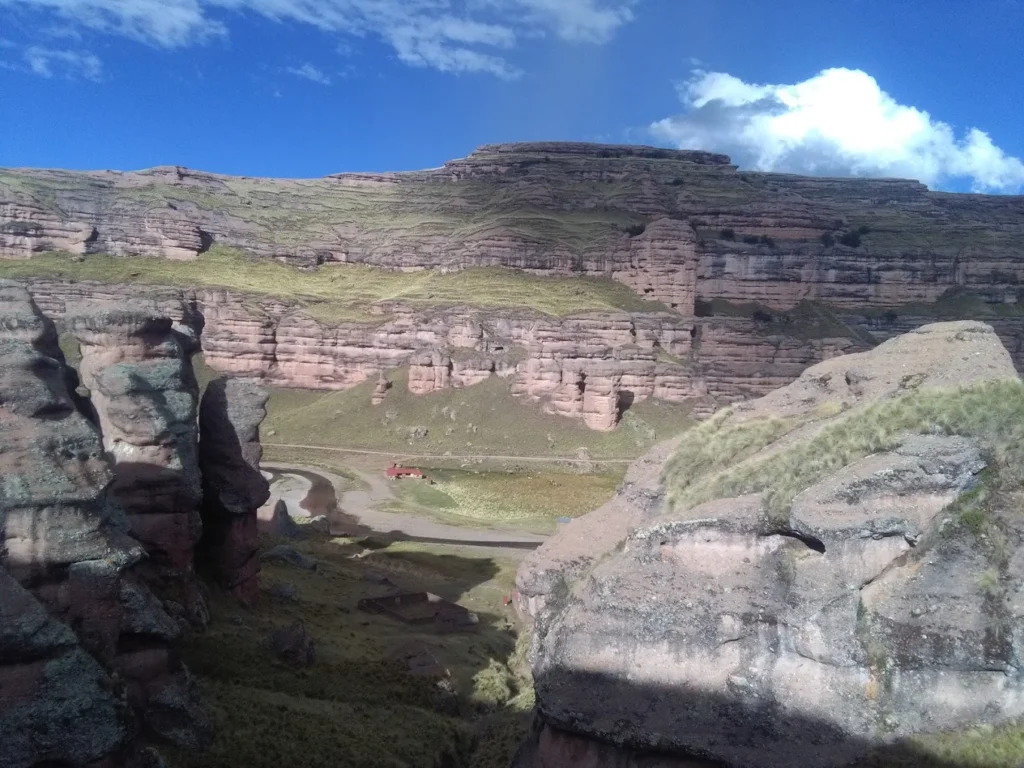
When I first heard about Tinajani Canyon Peru from local guides during my years organizing tours across the Andes, I knew this was one of those rare destinations that could genuinely surprise even seasoned travelers. Imagine towering red rock formations reaching 50 meters into the sky, sculpted over millions of years into shapes that look like frozen giants—some say they resemble castles, others see sphinxes, and a few swear they spot turtles or monks in stone. This is the Valley of Stone Giants, a geological wonder hiding in plain sight just 150 kilometers north of Puno, yet known to only a fraction of Peru’s visitors.

In my experience managing tours through Peru’s highlands, Tinajani Canyon stands out as the perfect detour for travelers seeking authentic Andean experiences without the crowds that flock to Lake Titicaca or Machu Picchu. The canyon sits at a serious elevation—between 3,895 to 4,059 meters above sea level—so proper acclimatization isn’t optional, it’s essential. But for those who take the time to prepare, this remote corner of the Puno region rewards visitors with otherworldly landscapes, rich Quechua and Aymara cultural significance, and the kind of silence you can only find in Peru’s most untouched places.
🏔️ What Is Tinajani Canyon Peru?
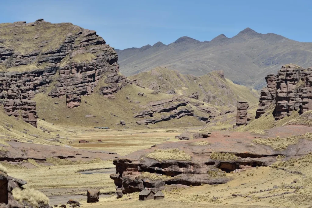
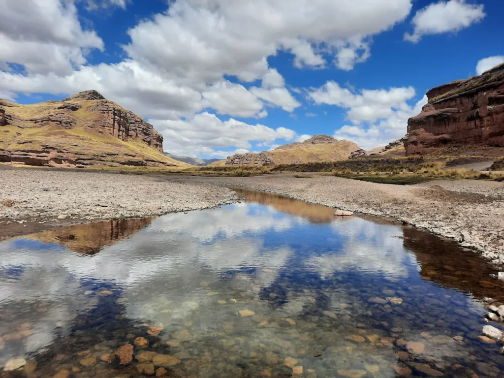
Tinajani Canyon Peru is a geological formation in the Melgar province of the Puno region, characterized by massive red sandstone towers and ravines carved by wind and water erosion over millions of years. The canyon covers approximately 200-250 hectares and sits at an elevation ranging from 3,895 to 4,059 meters (12,779 to 13,317 feet) above sea level.
The name “Tinajani” comes from the Quechua word “tinaja” (meaning pot or jar), referring to the peculiar jar-like shapes of some rock formations. Locals also call it the “Devil’s Canyon” (Cañón del Diablo) due to ancient legends about supernatural forces dwelling among the rocks.
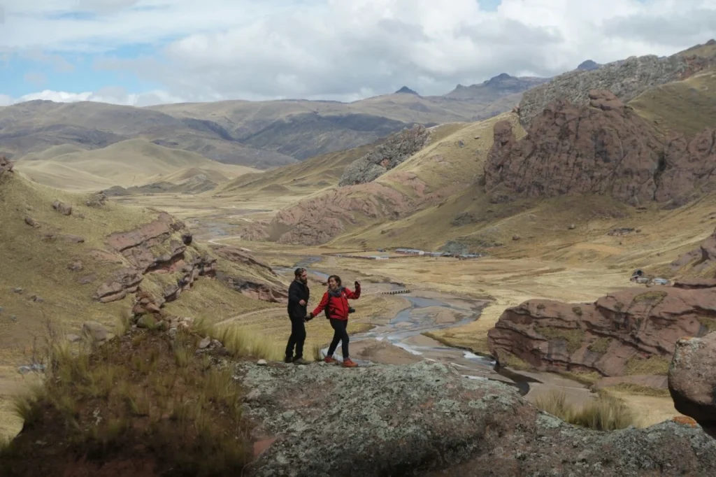
Located just 12-14 kilometers southeast of Ayaviri in the Melgar province, the canyon is divided into three main ravines: Queñuacuyo, Pacobamba, and Huarachani. The Pacobamba River flows through the canyon with crystal-clear waters, creating a sharp contrast against the rust-colored sandstone walls.
| Quick Reference: Tinajani Canyon Basics | |—|—| | Location | Melgar Province, Puno Region, Peru | | Distance from Puno | 150 km north | | Distance from Ayaviri | 12-14 km southeast | | Elevation | 3,895-4,059 m (12,779-13,317 ft) | | Area Coverage | 200-250 hectares | | Main River | Pacobamba River | | Rock Type | Red sandstone | | Alternative Names | Valley of Stone Giants, Devil’s Canyon |
🌍 Geological & Natural Overview
🗿 How Was Tinajani Canyon Formed?
From conversations with local geologists during tour planning sessions, I’ve learned that Tinajani Canyon’s origin story reads like a geological thriller. Millions of years ago, this entire region sat beneath an ancient lake called Lake Ballivián—a predecessor to Lake Titicaca and Lake Poopó. Red sandstone sediments accumulated on this lake bed over countless millennia, layer upon patient layer.
Then came the dramatic plot twist: volcanic activity and tectonic movements lifted these sedimentary deposits high into the Andes. As the climate shifted and the ancient lake dried up, the exposed sandstone faced a new sculptor—wind. Combined with freeze-thaw cycles, seasonal rains, and the relentless Andean winds, erosion carved the soft sandstone into the formations we see today.
This process continues even now. Every rainy season, every windstorm subtly reshapes the canyon’s profile, meaning the Tinajani you visit today will be slightly different from the one visitors see a decade from now.
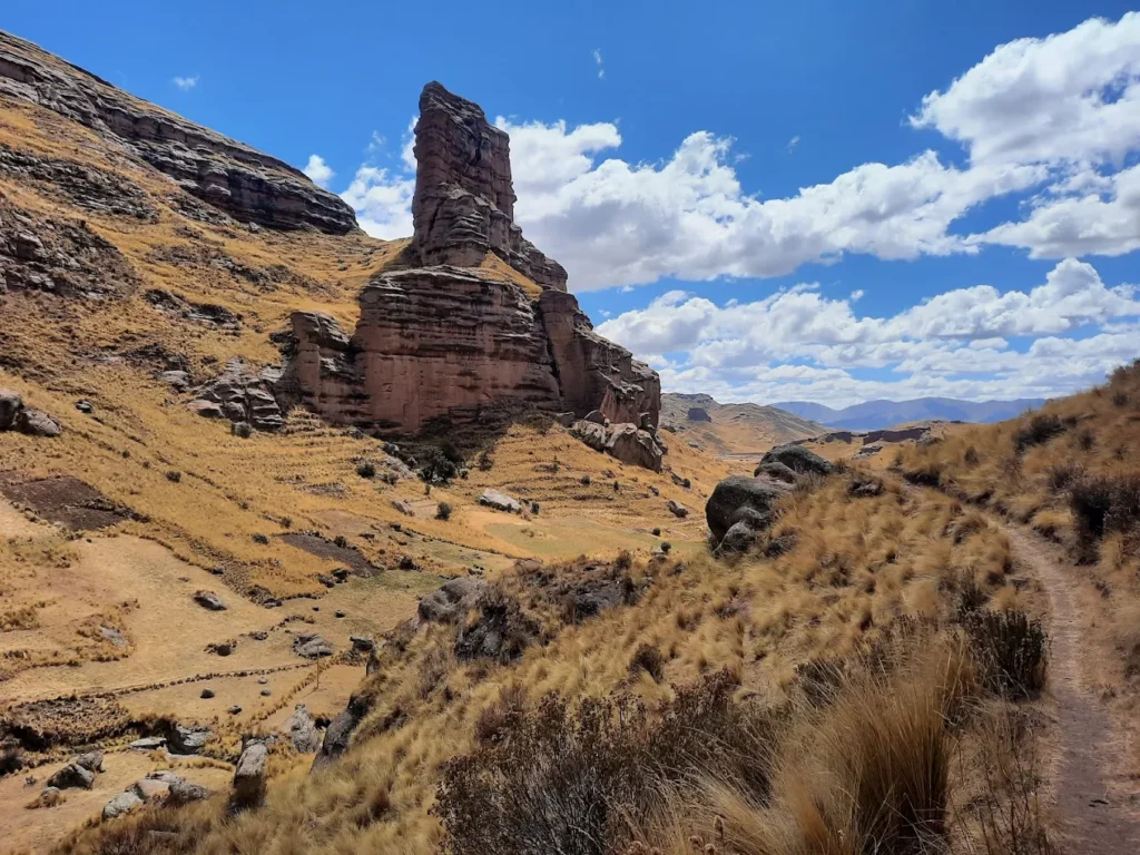
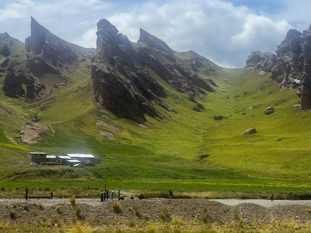
🏛️ Rock Formations & “Valley of Stone Giants”
The star attractions are undoubtedly the towering rock spires, some reaching heights of 50 meters or more. Walking among these giants, you feel small—in the best way possible. I’ve watched countless travelers stop mid-stride, cameras forgotten, just staring up at formations with names like El Vigía (The Watchman), The Friar, The Castle, and The Turtle.
The characteristic reddish-orange hue comes from iron oxide in the sandstone, and the color intensity changes throughout the day. At sunrise, the rocks glow soft pink. By midday, they turn burnt orange. At sunset—and this is when I always tell clients to have their cameras ready—the formations blaze copper and gold against purple shadows.
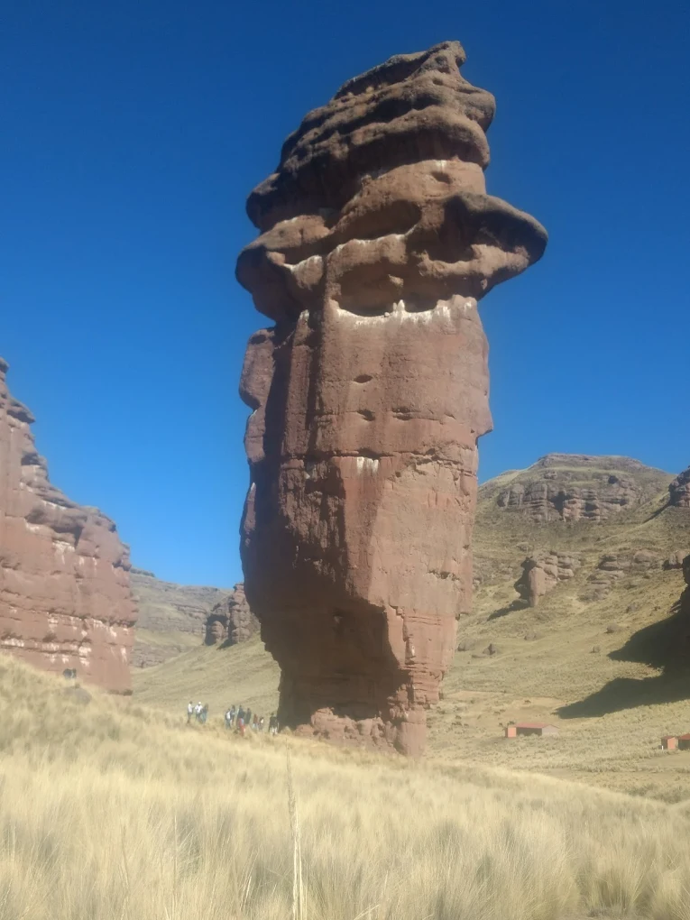
The shapes are left to your imagination. Some rocks look eerily human, others like massive animals frozen mid-movement. Anthropomorphic formations (human-shaped rocks) are common, which has fueled local legends about petrified giants.
🌿 Flora & Fauna Highlights
Despite the harsh, high-altitude environment, Tinajani Canyon supports surprising biodiversity. The star of the botanical show is the Puya Raimondii—also called the Queen of the Andes. This is the world’s largest bromeliad, and seeing one is like encountering a plant from another planet.
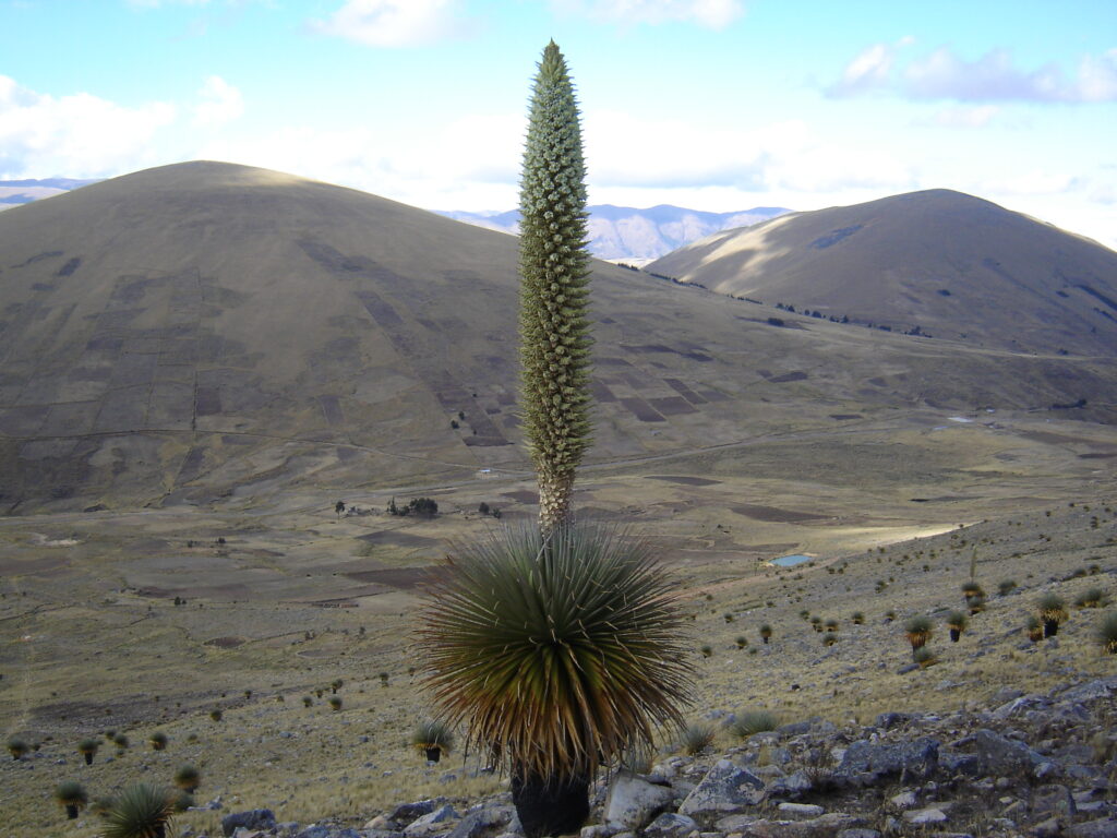
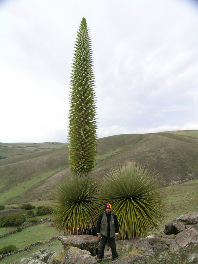
Puya Raimondii can reach heights of 10-15 meters when in bloom, producing thousands of flowers on a single spike. These ancient plants live for 60-100 years, bloom once in their lifetime, then die—a dramatic, once-in-a-century flowering event. They grow at altitudes between 3,200-4,800 meters, making Tinajani’s elevation perfect habitat.
Other vegetation includes hardy ichu grass, queñua trees (sacred in Andean culture), and various highland shrubs adapted to extreme temperature swings.
Wildlife sightings include Andean foxes, vicuñas (wild relatives of llamas), various hummingbird species (including the black metaltail hummingbird that lives among the puyas), Andean geese, and if you’re very lucky, the majestic Andean condor soaring on thermal updrafts.
⛰️ Elevation & Altitude Facts
📏 How High Is Tinajani?
Tinajani Canyon sits at elevations between 3,895 and 4,059 meters above sea level (12,779 to 13,317 feet). To put this in perspective:
- Higher than Cusco (3,399 m / 11,152 ft)
- Higher than Machu Picchu (2,430 m / 7,972 ft)
- Slightly higher than Puno (3,827 m / 12,555 ft)
- Similar to La Paz, Bolivia (3,650 m / 11,975 ft)
The main entrance and museum area typically sit around 3,913 meters, while hiking trails can take you above 4,000 meters.
🩺 Altitude Sickness (Soroche) – What You Need to Know
Here’s where my operations experience becomes critical. Altitude sickness (soroche in local Spanish) is a real concern at these heights, and I’ve seen too many travelers underestimate it.
Common symptoms include:
- Headache (often throbbing)
- Nausea and loss of appetite
- Dizziness and fatigue
- Shortness of breath
- Difficulty sleeping
- Rapid heartbeat
My recommended acclimatization strategy:
- Spend 2-3 days in Puno or Cusco first – Don’t fly from Lima (sea level) and head straight to Tinajani
- Take it slow – No vigorous activity for the first 24-48 hours at altitude
- Hydrate aggressively – Drink 3-4 liters of water daily
- Coca tea is your friend – Mate de coca helps many travelers; it’s available everywhere in the Andes
- Eat light, carb-rich meals – Heavy meals are harder to digest at altitude
- Avoid alcohol and caffeine initially – Both dehydrate you
- Consider medication – Acetazolamide (Diamox) helps; consult your doctor before traveling
Pro tip from years of tour planning: If you experience severe symptoms (confusion, difficulty walking, persistent vomiting), descend immediately and seek medical attention.
| Altitude Sickness Prevention Checklist | |—|—| | ✅ Acclimatize in Puno or Cusco for 2-3 days | | ✅ Drink 3-4 liters of water daily | | ✅ Chew coca leaves or drink mate de coca | | ✅ Avoid alcohol and limit caffeine | | ✅ Eat light, frequent meals (carbs are best) | | ✅ Rest well and avoid overexertion | | ✅ Pack Diamox if prescribed by your doctor | | ✅ Bring sunscreen (SPF 50+) – UV is intense at altitude |
🚗 How to Get to Tinajani Canyon Peru
This is where the adventure truly begins. Tinajani Canyon isn’t on the standard tourist circuit, which is part of its charm—but it also means getting there requires planning.
🛣️ From Puno to Tinajani (Most Common Route)
Distance: 150 km (3-3.5 hours by vehicle)
Route: Puno → Juliaca → Ayaviri → Tinajani
The journey follows the Interoceanic Highway (Route 3S), which is mostly paved and in good condition. From Ayaviri, a 14-kilometer unpaved road leads to the canyon entrance.
Transportation Options:
- Private Transport (Recommended): Hire a private car/van from Puno ($80-120 USD round trip). This gives you flexibility to stop for photos and explore at your own pace.
- Colectivos (Budget Option): Shared vans run from Puno to Ayaviri (~15-20 soles, 2.5-3 hours). From Ayaviri, hire a motorcycle taxi to the canyon entrance (~20-30 soles round trip, 20-30 minutes).
- Organized Tours: Some agencies in Puno offer full-day tours ($50-80 USD per person), including transport, guide, and sometimes lunch.
🚌 From Cusco to Tinajani (Scenic Route)
Distance: 200-220 km (4-5 hours by vehicle)
The drive from Cusco to Tinajani crosses the Cordillera de la Raya pass at over 4,300 meters, offering spectacular mountain views. Many travelers combine Tinajani with stops at Raqchi (Inca ruins) or Pukara (archaeological site).
🛤️ Road Conditions
The Puno-Ayaviri stretch is paved and well-maintained. The final 14 km from Ayaviri to Tinajani is unpaved but passable year-round in a standard vehicle (though 4WD is more comfortable, especially after rain).
Important note: There’s minimal to no cell phone reception at the canyon. Download offline maps (Maps.me or Google Maps offline) before departing.
| Getting to Tinajani: Options & Costs | |—|—| | From Puno (Private Car) | 3-3.5 hours, $80-120 USD round trip | | From Puno (Colectivo + Mototaxi) | 3-4 hours, ~35-50 soles total | | From Cusco (Private Car) | 4-5 hours, $120-180 USD round trip | | Organized Day Tour from Puno | Full day, $50-80 USD per person | | Entrance Fee | 20-25 soles ($5-7 USD) including museum |
🌤️ Best Time to Visit Tinajani Canyon
☀️ Dry Season (May–October) – RECOMMENDED
This is hands-down the best time for Tinajani Canyon. Here’s why:
- Clear skies: Perfect for photography and stargazing
- Minimal rain: Hiking trails are dry and accessible
- Stable weather: Daytime temperatures 15-19°C (59-66°F), nights -2 to 5°C (28-41°F)
- Visibility: You can see for miles across the Altiplano
- Best months: June, July, August offer the most reliable weather
Downside: This is peak tourist season in Peru (though Tinajani still sees few visitors), and nights are cold—bring warm layers.
🌧️ Rainy Season (November–April)
The landscape transforms into a “lush oasis” with green grasses carpeting the canyon floor.
Pros:
- Fewer tourists (you might have the place to yourself)
- Green scenery instead of brown
- Dramatic cloud formations
- Lower accommodation prices in Puno/Ayaviri
Cons:
- Afternoon thunderstorms are common
- Unpaved road to the canyon can be muddy
- Overcast skies limit photography
- Harder to see Puya Raimondii fields clearly
Best compromise: May or October—shoulder months with decent weather and fewer crowds.
📸 Best Time of Day for Photography
Based on what I’ve learned from professional photographers I’ve guided:
- Sunrise (6:00-7:30 AM): Soft pink light on red rocks, minimal shadows, often dead calm
- Midday (11:00 AM-2:00 PM): Harsh light, strong contrasts—good for dramatic shots
- Sunset (5:00-6:30 PM): Golden hour magic—the rocks glow copper and orange
- Night: With zero light pollution, Tinajani offers world-class stargazing
🥾 Activities & Things to Do
🚶 Hiking Trails & Views
Tinajani Canyon offers multiple trails ranging from easy walks to moderate hikes. The terrain is mostly flat to gently rolling, but the altitude makes everything more challenging.
Main Hiking Routes:
- Short Loop (1-2 hours): Easy walk through the main formations, suitable for all fitness levels
- Medium Circuit (2-3 hours): Explores deeper into the ravines, includes Pacobamba River viewpoints
- Extended Trek (3-4 hours): Reaches higher elevations for panoramic views of the entire canyon
- Puya Raimondii Forest Walk (2-3 hours): Special route to see the giant bromeliads (seasonal, guide recommended)

Pro tip: Trails aren’t always well-marked. The local museum owner (usually Vicente) or guides can point you to constructed circuits.
🧗 Adventure Options
Rock Climbing: The sandstone formations attract climbers, though you’ll need to bring your own gear (no established routes or rental equipment on-site).
Horseback Riding: Arrange through local families in Tinajani village (~50-100 soles for 2-3 hours). Exploring the canyon on horseback feels wonderfully authentic.
Mountain Biking: The unpaved roads and trails are perfect for fat-tire bikes. The flat Altiplano terrain makes for surprisingly enjoyable (if cold) cycling.
🎭 Cultural Experiences
Ayaviri Festivals: In July, the Music and Dance Festival brings together hundreds of Andean dancers at the foot of Tinajani. This is your chance to see traditional highland culture in action.
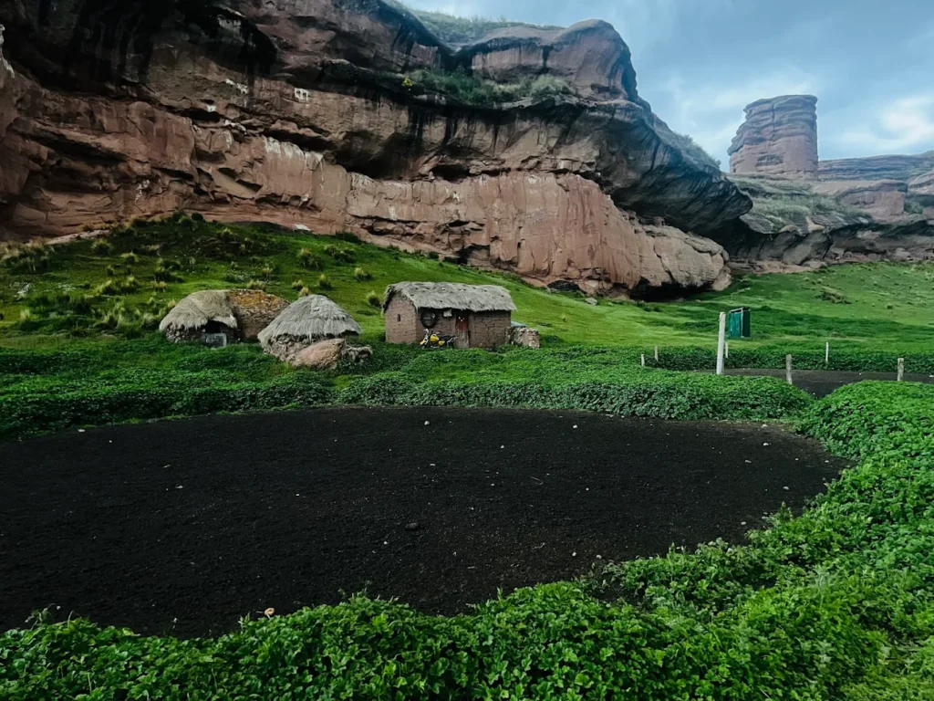
Local Communities: Engaging respectfully with Quechua-speaking families in Tinajani village offers insights into traditional Andean life—though always ask permission and consider hiring a translator/guide.
Archaeological Sites: Pre-Inca and Inca chullpas (funerary towers) dot the canyon. The Qaluyo culture once thrived here.
🏕️ Overnight Stays & Camping
Camping at Tinajani is an experience I highly recommend to adventurous clients. The campground near the museum offers basic facilities:
- Pit toilets (recently renovated)
- Natural water source (purify before drinking)
- Small shelter for bad weather
- Fee: 10-25 soles per person/night (donation-based, includes museum visit)
What to expect: No electricity, no showers, freezing nights (temperatures can drop below 0°C), but absolutely spectacular stargazing with zero light pollution. The Milky Way stretches across the entire sky.
Camping tips:
- Bring a 4-season tent and cold-rated sleeping bag (-5°C minimum)
- Pack all food and water
- Respect the “leave no trace” principle
- Ask permission from Vicente (the museum owner/caretaker)
🎒 Practical Travel Tips
From years of organizing high-altitude tours, here’s my essential packing checklist for Tinajani:
👕 Clothing (Layering is Key)
- Base layer: Thermal underwear (wool or synthetic)
- Mid layer: Fleece jacket
- Outer layer: Windproof/waterproof jacket
- Pants: Long trekking pants (avoid jeans—they don’t dry)
- Hat: Warm beanie for mornings/evenings + wide-brim sun hat for day
- Gloves: Essential for early mornings
- Sturdy hiking boots: Already broken in
Temperature swings: Expect 15-19°C (59-66°F) during the day (in sun) but -2 to 5°C (28-41°F) at night, even in the dry season.
💧 Water & Snacks
- Bring 2-3 liters of water per person
- High-energy snacks (nuts, chocolate, dried fruit, energy bars)
- Simple lunch if spending the day (no restaurants at the canyon)
- Important: There are no food facilities at Tinajani—the nearest restaurant is in Ayaviri
📱 Technology & Navigation
- Download offline maps (no cell signal)
- Portable battery pack for your phone/camera
- Sunscreen SPF 50+ and lip balm (UV is brutal at altitude)
- Sunglasses with UV protection
💊 First Aid & Essentials
- Altitude sickness medication (if prescribed)
- Ibuprofen/paracetamol for headaches
- Band-aids and blister treatment
- Hand sanitizer and toilet paper
🗓️ Itineraries
📅 Option 1: 1-Day from Puno (Most Common)
6:00 AM – Depart Puno by private vehicle
9:00 AM – Arrive Ayaviri, quick breakfast/coffee
9:30 AM – Reach Tinajani Canyon entrance
10:00 AM-3:00 PM – Explore canyon, hike trails, visit museum
3:00 PM – Lunch in Ayaviri (try cancacho)
4:00 PM – Depart for Puno
7:00 PM – Arrive Puno
Budget: $80-120 USD (private transport) or ~50 soles (colectivo + mototaxi)
📅 Option 2: Stopover En Route Cusco↔Puno (Smart Option)
Instead of the grueling 6-7 hour direct bus between Cusco and Puno, break the journey with a Tinajani stop:
Morning – Depart Cusco
Midday – Stop at Raqchi ruins (30 min visit)
Afternoon – Arrive Tinajani, explore for 2-3 hours
Late Afternoon – Continue to Puno, arrive evening
This turns a boring bus ride into a memorable adventure day.
📅 Option 3: Multi-Day Heritage Tour
Day 1: Puno → Sillustani (funerary towers) → Puno
Day 2: Puno → Lampa (colonial church) → Pukará (archaeological site) → Tinajani Canyon → Ayaviri (overnight)
Day 3: Ayaviri → Puya Raimondii forest → Return Puno
This “Quechua Circuit” tour showcases the lesser-known cultural richness of the Puno highlands.
🤔 Expert Comparison
❓ What Is the Deepest Canyon in Peru?
This is a question I get often from geology-loving clients. Cotahuasi Canyon, located in the Arequipa region, holds the title as Peru’s (and one of the world’s) deepest canyons at approximately 3,535 meters (11,595 feet) deep—twice as deep as the Grand Canyon.
However, Tinajani and Cotahuasi are completely different experiences:
| Feature | Tinajani Canyon | Cotahuasi Canyon |
|---|---|---|
| Type | Stone forest/plateau canyon | Deep vertical canyon |
| Main Attraction | Rock formations, “stone giants” | Depth, river, terraces |
| Accessibility | 3-4 hours from Puno | 12+ hours from Arequipa |
| Crowds | Very few visitors | Still off-beaten-path |
| Best For | Day trips, photography, geology | Multi-day trekking, rafting |
| Depth | Moderate ravines | 3,535 m deep (extreme) |
Tinajani offers unique rock formations rather than depth. Think of it as Peru’s answer to Utah’s canyon country—red rocks, bizarre shapes, high-desert beauty.
❓ FAQs — Real Travel Queries Answered
Is Tinajani Canyon worth visiting?
Absolutely, yes—especially if you’re already in Puno and looking for something beyond Lake Titicaca. The rock formations are genuinely unique in Peru, the crowds are minimal, and the cultural richness is authentic. It’s perfect for travelers seeking off-the-beaten-path adventures.
Can you visit Tinajani from Cusco?
Yes, though it’s 4-5 hours each way. I recommend combining it with an overnight in Ayaviri or Puno, or making it a stopover between Cusco and Puno. Don’t attempt it as a day trip from Cusco—that’s 8-10 hours of driving in one day.
How long is the drive from Puno to Tinajani?
3 to 3.5 hours by private vehicle (150 km). Add 30-60 minutes if using public colectivos (waiting time + transfers in Ayaviri).
Is phone reception available at Tinajani Canyon?
No. There’s essentially no cell signal at the canyon. Download offline maps and let your accommodation in Puno know your plans.
Is Tinajani family-friendly?
Yes, with caveats. The trails are moderate difficulty, but the altitude (nearly 4,000 m) is challenging for everyone, especially children. Make sure kids are well-acclimatized first. Pack plenty of snacks and water. Older children (8+) generally handle it well.
Do you need a guide for Tinajani Canyon?
Not mandatory, but recommended. Guides help interpret the geology, point out Puya Raimondii, share legends, and navigate unmarked trails. The museum owner/caretaker often offers informal guiding (tip-based). Or hire a guide from Puno ($30-50 USD for the day).
🍽️ Local Cuisine & Culture
🥩 Cancacho – Ayaviri’s Signature Dish
After a morning exploring Tinajani, there’s a local tradition I never skip: cancacho in Ayaviri. This is roasted and marinated lamb, slow-cooked until the meat falls off the bone, seasoned with Andean herbs and spices.
Where to try it: Small restaurants (“picanterías“) around Ayaviri’s main plaza serve cancacho with potatoes and salsa criolla (onion relish). Expect to pay 15-25 soles ($4-7 USD) for a generous portion.
🍵 Other Andean Foods
- Trucha (trout): Freshwater fish from local rivers
- Quinoa soup: Hearty and high in protein
- Ch’uño: Freeze-dried potatoes (an ancient Inca preservation method)
- Mate de coca: Coca leaf tea—sip it throughout the day
🎭 Cultural Etiquette
When interacting with local Quechua communities:
- Always ask permission before photographing people
- Learn basic Quechua greetings: “Allillanchu” (hello), “Yupaychani” (thank you)
- Respect sacred sites: The rocks are considered apus (mountain spirits/protectors)
- Tip guides and drivers fairly (10-15% is standard)
- Buy local crafts directly from artisans when possible
🌿 Safety & Responsible Tourism
⚠️ Safety Considerations
Tinajani is generally very safe, but high-altitude environments demand respect:
- Monitor altitude sickness symptoms constantly
- Stay on trails—sandstone can be fragile
- Bring warm clothes—hypothermia is a real risk
- Travel in groups if possible (or inform someone of your plans)
- Watch for loose rocks when scrambling on formations
Emergency contacts:
- Ayaviri Health Center: +51 51 563 006
- Puno Regional Hospital: +51 51 363 031
- Peru Emergency (Police): 105
♻️ Leave No Trace Principles
Tinajani Canyon has no formal waste management. Everything you bring in, you must pack out.
- Carry all trash with you (including toilet paper)
- Use existing campsites—don’t create new ones
- Don’t remove rocks, plants, or archaeological artifacts
- Respect the apu (mountain spirits)—locals consider these formations sacred
- Use the designated toilet facilities at the museum/campground
🙏 Respecting the “Apu”
In Quechua and Aymara cosmology, Tinajani’s rock formations are apus—sacred mountain spirits that protect the land and people. When visiting:
- Approach the canyon with reverence
- Don’t climb on sacred formations (ask your guide which are significant)
- Consider participating in a small offering ceremony (ask local guides)
- Never deface or graffiti the rocks
🎯 Conclusion
Tinajani Canyon Peru is one of those rare destinations that stays with you long after you’ve left. The red rock towers, the silence broken only by Andean winds, the star-filled nights, the warm cancacho in Ayaviri afterward—these moments combine to create something truly special.
In my 20 years organizing travel experiences across Peru, I’ve learned that the best adventures often lie just beyond the guidebook circuit. Tinajani is exactly that kind of place. It rewards curiosity, respects those who take time to acclimatize properly, and offers both spectacular geology and deep cultural meaning.
Whether you visit for a day trip from Puno, camp overnight under infinite stars, or make it a stopover between Cusco and Lake Titicaca, Tinajani Canyon will show you a Peru that few travelers ever see.
Ready to explore the Valley of Stone Giants? Start planning your acclimatization in Puno, pack your layers, download your offline maps, and prepare for an Andean adventure that combines natural wonder with authentic cultural immersion.
Questions about planning your Tinajani Canyon adventure? Contact us at Astamb Holidays (https://www.linkedin.com/in/wahid-ali-2aa84022/) or visit XploreHeaven.com for more hidden gem travel guides across India and beyond!
Safe travels, and remember—take only photos, leave only footprints, and always respect the apus.
📚 References & Citations
This article is backed by authoritative sources and research:
- Inca Trail Machu (2025). “The Tinajani Canyon, one of the hidden wonders of Puno.” Retrieved from: https://www.incatrailmachu.com/en/travel-blog/tinajani-canyon-peru
- Salkantay Trek Machu (2025). “The Tinajani canyon of Puno.” Retrieved from: https://www.salkantaytrekmachu.com/en/travel-blog/tinajani-canyon-of-puno
- Clark Kotula Travel (2025). “Tinajani — A New Andean Property.” Retrieved from: https://www.clarkkotula.com/tinajani
- Viajes Machu Picchu Travel (2025). “Tinajani Canyon Tour: An Authentic Scenery Awaits.” Retrieved from: https://viajesmachupicchu.travel/en/destinations/puno/tours/tinajani-canyon-tour
- Tierra Viva Hotels (2019). “The Tinajani Canyon, One of the Hidden Wonders of Puno.” Retrieved from: https://tierravivahoteles.com/en/the-tinajani-canyon-one-of-the-hidden-wonders-of-puno/
- iOverlander (2025). “Tinajani Canyon Campground — Established Campground.” Retrieved from: https://ioverlander.com/places/a10c3748-1271-44e1-bf53-7dd9af7fef36
- Machu Picchu Sacred (2025). “Tinajani Canyon in Puno.” Retrieved from: https://machupicchusacred.com/en/puno/tourist-attractions/tinajani-canyon/
- Natura Tourism (2025). “Canyon Tinajani.” Retrieved from: https://naturatourism.com/en/canyon-tinajani/
- Globetrender (2025). “Peru’s Tinajani is a tented canyon retreat with private hot tubs.” Retrieved from: https://globetrender.com/2025/08/22/perus-tinajani-is-a-tented-canyon-retreat-with-private-hot-tubs/
- Tierras Vivas (2025). “The Tinajani Canyon, One of the Hidden Wonders of Puno.” Retrieved from: https://www.tierrasvivas.com/en/travel-blog/tinajani-canyon-peru
- Wikipedia (2025). “Puya raimondii.” Retrieved from: https://en.wikipedia.org/wiki/Puya_raimondii
- Frontiers in Conservation Science (2024). “Queen of the Andes: the ecology and conservation of Puya raimondii.” Retrieved from: https://www.frontiersin.org/journals/conservation-science/articles/10.3389/fcosc.2024.1349553/full
- Viagens Machu Picchu Blog (2025). “Meet the Puya de Raimondi.” Retrieved from: https://blog.viajesmachupicchu.travel/en/puya-de-raimondi-exploring-the-andes-giant-plant/
- Wikipedia (2025). “Cotahuasi Canyon.” Retrieved from: https://en.wikipedia.org/wiki/Cotahuasi_Canyon
- Peru For Less (2025). “Cotahuasi Canyon: Explore The World’s 3rd Deepest Canyon.” Retrieved from: https://www.peruforless.com/blog/cotahuasi-canyon
- Atlas Obscura (2025). “Cotahuasi Canyon.” Retrieved from: https://www.atlasobscura.com/places/cotahuasi-canyon
- Odynovo Tours (2025). “Peru Altitude Sickness: How to Avoid and Treat It.” Retrieved from: https://www.odynovotours.com/travel-blog/peru-altitude-sickness.html
- Leading Peru Travel (2025). “A 6-Step Guide to Enjoying High Altitude in Peru.” Retrieved from: https://leadingperutravel.com/blog/altitude-sickness-in-peru
- Exploor Peru (2025). “Altitude Sickness in Peru Guide: Symptoms & Prevention.” Retrieved from: https://exploorperu.com/blog/peru/altitude-sickness-all-you-need-to-know-and-how-to-avoid-it/
- Clark Kotula (2024). “What’s the Deal with Altitude Sickness in Peru, and How to Avoid It?” Retrieved from: https://www.clarkkotula.com/blog/2019/4/23/whats-the-deal-with-altitude-sickness-in-peru-and-how-to-avoid-it
About the Author:
Wahid Ali is a seasoned travel professional and operations lead in the tourism industry with extensive experience in crafting travel experiences and destination insights. Based in Mumbai, he heads operations at Astamb Holidays, where he combines practical travel logistics expertise with engaging storytelling to help travelers explore hidden gems across India and beyond. His work blends expert travel planning with a passion for culturally rich and nature-oriented destinations.
Connect with Wahid: LinkedIn Profile
Related Articles You Might Enjoy:
- Bali Travel Guide 2026: Best Places, Itinerary, Budget & Hidden Gems (Complete Planner)
- Alleppey Tourist Places: 25 Best Places to Visit in Alleppey Backwaters (2026 Travel Guide)
- Munnar Tourist Places: 20 Best Places to Visit in Munnar, Tea Gardens, Itinerary & Hidden Gems (2026 Travel Guide)
- Is Sardinia Worth Visiting? Complete Travel Guide to Sardinia, Italy
- What to Do in Gozo: 25 Best Things to Do in Gozo Malta (Hidden Gems + Local Tips)
Follow XploreHeaven.com for more authentic travel guides to hidden destinations around the world!