United States Travel

Explore United States travel guides, itineraries, places to visit, road trips, travel tips, and destination insights for popular cities, national parks, and attractions across the USA.

Yosemite National Park Travel Guide 2026: Best Things to Do, Itinerary & Travel Tips

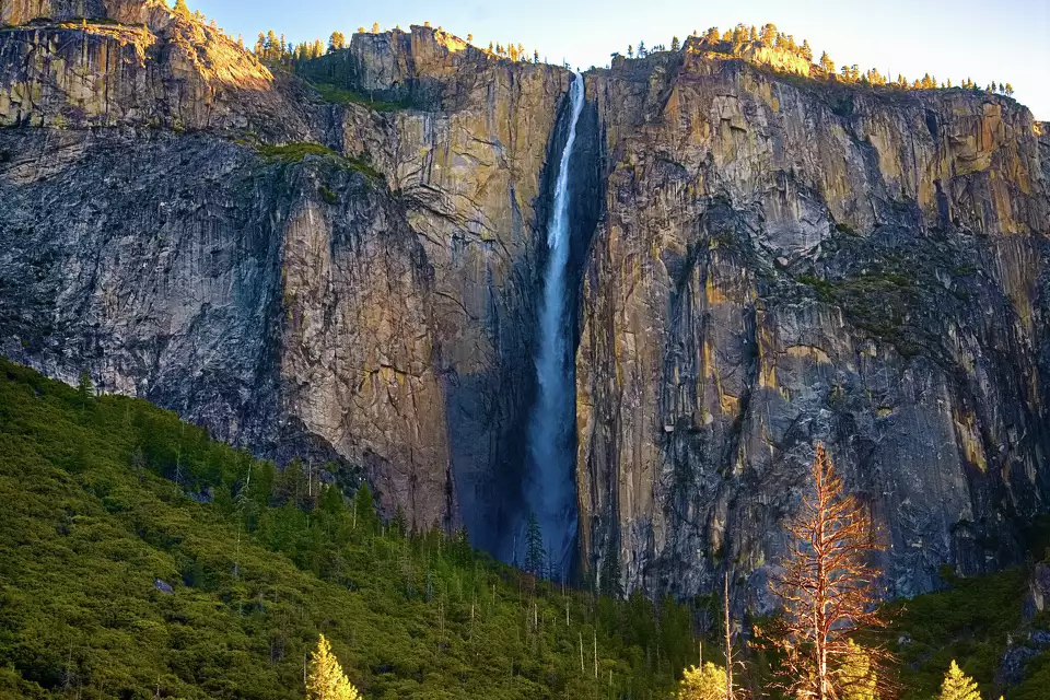
By Wahid Ali | Operations Lead, Astamb Holidays, Mumbai | LinkedIn | Published on xploreheaven.com I’ve helped plan trips to some of the most jaw-dropping places on the planet — from the backwaters of Kerala to the glaciers of Patagonia. But when clients ask me about a single destination that stops people in their tracks the moment they arrive, I always say Yosemite National Park. There’s nothing quite like your first look at that valley. The air feels different. Time slows down. And your phone suddenly feels completely irrelevant. This guide is built from real industry experience, updated research, and a genuine love for helping travelers get the most out of every hour they spend in Yosemite National Park. Whether you’ve got one day or one week, I’ve got your plan sorted — with all the 2026 updates you need, honest crowd advice, and the kinds of tips that don’t make it into mainstream travel lists. 🏔️ Why Is Yosemite National Park So Famous? Yosemite National Park is famous for its sheer granite cliffs, thundering waterfalls, ancient giant sequoia forests, and some of the most dramatic valley scenery on Earth. Located in California’s Sierra Nevada mountains, it covers 748,000 acres and welcomes roughly 4 to 5 million visitors every year. The park was recognized as a UNESCO World Heritage Site in 1984 — a designation that acknowledges its outstanding universal value both as a natural landscape and an ecological habitat. But honestly, you don’t need a UNESCO label to feel the magic. Stand at Tunnel View for the first time and the granite walls just speak for themselves. What makes Yosemite truly special is the combination of scale and accessibility. Within just a few miles, you can look up at El Capitan — a vertical granite wall rising 3,000 feet from the valley floor — and then stroll through a peaceful meadow where deer graze without paying you any attention at all. Half Dome, the park’s most iconic rock formation, rises 8,839 feet above sea level. It draws hikers, climbers, and photographers from all over the world. Yosemite Falls, one of North America’s tallest waterfalls, drops 2,425 feet in a spectacular three-tiered cascade best seen in spring. And then there’s Mariposa Grove, home to nearly 500 giant sequoias, some over 2,000 years old. In my two decades in travel, I’ve noticed that Yosemite has a rare quality — it moves people emotionally in a way that very few places do. Clients come back from their first visit and tell me it changed something in them. I believe it. 🗺️ Getting to Yosemite — Location & Logistics Where Is Yosemite National Park? Yosemite National Park sits in east-central California, straddling the western slopes of the Sierra Nevada. The main hub is Yosemite Valley, located in the western part of the park. Distances from Major Cities Departure City Distance to Yosemite Valley Drive Time (Approx.) San Francisco, CA ~170 miles 3.5 – 4 hours Los Angeles, CA ~310 miles 5.5 – 6.5 hours Las Vegas, NV ~385 miles 6 – 7 hours Sacramento, CA ~165 miles 3 – 3.5 hours San Jose, CA ~150 miles 3 – 3.5 hours Nearest Airports Best Driving Routes Pro Tip from Wahid: Download Google Maps offline before you leave your gateway city. Cell signal disappears well before you reach the park boundary. I’ve seen travelers standing at a junction with zero bars and no idea which way to turn. Don’t be that person. Public Transportation Options The Yosemite Area Regional Transportation System (YARTS) runs buses from gateway towns including Merced, Sonora, Mariposa, and Mammoth Lakes directly into Yosemite Valley. This is genuinely one of the best ways to visit in 2026, especially with no reservation system in place. Less parking stress, more scenery. Once inside the park, the free Yosemite Valley Shuttle runs year-round between major stops in the valley. It’s efficient, reliable, and saves you the headache of looking for parking at trailheads. 📅 When to Visit Yosemite — Seasonal Planning What Is the Best Time to Visit Yosemite? The best time to visit Yosemite National Park depends on your priorities. Spring (April–June) offers peak waterfall flow and wildflowers. Summer (July–August) gives full trail access but maximum crowds. Fall (September–November) brings golden colors and quieter trails. Winter (December–March) is magical with snow but comes with road closures. Season-by-Season Breakdown 🌸 Spring (April – June) This is, without a doubt, my personal favorite time to visit. The waterfalls are absolutely roaring from snowmelt — Yosemite Falls, Bridalveil Fall, and Vernal Fall are at their dramatic best. Wildflowers carpet the meadows. And while Memorial Day weekend gets busy, most of April and May are still manageable. ☀️ Summer (July – August) Summer is peak season, plain and simple. Every trail is open, the weather is warm and reliable, and families are out in full force. But it’s also the time when parking lots fill by 8 AM and trailheads feel like airport terminals. 🍂 Fall (September – November) If I had to recommend one season for solo travelers and photographers, it would be fall. The crowds thin out noticeably after Labor Day. The light turns golden and gorgeous. Black oaks and bigleaf maples put on a brilliant color show in October. ❄️ Winter (December – March) Yosemite in winter is breathtaking in a completely different way. Snow-dusted Half Dome, frozen waterfalls, and nearly empty trails create an almost surreal atmosphere. Badger Pass Ski Area offers skiing and snowshoeing. Best Season Based on Traveler Type Traveler Type Best Season Why Families with kids Summer (June–Aug) All trails open, warm weather, full facilities Serious hikers Spring or Fall Cooler temps, fewer crowds, better conditions Photographers Spring & Fall Peak waterfall flow + golden foliage + soft light Budget travelers Fall & Winter Off-peak rates, fewer people Snow & Winter lovers Dec–Feb Snowpack, skiing at Badger Pass, Firefall event First-time visitors May or September Good balance of access, weather, and crowd levels Wildlife watchers Spring & Fall Most active

Yosemite National Park Travel Guide 2026: Best Things to Do, Itinerary & Travel Tips Read More »
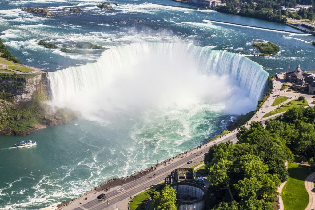
How Niagara Falls Was Formed: Geological Story, Hidden History & What It Means Today

Ever wondered what it would look like to see a river carve through solid rock? That’s exactly the story of Niagara Falls—a spectacular tale of ice, water, and time that began over 12,000 years ago. Standing at the edge of this thundering cascade, you’re witnessing one of nature’s most incredible construction projects, where how Niagara Falls was formed involves a perfect storm of geological forces that continue shaping our world today. This isn’t just another tourist attraction story. The formation of Niagara Falls is a masterclass in geological drama, featuring massive ice sheets, ancient buried valleys, and a recipe of rock layers that created the perfect conditions for one of the world’s most famous waterfalls. By understanding this incredible journey, you’ll discover how glacial melting, the birth of the Great Lakes, and the unique Niagara Escarpment combined to create this natural wonder that continues evolving before our eyes. Based on well-documented geological findings from leading institutions, this story will take you on a 12,000-year journey that transforms how you see this iconic waterfall forever. Quick Information Table Formation Details Information Age of Niagara Falls Approximately 12,000 years old Formation Period End of last Ice Age (Wisconsin Glaciation) Primary Formation Process Glacial meltwater erosion over Niagara Escarpment Key Rock Layers Lockport Formation (hard caprock) over Rochester/Queenston Formation (soft shale) Current Retreat Rate About 1 foot per year (reduced from 3-5 feet due to hydroelectric diversions) Total Gorge Length 7 miles from Lewiston to current falls location Height of Falls 167 feet (Horseshoe Falls), 70 feet (American Falls) Water Source Great Lakes drainage system via Niagara River Future Projection Will reach Lake Erie in approximately 50,000 years Daily Water Flow 6 million cubic feet per minute (peak flow) The Ancient Landscape: A World Covered in Ice Picture this: 20,000 years ago, where Niagara Falls now thunders, there was nothing but ice. Lots of ice. The massive Wisconsin Glacier, part of the last great Ice Age, stretched across most of northeastern North America like a frozen blanket up to two miles thick. This wasn’t just any ordinary ice sheet—it was a geological bulldozer that completely reshaped the landscape beneath it. The Wisconsin Glacier did more than just cover the land. As it slowly crept across the region, it carved deep valleys, scraped away hilltops, and completely rearranged the drainage patterns that had existed for millions of years. One of the most fascinating discoveries in understanding how Niagara Falls was formed is the Saint David’s Buried Gorge—a “ghost river” valley that the glacier filled with debris and sediment. This ancient valley, now hidden beneath layers of glacial deposits, tells us that water was carving paths through this landscape long before our modern Niagara River existed. The glacier essentially hit the reset button on the entire region’s geography, setting the stage for something completely new to emerge once the ice began its final retreat. The sheer weight of this ice sheet also pressed down on the Earth’s crust, causing the land to sink. This geological process, called isostatic depression, would later play a crucial role in shaping the Great Lakes and the drainage patterns that would eventually create the Niagara River. A New Beginning: The Ice Melts and a Mighty River Awakens Around 12,000 years ago, the climate began to warm, and the Wisconsin Glacier started its dramatic retreat. But this wasn’t a gentle melting process—it was an explosive geological event that released unimaginable amounts of water across the landscape. Imagine trying to drain a bathtub the size of several states all at once. That’s the scale of glacial melting that reshaped this region. As the massive ice sheet melted, it created temporary lakes, raging rivers, and floods that would make today’s most extreme weather events look like gentle spring showers. The meltwater had to go somewhere, and it began filling the deep basins that the glacier had carved during its advance. These basins would become what we now know as the Great Lakes—Erie, Ontario, Huron, Michigan, and Superior. The formation of these Great Lakes created an entirely new drainage system. Water from the upper Great Lakes now needed to flow toward the Atlantic Ocean, and the most direct route was through the newly formed connection between Lake Erie and Lake Ontario. This connection became the Niagara River, born from the Great Lakes drainage system that the glacier had inadvertently designed. Here’s where the story gets interesting: this new Niagara River needed to find its way from the higher elevation of Lake Erie (about 571 feet above sea level) down to Lake Ontario (about 245 feet above sea level). That 326-foot elevation difference meant the water would flow with tremendous force—but where exactly it would flow depended on what kind of rock it encountered along the way. The Niagara Escarpment: Nature’s Perfect Recipe for a Waterfall Think of the Niagara Escarpment as a giant layer cake made of different kinds of rock, each with its own personality when it comes to dealing with flowing water. This ancient cliff face, formed hundreds of millions of years ago, stretches for hundreds of miles through Ontario, New York, Wisconsin, and Michigan. But it’s here at Niagara where it created the perfect conditions for a spectacular waterfall. The “frosting” on this geological layer cake is the Lockport Formation—a tough, hard layer of limestone and dolomite that geologists call caprock. This rock formed about 430 million years ago when this area was covered by a warm, shallow sea. The limestone is incredibly resistant to erosion, which means water has a tough time wearing it away. It’s like nature’s concrete, holding firm against the pounding of millions of gallons of water. Beneath this hard caprock lies the “cake” itself—softer rock layers, particularly the Rochester Formation, made up of shale and other sedimentary rocks. These softer layers are like geological butter compared to the limestone frosting above them. When water hits these rocks, they crumble and wash away relatively easily. The Queenston Formation, even deeper in this rock layer cake, consists

How Niagara Falls Was Formed: Geological Story, Hidden History & What It Means Today Read More »

six flags america

Conquer Six Flags America: A Thrilling Guide to Rides, Entertainment, and More!

Imagine stepping into a world where adrenaline surges with every twist and turn—where iconic coasters, immersive attractions, and family-friendly adventures await at every corner. Welcome to Six Flags America, a powerhouse of thrills nestled in Maryland near Washington, D.C. Originally emerging from a humble wildlife preserve in 1974 and evolving through many incarnations before donning the Six Flags banner in 1999, this park has long been a destination for both hardcore thrill-seekers and families alike. In this ultimate guide, we set out to answer common questions—including the intriguing query, “How big is Six Flags Great America?” (even though here we focus on Six Flags America in Maryland). We’ll explore the park’s layout, highlight its record-breaking attractions, and offer insider tips to help you navigate the park’s many themed zones. Whether you’re wondering about ride details, parking logistics, or the best strategies for maximizing your day, this comprehensive post is your ticket to an unforgettable adventure. Understanding Six Flags America’s Layout and Size Aspect Details Location Six Flags America is located in Bowie, Maryland, conveniently serving visitors from both Baltimore and Washington, D.C. Its regional setting ties closely to its patriotic name and rich history. Directions By Car: Reach the park via major highways connecting Washington, D.C., and Baltimore. Clear signage directs drivers to the park’s access points.By Public Transit: Metro, bus, or rideshare services drop guests near the gate. Parking Ample parking is available on-site near the park entrance with fees typically ranging from $10 to $20 per day. Park Size & Layout The park spans a considerable acreage divided into multiple themed zones (e.g., Gotham City, Mardi Gras, Chesapeake), each offering its own unique attractions and rides. This expansive layout ensures diverse experiences for every visitor. Operating Hours & Seasons Six Flags America generally operates from April through November, with extended hours during summer and on special event days (such as Halloween’s Fright Fest). It’s advisable to check the official park calendar or mobile app for the latest schedule updates. Below is a comprehensive draft of your blog post that follows the prompt’s instructions. It covers every section—from the opening hook to the detailed FAQ—and weaves in information (with citation markers) from your provided PDF. You can expand each section further as needed to reach your target word count. Thrilling Rides & Attractions 1. Thrill Rides (Roller Coasters & High-Speed Attractions) Six Flags America is renowned for its diverse mix of rides that cater to every thrill level. In this section, we break down the attractions by type and include detailed descriptions of the park’s top rides. Categorized Rides 2. Family & Kiddy Rides In addition to high-thrill attractions, Six Flags America has a range of family-friendly rides and gentle attractions for younger guests. These include classic carousel rides, interactive dark rides, and mild spinning rides. Check the park map for designated “kiddie” areas that host these attractions. 3. Water Attractions & Entertainment For those hot summer days, Six Flags America features water-based attractions like themed water slides (e.g., Bamboo Chutes and Bahama Blast) that provide cooling relief. Additionally, the park offers live shows, character meet-and-greets, arcades, and seasonal events that further enhance the overall experience. Planning Your Visit Tickets & Passes Six Flags America offers a variety of ticket options: Food & Dining The park boasts diverse dining options: What to Bring Accessibility Six Flags America strives to accommodate all guests: Tips & Tricks for Maximizing Your Day Best Time to Visit Park Navigation Strategies Flash Pass / Skip-the-Line Options Purchasing a Flash Pass can be a valuable investment if you want to reduce wait times at the most popular rides. Weigh the cost against the potential time saved during your visit. Locker Rentals & Storage Lockers are available at key points throughout the park for storing personal belongings while you enjoy the rides. Check the park directory for locker locations and rental fees. Nearby Accommodations & Things to Do Accommodations There are several lodging options near Six Flags America for visitors wishing to extend their trip: Other Attractions in the Area To make the most of your trip, consider exploring nearby attractions such as: Frequently Asked Questions (FAQs) Below is a detailed FAQ section addressing common queries, including those inspired by popular online discussions. Question Answer How big is Six Flags America? Six Flags America in Maryland spans a large area divided into multiple themed zones, including Gotham City, Mardi Gras, and Chesapeake. While the park’s exact acreage is distinct from Six Flags Great America in Illinois, it offers a similarly expansive layout with diverse attractions that cater to all types of visitors. What are the best rides at Six Flags America? Top attractions include Superman: Ride of Steel, Joker’s Jinx, Batwing, Wild One, Firebird, Wonder Woman Lasso of Truth, Harley Quinn Spinsanity, Voodoo Drop, Ragin’ Cajun, and Roar. Each ride offers unique thrills—from high-speed launches and exhilarating inversions to classic wooden coaster experiences. What are the height restrictions for rides? Height restrictions vary by attraction. For example, Superman: Ride of Steel requires riders to be at least 54 inches tall, while rides like Wild One and Roar have minimum height requirements around 48 inches. Always check individual ride guidelines on the Six Flags app or official website. Is there parking at Six Flags America and how much does it cost? Yes, parking is available on-site with fees typically ranging from $10 to $20 per day. There are clearly marked parking areas near the main entrance. Are outside food and beverages allowed? No, Six Flags America enforces a strict no outside food, beverages, coolers, or grills policy. Guests are encouraged to purchase food and drinks within the park. Are pets allowed in the park? Pets are generally not allowed, with the exception of service animals. Be sure to review the park’s pet policy before your visit. Is Six Flags America closing? As of recent announcements, Six Flags America in Maryland is scheduled to close permanently on November 2, 2025. This final season makes it a timely

Conquer Six Flags America: A Thrilling Guide to Rides, Entertainment, and More! Read More »

Turquoise waters and palm trees on a Maui beach, showcasing Hawaii's beauty as a top US beach getaway.

US Travel Made Easy: Top 3 Destinations & FAQs

Feeling Lost? Your Ultimate Guide to Finding the Perfect Travel Destination (US Focus + FAQs) Dreaming of your next vacation? Awesome! But then comes the big question… where to go?! It’s a familiar feeling: You open your laptop, type “best places to travel” into your favorite search engine, and suddenly you’re swimming in a dizzying sea of options. Thousands of stunning images pop up—tropical beaches, epic mountains, vibrant cities—and each one looks like it could be your next favorite destination. Sound familiar? You’re definitely not alone! If you’ve ever felt overwhelmed by the sheer number of amazing travel destinations, this post is for you. From the world’s most iconic locales to hidden gems off the beaten path, the internet is bursting with bucket-list-worthy spots—and sometimes it can be paralyzing. That’s why I’ve put together this comprehensive guide to help simplify things, focusing specifically on US destinations (with tips for other parts of the world as well!). In this blog, I’ll also be answering some of the most commonly asked travel questions, like: Whether you want to see skyscrapers in a buzzing metropolis, feel your jaw drop at America’s greatest natural wonders, or sip margaritas on a sunny beach, you’ll find something to inspire you here. Let’s dive in and explore some of the best places to visit, plus answers to the questions that pop into every traveler’s mind at some point. (Note: This blog is pretty thorough—over 2,500 words worth of traveling wisdom—so feel free to skim through the sections that matter most to you. Let’s get started!) Spotlight: 3 Amazing US Destinations (A Quick-Glance Table) Below is a handy table highlighting three top-notch US destinations that offer very different vibes. There’s something for everyone: a buzzing city, a jaw-dropping natural wonder, and a laid-back beach paradise. Destination Why Visit? Best Time to Go Quick Vibe New York City (NYC) – Iconic landmarks (Statue of Liberty, Times Square, Empire State Building)– World-class museums (Met, MoMA, Guggenheim)– Broadway shows & an incredible food scene– A vibrant melting pot of cultures Spring (April-June) or Fall (Sept-Nov) for milder weather Energetic & Cosmopolitan Grand Canyon (Arizona) – Majestic views & awe-inspiring hikes– Incredible sunrise/sunset photo opportunities– Bucket-list destination for nature lovers Spring (March-May) or Fall (Sept-Nov)(avoid peak summer heat) Majestic & Adventurous Maui (Hawaii) – Relaxing tropical beaches & dramatic coastal views– Surfing, snorkeling, and waterfalls– Island culture & laid-back lifestyle April-May or Sept-Nov(fewer crowds & milder prices) Relaxing & Tropical A Quick Note on These 3 Top Picks Now that you have a taste of three diverse US travel spots, let’s address some of the most frequently asked travel questions. Get comfy—we’re about to cover a lot of ground! Your Burning Travel Questions Answered (FAQ Section) Below, I’ve grouped these commonly asked travel questions by theme, so you can scroll to the sections that matter most to you. Let’s tackle them one by one! 1. General Best Destinations (Global & US) Q: Where is the best place to travel?A: It really depends on your interests! Do you love vibrant cities, white-sand beaches, or rugged mountains? If you’re craving world-class museums and nightlife, consider major cities like New York City or Chicago. If you want nature, look into national parks like Grand Canyon, Yellowstone, or even exploring Denali in Alaska. Internationally, places like Paris, Tokyo, or Rome remain timeless favorites. Q: Where is the top 3 tourist destinations?A: If we’re talking globally, three that often make the top lists are Paris (France), New York City (USA), and Tokyo (Japan). Each offers something unique: Of course, there are countless other contenders, but these three consistently rank high in global travel surveys. Q: What is the #1 tourist destination?A: It’s hard to name a single “#1” because it varies by what metric you use (number of visitors, overall popularity, etc.). However, France is often cited as the most visited country in the world (pre-2020 figures), and Paris is typically among the top-visited cities. In the US, New York City usually gets the highest number of international visitors. Q: Where is the best place in the world?A: This is completely subjective! Some people say Bora Bora for the dreamy overwater bungalows, others say Florence for art and history. Yet others will tell you New York City or Tokyo because they adore city life. The “best place” is where you feel the happiest and most excited to explore. Q: What is the prettiest place in the world? / Where is the most beautiful place?A: Beauty is in the eye of the beholder, but some stunning regions often mentioned include the Swiss Alps, Santorini (Greece), Banff National Park (Canada), the Maldives, and Hawaii. These destinations boast jaw-dropping scenery, crystal clear waters, or dramatic mountain vistas. Q: Which is the best destination to visit?A: Again, this depends on what you’re looking for. For cultural immersion: Europe has endless historic cities. For adventure: South America or New Zealand for hiking, backpacking, and adrenaline sports. For beaches: Hawaii, Caribbean Islands, or Southeast Asia. In short, “best” is personal—decide what excites you most, and you’ll have your answer! 2. US-Specific Destinations Q: What is the best place to travel in the US?A: The US is huge and incredibly diverse, so it depends on the experience you want. For a city adventure, New York City, San Francisco, or Chicago are iconic picks. For nature, Grand Canyon (Arizona), Yellowstone (Wyoming/Montana/Idaho), or Yosemite (California) are unforgettable. For beaches, consider Hawaii, Florida (like Miami or the Florida Keys), or California’s southern coastline. Q: Where is the best place to travel to now (in the US)?A: If you’re looking for somewhere up-and-coming or timely, consider Asheville, North Carolina, known for its vibrant arts scene, craft breweries, and Blue Ridge Mountain views. Or, head to Austin, Texas—a food and music hotspot that’s become a trendy destination in recent years. Climate and current events can influence “where to go now,” so always keep an eye on travel advisories and local guidelines. Q: What is the #1 vacation destination

US Travel Made Easy: Top 3 Destinations & FAQs Read More »

Mark Twain National Forest

Mark Twain National Forest Adventure: Ultimate Ozark Hiking, River Rafting & Camping Guide | Travel Blog

Mark Twain National Forest Adventure: Your Ultimate Guide to Ozark Hiking, River Rafting & Camping Looking for adventure in the Ozarks? Mark Twain National Forest in Missouri offers 1.5 million acres for hiking, river rafting, camping, and exploring caves. Discover scenic trails, pristine waterways like the Current and Eleven Point Rivers, diverse camping spots, and unique natural features. Keep reading to uncover in-depth information on planning your unforgettable trip, including the best activities, times to visit, and essential tips! Nestled within the heart of Missouri, the Mark Twain National Forest (MTNF) stands as the state’s sole national forest, a sprawling sanctuary encompassing approximately 1.5 million acres across 29 counties in the southern half of the state. Stretching from the rugged St. Francois Mountains in the southeast to the dry rocky glades in the southwest, and from the prairie lands along the Missouri River to the ancient Ozark Highlands, this vast natural haven offers an incredible tapestry of landscapes and outdoor experiences. Named in honor of Missouri’s legendary author, Samuel Clemens, better known as Mark Twain, the forest beckons with promises of adventure, tranquility, and natural beauty, often hailed as an underrated gem within the United States’ national forest system. Here, away from the crowded tourist trails, lies an authentic connection with nature, offering everything from challenging hikes and pristine river adventures to diverse camping options and hidden natural wonders. A History Woven with Resourcefulness and Restoration The story of the Mark Twain National Forest is deeply rooted in both the exploitation of natural resources and a dedicated effort towards ecological recovery. In the late 19th century, southern Missouri witnessed extensive logging of its native oak, hickory, and pine forests, a period that dramatically altered the landscape and led to the disappearance of many lumber mills by the 1920s. However, a growing concern for conservation in the early 1930s prompted the establishment of several purchase units, culminating in President Franklin D. Roosevelt’s proclamation of the Mark Twain National Forest on September 11, 1939. Furthering the cause of conservation, in March 1933, Roosevelt created the Emergency Conservation Work Act, better known as the Civilian Conservation Corps (CCC). Within the area that would become the Mark Twain National Forest, hundreds of young men at over 50 CCC sites worked tirelessly to build roads and plant hundreds of acres of pine, efforts aimed at preserving and enhancing the natural resources of southern Missouri. Many of their contributions, including the Rolla Ranger Station Historic District and Winona Ranger Station Historic District, can still be visited and appreciated today. The forest’s history took another significant turn on February 17, 1976, when the Mark Twain National Forest, which had once shared a headquarters with the Clark National Forest under the collective name “National Forests in Missouri” since 1973, was combined and officially renamed the Mark Twain National Forest. This consolidation underscored the resilience of nature and the importance of dedicated conservation efforts, adding a deeper appreciation for the pristine environments that visitors now enjoy. Quick Information: Category Highlights Recommendations & Tips Hiking & Backpacking Trails for all skill levels; scenic vistas; historic routes Explore sections of the Ozark Trail, Taum Sauk Mountain State Park trails, and Dogwood Canyon routes. Bring sturdy boots, layered clothing, and plenty of water. Water Adventures Canoeing, kayaking, fishing on clear, spring-fed rivers Try a paddle trip on the Current or Eleven Point River. Rent gear from local outfitters, check for required permits, and always wear a life jacket. Caving & Spelunking Natural caves hidden in a karst landscape; guided and wild caving options For beginners, join a guided cave tour. Experienced adventurers can opt for wild caving—but always use proper gear and follow safety guidelines. Camping & Stargazing Wide range of options from developed campgrounds to free dispersed camping; amazing night skies Reserve campsites ahead during peak seasons or enjoy free dispersed camping for a rustic experience. Pack essentials, follow Leave No Trace principles, and enjoy minimal light pollution. Scenic Drives Quiet, picturesque byways showcasing rolling hills, forests, and far-reaching overlooks Take a drive along the Blue Buck Knob Scenic Byway or the Glade Top Trail. Stop for picnics at designated overlooks to fully absorb the beautiful scenery. Planning & Logistics Year-round destination with distinct seasonal charms; accessible by car from major Missouri cities Spring offers blooming wildflowers, summer is perfect for water activities, fall brings vibrant colors, and winter provides quiet solitude. Plan your route, book accommodations, and pack appropriately. A Tapestry of Diverse Landscapes and Natural Wonders The Mark Twain National Forest lies predominantly within the Ozark Highlands, an ancient landscape characterised by a unique blend of geological and ecological features. Here, visitors can discover large permanent springs, over 5,000 caves, distinctive rocky barren glades, and old volcanic mountains, all interwoven with nationally recognised streams. The forest marks a fascinating ecological convergence where eastern upland oak hardwood and southern pine forests meet the drier western bluestem prairie of the Great Plains, resulting in a distinctive array of open grassy woodlands and savannas. The Ozarks are renowned for hosting the world’s largest collection of “first magnitude” springs, those boasting over 65 million gallons of daily water flow. Nearly 3,000 springs feed the forest’s numerous rivers and streams, many of which maintain a crystal-clear quality, making even ten feet of depth appear deceptively shallow. Among these natural wonders is Greer Spring, the second-largest spring in Missouri and the largest found on National Forest land. Discharging an average of 360 cubic feet of water per second, it more than doubles the flow of the nearby Eleven Point River and is often considered the most pristine and scenic spring in the state. At Cowards Hollow Natural Area, visitors can also encounter unusual geological formations such as a chert shut-in and chert cliffs. For those seeking scenic drives, the forest offers several captivating National Forest Scenic Byways. The Glade Top National Forest Scenic Byway, stretching for 23 miles along narrow ridge tops, provides breathtaking panoramic views of the surrounding Ozark landscape, particularly noted for

Mark Twain National Forest Adventure: Ultimate Ozark Hiking, River Rafting & Camping Guide | Travel Blog Read More »