How to Get to Lofoten Islands: The Complete Step-by-Step Guide from 0 to Arctic Adventure
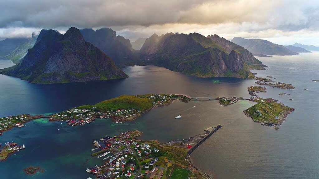
Picture this: jagged mountain peaks rising straight from turquoise waters, red fishing cabins perched on stilts, and roads that twist through scenery so dramatic you’ll forget to blink. That’s Lofoten—a chain of islands inside the Arctic Circle that looks like it was sketched by someone who’d never heard the word “subtle.” Getting to this Norwegian wonderland isn’t exactly like hopping on a subway. But here’s the good news: how to get to Lofoten Islands is way more straightforward than you’d think for such a remote destination. Whether you’re flying from New York, Mumbai, or Tokyo, this guide breaks down every ferry, flight, and mountain pass between you and one of Europe’s most jaw-dropping adventures. We’ll cover everything: the best routes from major cities, whether to fly or ferry from Bodø to Lofoten, how to snag a rental car Lofoten style, what a Lofoten itinerary 7 days looks like, and honest cost breakdowns. Plus, we’ve got insider tricks that’ll save you money and help you avoid the rookie mistakes that leave travelers stranded at a ferry terminal. Let’s get you to the Arctic. Why Lofoten Deserves the Journey First, let’s talk about why you’re even considering this trip. Lofoten archipelago travel isn’t for people who want easy beach resorts. This is for adventurers who get excited about standing on a mountain trail at midnight while the sun refuses to set. It’s for photographers who want to capture the Northern Lights Lofoten dancing above a fishing village Reine that looks straight out of a fairytale. The islands sit 200 kilometers north of the Arctic Circle, connected by bridges and tunnels that make the whole chain feel like one continuous adventure. The weather? Unpredictable. One minute you’re hiking Lofoten hiking trails in sunshine, the next you’re dodging horizontal rain. But that wild weather creates the dramatic light that makes every photo look like a National Geographic cover. From beaches in Lofoten like Kvalvika and Haukland (yes, Caribbean-colored water in the Arctic—seriously) to the vertical granite walls of fjords in Lofoten like Trollfjord, this place packs more scenery per square mile than anywhere else in Scandinavia. The remoteness is real, but it’s achievable. Thousands of travelers make it here every year, and with this guide, you will too. First Step: Getting to Norway (From Outside Europe) Major Gateway Cities Your Lofoten Islands Norway access journey starts with getting to Norway. For most international travelers, that means flying into one of these hubs: For travelers from Asia: A typical route from Mumbai or Delhi would be Mumbai → Oslo (via Dubai, Doha, or a European hub like Amsterdam) → Bodø → Lofoten. Flight time is roughly 12-16 hours total, not counting layovers. For American travelers: Direct flights from New York, Chicago, or Los Angeles to Oslo are your best bet. Norwegian Air and SAS offer competitive rates. From the U.S., you’re looking at 8-10 hours to Oslo. Visa & Practical Basics Norway is part of the Schengen Area. Most travelers need a Schengen visa (applied for through Norwegian embassies), which allows 90 days of travel within the zone. Americans, Canadians, Australians, and many Asian passport holders can check specific requirements at Norway’s official immigration site. Currency: Norwegian Krone (NOK). Credit cards are accepted everywhere, but it helps to have a small amount of cash for remote spots. Pro tip: Book a multi-city ticket. For example: fly into Oslo, spend a day exploring, then continue north. Or fly into Oslo and out of Tromsø to create a Northern Norway road trip loop. Primary Access Point: Oslo → Bodø Here’s where your journey gets real: Bodø is the jumping-off point for Lofoten. This coastal city sits right on the mainland across from the islands, and it’s the hub for ferries and regional flights heading to the archipelago. Getting to Bodø From Oslo, you have two main options: Booking tip: Norwegian domestic flights can get expensive if booked last-minute. Book 2-3 months ahead for the best prices. SAS often has sales during shoulder seasons (May, September). The Loop Strategy Here’s an insider move: Don’t book a round-trip to Bodø. Instead, fly into Bodø but fly out from Narvik/Harstad Airport (EVE) on the northern end of Lofoten. This creates a one-way route through the islands without backtracking. It adds maybe $30-50 to your ticket cost but saves a full day of travel time. How to Get from Bodø to Lofoten Islands This is the crucial leg. You’ve got three main options, and your choice depends on budget, time, and whether you want a car. Quick Comparison Table Method Time Cost (USD) Experience Best For Ferry (Car) 3-4 hours $100-150 (with car) Scenic, dolphins, mountains Road trippers, photographers Ferry (Walk-on) 3-4 hours $25-40 Budget-friendly, relaxing Public transport users Flight to Leknes/Svolvær 25-35 min $100-180 Fastest, aerial views Time-crunched travelers Drive via E10 5-6 hours Gas only (~$40) Ultimate scenic route Loop itinerary travelers Option 1: Ferry from Bodø to Moskenes The Bodø to Lofoten ferry is run by Torghatten Nord and sails to Moskenes on the southern tip of Lofoten. Details: Why take the ferry? On a clear day, you’ll sail past dramatic coastal mountains, potentially spot wildlife (we saw orcas on our September crossing), and arrive at Moskenes ready to explore the southern villages like Å and Reine. The ferry also serves as your “scenic introduction” to Lofoten. Pack snacks, grab a window seat, and keep your camera ready. Option 2: Fly to Leknes or Svolvær If time matters more than budget, fly. Widerøe operates short regional flights from Bodø. These tiny prop planes hold 30-40 people, and the views during takeoff are insane—you’re essentially flying at eye level with the mountains. Cost: $100-180 one-wayPro: Saves 3+ hours compared to the ferryCon: More expensive, and you’ll miss the ocean journey Option 3: Drive the E10 Highway For those coming from the north or doing a larger Norway loop, you can drive onto Lofoten via the E10 highway. The road connects through bridges and tunnels from the mainland. From