Africa Travel

Explore Africa travel guides, itineraries, safari experiences, places to visit, travel tips, and destination insights for popular destinations across East, West, North, and Southern Africa.

Namibia Tour Guide 2026: Best Safari, Road Trip Itinerary, Travel Tips & Hidden Gems

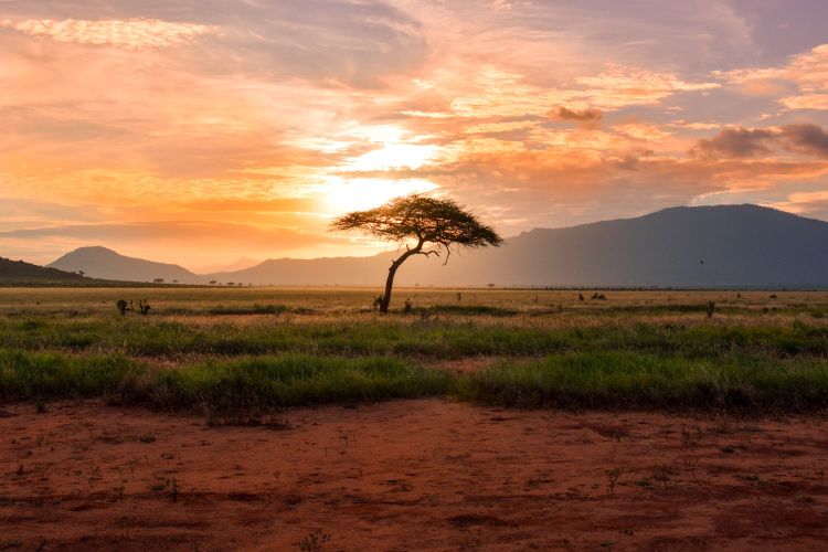
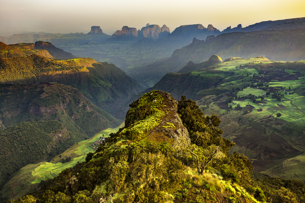
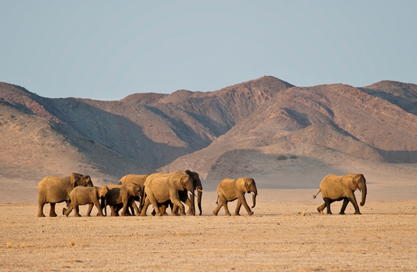
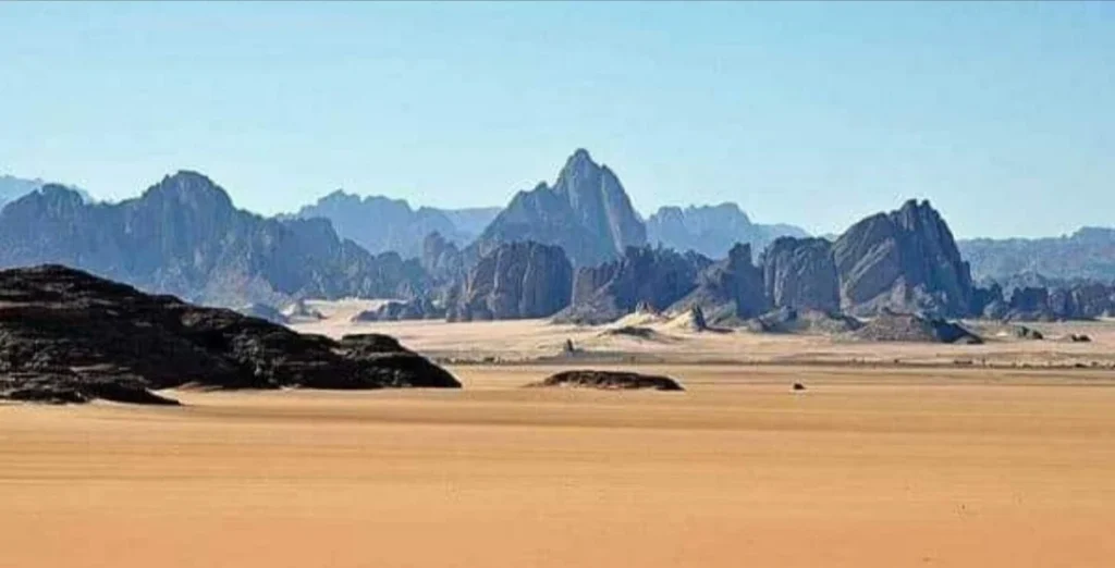
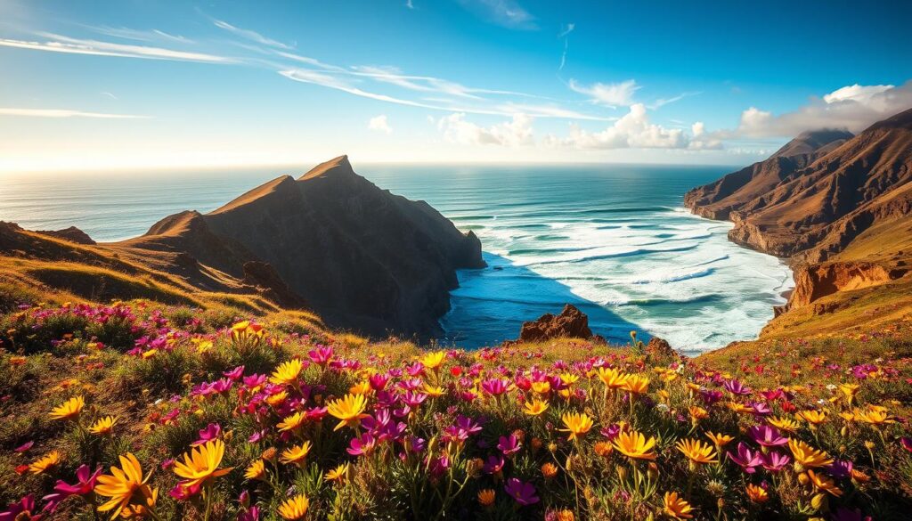
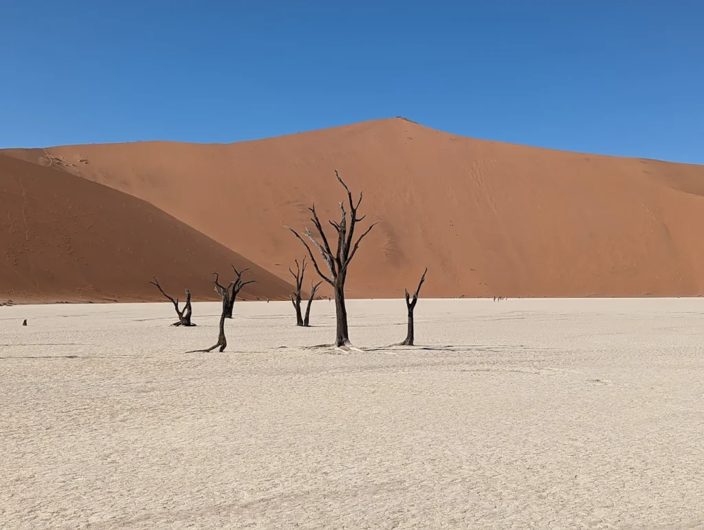
By Wahid Ali | Operations Lead & Travel Professional, Astamb Holidays | Mumbai Published on XploreHeaven.com | Updated: May 2026 Running holiday operations out of Mumbai, I spend a good part of my day helping travelers choose destinations that will genuinely stay with them. Most clients start by asking about Kenya or Tanzania — the familiar names, the ones they’ve seen on travel shows. But the clients who trust me enough to try a Namibia tour? They come back different. Quieter. Like they’ve seen something the rest of the world hasn’t quite caught up to yet. And honestly — they have. Namibia is vast, unhurried, and strikingly beautiful in a way that’s hard to prepare for. No traffic jams on safari roads. No crowds at a sunrise dune. Just wide-open desert, ancient landscapes, and wildlife living entirely on their own terms. In 2026, Namibia is finally getting the global attention it has always deserved. If you’ve been thinking about this trip, this guide will help you plan it right — with honest logistics, cultural context, and the kind of ground-level detail that only comes from years of crafting itineraries for destinations like this one. Why Is a Namibia Tour So Popular in 2026? Quick Answer: A Namibia tour is popular in 2026 because it offers self-drive freedom, world-class wildlife, extraordinary photography opportunities, and some of the darkest skies on Earth — all with far fewer tourists than East Africa. It’s the go-to destination for adventure travelers who want a genuine, uncrowded African experience. The numbers tell the story. Namibia recorded 863,872 tourist arrivals in 2023, an 87.4% increase from 2022 — a clear signal that the world is discovering what serious travelers have known for years. That momentum hasn’t stopped. Here’s what’s driving the surge in 2026: Africa’s safari tourism market generated USD 18 billion in 2023, with forecasts predicting it will nearly double to USD 34.5 billion by 2033, growing at a solid CAGR of 6.7%. Namibia is one of the biggest beneficiaries of this shift. What Are the Best Places To Visit on a Namibia Tour? Quick Answer: The must-visit stops on a Namibia tour are Sossusvlei, Deadvlei, Etosha National Park, Swakopmund, Skeleton Coast, Fish River Canyon, and Damaraland. Each offers something completely different — from red dunes and salt pans to desert wildlife and coastal fog. 1. Sossusvlei & Deadvlei This is the icon. The image most people associate with Namibia — those towering red-orange dunes against a white clay pan and black, dead camel thorn trees. 2. Etosha National Park Namibia’s wildlife crown jewel. Etosha is centered around a massive salt pan — during dry season, animals gather at waterholes in extraordinary numbers. 3. Swakopmund A quirky coastal town that feels like a German village dropped into a desert. It’s the adventure hub of Namibia — sandboarding, quad biking, kayaking with seals, and the best seafood in the country. 4. Skeleton Coast One of the most remote and culturally haunting stretches of coastline I’ve ever built an itinerary around. Shipwrecks, whale bones, massive Cape fur seal colonies, and desert-adapted lions. This isn’t a polished tourist attraction — it’s a raw, almost otherworldly edge of the continent. 5. Fish River Canyon The second-largest canyon in the world after the Grand Canyon, and criminally undervisited. 6. Damaraland This is where you find desert-adapted elephants and ancient rock engravings at Twyfelfontein (a UNESCO World Heritage Site). The landscapes are Mars-like. Completely surreal. 7. Spitzkoppe Often called the “Matterhorn of Namibia.” A granite inselberg rising out of the flat desert. Incredible for bouldering, rock art, and camping under a sky so full of stars you’ll feel dizzy. What Is the Best Namibia Tour Itinerary? Quick Answer: The ideal Namibia tour itinerary is 10 to 14 days. A 7-day trip is possible but rushed. A 14-day itinerary lets you cover the south (Sossusvlei), coast (Swakopmund/Skeleton Coast), and north (Etosha) without the stress of long daily drives. 7-Day Namibia Tour Itinerary (Fast-Paced — Best for Time-Limited Travelers) Day Route Driving Time Day 1 Arrive Windhoek → Drive to Sesriem ~5 hours Day 2 Sossusvlei & Deadvlei (sunrise) → Sesriem night — Day 3 Sesriem → Swakopmund via Solitaire ~4.5 hours Day 4 Swakopmund activities (sandboarding, seals) — Day 5 Swakopmund → Etosha South Gate ~5 hours Day 6 Full day Etosha game drive — Day 7 Etosha → Windhoek (fly home) ~5 hours 10-Day Namibia Tour Itinerary (The Sweet Spot) Day Route Highlights Day 1 Arrive Windhoek, stock provisions Rest, groceries Day 2 Windhoek → Sesriem Solitaire detour Day 3 Sossusvlei & Deadvlei (sunrise + sunset) Two photo sessions Day 4 Sesriem → Swakopmund Welwitschia Drive stop Day 5 Swakopmund Adventures + Walvis Bay Day 6 Swakopmund → Spitzkoppe Sunset at the rocks Day 7 Spitzkoppe → Damaraland/Twyfelfontein Rock art + elephant tracking Day 8 Damaraland → Etosha (south) Afternoon game drive Day 9 Full day Etosha Waterhole night session Day 10 Etosha → Windhoek Depart 14-Day Namibia Tour Itinerary (The Full Circuit) Add Fish River Canyon (Days 1–3), then work north through Lüderitz, Sossusvlei, Swakopmund, Skeleton Coast, Damaraland, and Etosha. This is the itinerary I personally recommend for first-timers who want to do it properly. Realistic driving note: Gravel roads in Namibia average 60–80 km/h max. Tarmac is rare outside main routes. Always add 30% more time than Google Maps tells you. Is a Self-Drive Namibia Tour Worth It? Quick Answer: Yes — absolutely. A self-drive Namibia tour saves you $100–$200 per person per day versus a guided tour. The roads are well-signed, the distances are manageable with planning, and the freedom you get is worth every kilometer. Here’s the honest breakdown: 4×4 vs SUV — What Do You Actually Need? Vehicle Type Best For Roads Covered Cost (per day) Standard 4×4 (e.g., Toyota Hilux) Full Namibia circuit All roads including sand ~$100–$150 USD High-clearance SUV Main routes only Tarmac + good gravel ~$80–$120 USD Budget sedan Windhoek only Tarmac only ~$40–$60 USD My honest advice? Get the 4×4. Sossusvlei’s

Namibia Tour Guide 2026: Best Safari, Road Trip Itinerary, Travel Tips & Hidden Gems Read More »

What Is the Quirimbas Archipelago Mozambique Known For? Complete Travel & Nature Guide

Introduction to the Quirimbas Archipelago Mozambique 🌊 Imagine stepping onto powdery white sand where your footprints are the only ones for miles. Picture crystal-clear turquoise waters hiding vibrant coral gardens teeming with sea turtles and rare dugongs. Welcome to the Quirimbas Archipelago Mozambique—one of Africa’s best-kept secrets and a paradise that most travelers haven’t even heard of yet. Stretching along 250 kilometers of Northern Mozambique’s coastline in the Cabo Delgado province, the Quirimbas Archipelago consists of 32 stunning coral islands that rise from the warm Indian Ocean. These aren’t your typical tourist-packed tropical islands. The Mozambique Indian Ocean coral islands remain blissfully undiscovered, offering an authentic escape where nature reigns supreme and ancient cultures thrive undisturbed. What makes this archipelago truly extraordinary? It’s the perfect blend of untouched natural beauty, incredible marine biodiversity, and rich Swahili-Portuguese history that you won’t find anywhere else. From the crumbling colonial forts of Ibo Island to the exclusive diving havens of Vamizi and Medjumbe, each island tells its own captivating story. Unlike the Maldives or Seychelles, the Quirimbas remain refreshingly uncommercialized. Here, you can witness endangered sea turtles nesting on moonlit beaches, spot the elusive dugong grazing in shallow seagrass beds, and explore coral reefs so pristine they seem painted by nature’s finest artist. The archipelago is protected as part of the Quirimbas National Park, ensuring these wonders remain preserved for generations to come. Whether you’re a marine life enthusiast, history buff, luxury traveler, or adventurer seeking the road less traveled, the Quirimbas Archipelago Mozambique delivers experiences that money often can’t buy elsewhere—genuine connection with nature and culture in their purest forms. Quick Reference Guide: Quirimbas Archipelago Mozambique Essential Information Details Location Northern Mozambique, Cabo Delgado Province, Indian Ocean Number of Islands 32 coral islands stretching 250km Best Time to Visit May to November (dry season) Main Gateway Pemba (connecting flights from Maputo) Key Islands Ibo, Vamizi, Medjumbe, Matemo, Quirimba Protected Status Quirimbas National Park, UNESCO Tentative List Famous For Pristine coral reefs, 5 turtle species, dugongs, Swahili-Portuguese history Activities Diving, snorkeling, dhow cruises, cultural tours, wildlife watching Travel Style Eco-luxury resorts to rustic island stays Language Portuguese (official), Makua, Swahili, English at resorts Currency Mozambican Metical (MZN) The Natural Wonders: Biodiversity & Marine Life 🐢 The Quirimbas Archipelago isn’t just beautiful—it’s a living laboratory of biodiversity that rivals anywhere on Earth. The moment you dip below the surface, you’ll understand why marine biologists get so excited about this place. Coral Reefs: Underwater Rainforests The coral reefs surrounding these islands are nothing short of spectacular. Stretching for miles, these underwater ecosystems showcase over 375 species of fish and nearly 50 types of coral. The water clarity here is exceptional—visibility often exceeds 30 meters, making it a photographer’s dream and a diver’s paradise. What sets these reefs apart is their pristine health. Unlike many global reef systems suffering from bleaching and pollution, the Quirimbas reefs remain vibrant thanks to minimal human impact and strong conservation efforts. The Quirimbas National Park biodiversity protection measures have created natural sanctuaries where marine life flourishes without disruption [SOURCE LINK: UNESCO]. The Magnificent Five: Sea Turtle Species Here’s where the Quirimbas truly shines—this archipelago hosts all five species of sea turtles found in the Indian Ocean: 🐢 Loggerhead Turtles – The most commonly spotted, these gentle giants nest on remote beaches from November to March. Their reddish-brown shells and massive heads make them easy to identify. 🐢 Green Turtles – Named for the greenish color of their fat (not their shells), these herbivores graze on seagrass beds in shallow lagoons. You’ll often see them surfacing for air during snorkeling trips. 🐢 Hawksbill Turtles – With their distinctive bird-like beaks and beautifully patterned shells, hawksbills are the reef specialists, feeding on sponges tucked into coral crevices. 🐢 Leatherback Turtles – The ocean giants! These massive creatures can weigh over 900 kilograms and dive to incredible depths. Spotting one is a once-in-a-lifetime moment. 🐢 Olive Ridley Turtles – The smallest and most abundant sea turtle species globally, though less common here than their cousins. Images Source: https://www.mozambiquetravel.com/blog/turtle-conservation-in-mozambique/ The beaches of Vamizi Island and several uninhabited islands serve as critical nesting sites, monitored by conservation teams who protect eggs from poachers and predators [SOURCE LINK: Marine Megafauna Foundation]. The Shy Dugong: Ocean’s Gentle Gardener Perhaps the most special resident of the Quirimbas is the dugong—a marine mammal so rare that many divers never see one in their lifetime. These gentle “sea cows” graze on seagrass meadows in shallow protected bays, particularly around Vamizi and the southern islands. Dugongs are critically endangered throughout their range, but the Quirimbas harbors one of the healthier populations along Africa’s east coast. Estimated numbers suggest around 200 individuals use these waters, though spotting them requires patience and luck [SOURCE LINK: Save Our Seas Foundation]. They’re shy creatures, usually feeding in early morning or late afternoon when boat traffic is minimal. Seasonal Marine Visitors Between June and November, the archipelago welcomes magnificent humpback whales migrating from Antarctic feeding grounds to warmer breeding waters. Watching a 40-ton whale breach against the backdrop of tropical islands is pure magic. Dolphins are year-round residents, with spinner, bottlenose, and humpback dolphins frequently bow-riding alongside dhows and boats. Their playful nature adds joy to every boat journey. Beyond the Water: Island Wildlife While the marine life steals the spotlight, the terrestrial ecosystems shouldn’t be overlooked. The islands and adjacent mainland support: Source: https://www.mozambique.co.za/Mozambique_Wildlife-travel/mozambique-birding-hotspots.html The mangrove forests deserve special mention—these twisted, salt-tolerant trees create nurseries for countless fish species while protecting coastlines from erosion and storms. The Quirimbas contains some of East Africa’s most extensive and healthy mangrove systems [SOURCE LINK: WWF]. Quirimbas National Park: Conservation & Protected Status 🌿 Created in 2002, Quirimbas National Park represents one of Africa’s most ambitious conservation projects, protecting an astounding 7,500 square kilometers of marine and terrestrial ecosystems. This includes 11 of the 32 islands plus a significant chunk of coastal mainland in Cabo Delgado province. A Model of Community-Led Conservation What makes this park truly revolutionary

What Is the Quirimbas Archipelago Mozambique Known For? Complete Travel & Nature Guide Read More »

Is Angola Safe to Travel in 2025? Your Essential Guide to Health, Crime, and Landmine Safety

Is Angola safe to travel? Yes, but travel here requires mandatory preparation and constant situational awareness. International authorities generally classify Angola under a Level 2: Exercise Increased Caution or Exercise a High Degree of Caution. This level of risk is driven by violent crime, especially in the capital, Luanda, and critical deficiencies in medical facilities outside of large cities. While provincial cities like Benguela and Lubango are often described as calm and orderly for visitors, your safety relies entirely on robust planning around specific threats: the pervasive risk of landmines and unexploded ordnance (UXO) outside main, paved roads, and the non-negotiable need for medical evacuation (Medevac) insurance, as serious medical emergencies typically require treatment outside the country. Do not attempt this trip without mastering the crucial security and health protocols detailed below—they are the difference between an unforgettable adventure and an unmanageable crisis. Angola is a country bursting with potential, featuring beautiful landscapes from the Serra da Leba pass to the revitalization of Kissama National Park. For many adventurous travellers, this Southern African nation offers an unforgettable experience. However, travel here comes with a specific set of challenges that require detailed preparation, turning this trip into an operation of careful planning. Is Angola safe to travel? The answer is yes, provided you adhere strictly to official safety and health protocols, treating preparedness as mandatory. This guide breaks down the realistic risks of travel, focusing on safety, health, and logistics, so you can focus on enjoying Angola with confidence and peace of mind. Official Travel Risk: Why Angola is ‘Exercise Increased Caution’ Major international governments, including the United States, Canada, and New Zealand, consistently advise travellers to Exercise Increased Caution in Angola. Canada further escalates this advice to Exercise a High Degree of Caution. This moderate risk level is based on three persistent threats: high levels of violent crime, particularly in the capital; a widespread legacy of landmines and unexploded ordnance (UXO); and critical deficiencies in the local health and emergency response systems. Unique Value: Decoding the Mandates • Contingency Planning is Essential: Before you leave, you must prepare a comprehensive contingency plan for emergency situations. This involves knowing your medical evacuation route and having enough money to cover unexpected costs. • Mandatory Registration: U.S. citizens should enrol in the Smart Traveler Enrollment Program (STEP) to receive security alerts and make it easier for authorities to locate you in an emergency. • Consular Limitations: If you are travelling to remote or high-risk areas, remember that consular assistance from governments like New Zealand or Canada may be severely limited or non-existent. Is Angola Safe to Travel in Luanda? Navigating Urban Crime and ‘Smash and Grab’ Risks Luanda, the capital, is the primary source of the national “Increased Caution” rating. It experiences a high level of crime, some of it violent, including armed robbery, assault, carjacking, and homicide. Local police often lack the resources to respond effectively to serious criminal incidents. Unique Value: Specific Security Protocols • The Non-Resistance Protocol: If you are threatened by armed individuals, the most crucial security protocol is to immediately hand over your cash and valuables. Resistance has often proven fatal. • The “Smash and Grab” Threat: A common criminal tactic involves individuals, often riding motorcycles, targeting electronics like mobile phones and laptops from cars that are stopped or slow in traffic. You must keep valuables out of sight and refrain from using your mobile phone or laptop when stopped. • Vetted Transport is Key: Avoid walking alone, particularly after dark. Public transport, such as multi-passenger vans (candongueiros) or motorcycles (taxistas), is generally unregulated and unsafe. The safest practice is to use private transport from reliable sources or vetted ride services like UGO. • Women and LGBTQ+ Travelers: Incidents of rape and sexual assault have been reported in popular nightlife areas. While Angola has decriminalised same-sex relationships, societal biases against LGBTQ+ individuals exist, and public displays of affection may attract negative attention. The Landmine and UXO Reality: Is Angola Safe Outside Major Cities? The most pervasive physical safety risk outside Luanda and the provincial capitals is the presence of landmines and unexploded ordnance (UXO), a devastating legacy of four decades of conflict. Angola remains one of the most heavily mined countries in the world, with over 61 million square meters of land contaminated. Unique Value: The Mandatory Landmine Protocol • Strict Adherence to Cleared Routes: The risk of encountering UXO is especially high on unpaved roads, verges, and near bridges. You must never deviate from main, paved, and heavily frequented roads. Even areas previously thought to be clear may contain mines. • Rainy Season Threat: The rainy season (typically November to April) increases the chance of landmines shifting due to flooding and reappearing on roadways outside known minefields. • Economic Impact and Clearance: International organizations like MAG and The HALO Trust are actively engaged in humanitarian demining, clearing land to allow for safe development in provinces like Moxico and Huambo. Clearance efforts are also crucial for strategic infrastructure projects like the Lobito Corridor. Critical Health Safety: Is Angola Safe Without Medical Evacuation (Medevac) Insurance? The quality of healthcare in Angola is a critical factor in personal safety. Medical facilities are under-resourced and often do not meet international standards, especially outside of Luanda. Unique Value: Medevac and Cash Reserves • Medevac is Mandatory: You must purchase comprehensive travel insurance that explicitly covers medical evacuation (Medevac). For serious or complex care, treatment in the country is usually inadequate, necessitating medical flight to a third country like South Africa. • The Cash-Only Rule: Hospitals and doctors, even at the competent private clinics in Luanda, typically require cash payment upfront prior to providing service or admission. Be prepared to pay high fees. • Bypassing Local Emergency Services: Local ambulance services (dial 111 or 112/116) are generally unreliable and poorly equipped outside the capital. Seriously injured or ill travellers are sometimes advised to take a secured private vehicle or vetted UGO taxi directly to the nearest major hospital instead of waiting. •

Is Angola Safe to Travel in 2025? Your Essential Guide to Health, Crime, and Landmine Safety Read More »

What Animals Live in Bale Mountains Ethiopia? Complete Wildlife Guide

Standing at dawn on the windswept Sanetti Plateau, you might spot something extraordinary—a rust-colored wolf silhouetted against Africa’s largest Afro-alpine moorland. This isn’t just any wildlife encounter. The Bale Mountains Ethiopia harbor one of Earth’s most remarkable concentrations of endemic species, creatures found absolutely nowhere else on the planet. Stretching across southeastern Ethiopia, this UNESCO World Heritage Site candidate rises from 1,500 meters in the misty Harenna Forest to over 4,000 meters on the frozen plateau, creating a “lost world” where evolution took a unique path. The Bale Mountains aren’t just mountains—they’re living laboratories where rare Ethiopian Wolves hunt Giant Molerats, Mountain Nyalas browse ancient woodlands, and Bale Monkeys swing through bamboo forests that time forgot. Quick Reference: Bale Mountains Wildlife at a Glance 🗺️ Category Key Information Location Southeastern Ethiopia, Oromia Region Altitude Range 1,500m – 4,377m (Tullu Dimtu peak) Main Habitats Afro-alpine Plateau, Montane Woodlands, Harenna Forest Flagship Species Ethiopian Wolf, Mountain Nyala, Bale Monkey Total Mammal Species 78+ species (29 endemic to Ethiopia) Bird Species 300+ species (16 endemic) Best Wildlife Months October – January (dry season) UNESCO Status World Heritage Site Tentative List Conservation Priority Critical (home to world’s rarest canid) Unique Feature Highest endemism rate for any mountain ecosystem globally Flagship Species — The Icons of Bale 🐺 Ethiopian Wolf (Canis simensis) Imagine a fox that evolved into a wolf—that’s essentially what you’re looking at when you spot an Ethiopian Wolf. With its long legs built for the high-altitude chase, russet-red coat blazing against dark moorland, and distinctive white throat markings, this creature looks like it wandered out of a wildlife photographer’s dream. But here’s what makes your heart skip: fewer than 500 individuals exist on Earth, making this the world’s most endangered canid species. You’ll find them on the Sanetti Plateau, usually at dawn or dusk, nose-down in a hunting crouch. What are they hunting? Giant Molerats—those bizarre, buck-toothed rodents that pop up from underground burrows like whack-a-mole targets. The Ethiopian Wolf has perfected a hunting technique over millennia: patient stalking followed by a lightning-fast pounce. This predator-prey relationship isn’t just fascinating—it’s the backbone of the entire Afro-alpine ecosystem [Source: Ethiopian Wolf Conservation Programme]. Your best chance of spotting one? Drive the road crossing Sanetti Plateau between 6-8 AM. They’re surprisingly tolerant of vehicles when you maintain respectful distance, often hunting within 50 meters of the road. During mating season (August-November), you might even witness pack dynamics, with subordinate wolves helping raise pups in a communal den [Source: IUCN Red List – Ethiopian Wolf]. Mountain Nyala (Tragelaphus buxtoni) Picture an antelope the size of a large horse, draped in shaggy chocolate-brown fur, with males sporting magnificent spiral horns that corkscrew up to 118 centimeters. The Mountain Nyala is Ethiopia’s answer to the kudu, but bigger, rarer, and infinitely more elusive. These gentle giants are endemic to Ethiopia’s highlands, with the Bale Mountains hosting the largest population. Mountain Nyalas prefer the transition zones—where montane woodlands meet forest edges, particularly around 3,000-3,400 meters elevation. They’re browsers, not grazers, delicately selecting leaves, shoots, and lichens with lips as precise as surgical instruments. Males are solitary wanderers for most of the year, only joining female herds during the November-December breeding season. Females travel in small groups of 4-6 individuals, often with calves hiding in thick vegetation. Spotting them requires patience and local knowledge. The Dinsho area, near park headquarters, offers your best odds, especially early morning when they venture into open glades to feed. Move slowly, speak softly, and you’ll witness behaviors that few outsiders ever see—the territorial displays of dominant males, the protective vigilance of mothers, the playful curiosity of young calves [Source: African Wildlife Foundation – Mountain Nyala]. Lesser-Known Mammals — Rodents, Primates & More 🐒 Bale Monkey (Chlorocebus djamdjamensis) Here’s something most visitors miss entirely: deep in the Harenna Forest, a unique primate species swings through bamboo canopies in troops of 20-30 individuals. The Bale Monkey, also called the Bale Mountains Vervet, isn’t just another monkey—it’s a bamboo specialist found nowhere else. Unlike their lowland cousins, Bale Monkeys have adapted to life at 2,400-3,400 meters, where temperatures drop to freezing at night. Their diet consists heavily of bamboo shoots, leaves, and seeds, supplemented by forest fruits when available. Watch them closely and you’ll notice their thick fur coats, smaller body size compared to lowland vervets, and distinctive social behaviors adapted to dense forest living. The Harenna Forest’s southern slopes provide the best viewing opportunities. Trek the Katcha Trail or the route toward Rira, and listen for their sharp alarm calls echoing through the canopy. They’re most active mid-morning when sunlight penetrates the forest, warming their preferred feeding zones. What makes them truly special? They represent an evolutionary adaptation to high-altitude forest life that scientists are still studying [Source: Primate Conservation – Bale Monkey Research]. Giant Molerat (Tachyoryctes macrocephalus) You might think a rat deserves less attention than wolves and antelopes. You’d be wrong. The Giant Molerat is the unsung hero of the Bale Mountains Ethiopia ecosystem, and here’s why: without them, the Ethiopian Wolves wouldn’t survive. These bizarre creatures look like someone mixed a beaver’s teeth with a potato, added tiny eyes (they’re nearly blind), and created an underground earth-moving machine. Weighing up to 900 grams, they’re the largest molerats in Africa. They spend 99% of their lives underground, excavating elaborate tunnel systems up to 3 meters deep, pushing up fresh soil mounds that dot the plateau like miniature volcanoes. Here’s where it gets fascinating: Giant Molerats are the primary food source for Ethiopian Wolves, comprising up to 96% of their diet on the Sanetti Plateau. But their importance goes beyond being prey. Their constant digging aerates the soil, prevents vegetation from becoming too woody, and essentially maintains the entire Afro-alpine heathland ecosystem. They’re ecosystem engineers in the truest sense [Source: Journal of Zoology – Molerat Ecology Studies]. You won’t see them easily—they’re underground. But you’ll see their fresh earth mounds everywhere on the plateau, and if you’re incredibly patient and lucky, you might

What Animals Live in Bale Mountains Ethiopia? Complete Wildlife Guide Read More »

What to Do in Damaraland — Complete Travel Guide for First-Timers

Picture this: you’re standing in a landscape that feels like Mars decided to host an African wildlife show. The ground beneath your feet is 260 million years old, ancient rock art covers canyon walls, and somewhere in the distance, a family of elephants navigates the desert like they own the place (spoiler: they do). Welcome to Damaraland, where nature wrote its most dramatic script and forgot to add any other tourists to the scene. If you’re wondering what to do in Damaraland, you’ve landed in the right corner of the internet. This isn’t your standard safari destination with paved roads and gift shops. Damaraland is raw, remote, and ridiculously beautiful—a place where geological wonders meet prehistoric art and wildlife that shouldn’t survive here somehow thrives. Located in Namibia’s rugged Kunene Region, Damaraland stretches across roughly 42,000 square kilometers of rock formations, dry riverbeds, and stark desert beauty. This isn’t a place you’ll stumble upon by accident. It takes effort to reach, but that’s exactly what keeps it special. You won’t find safari traffic jams here—just you, the landscape, and animals that adapted to survive where others couldn’t. This guide breaks down everything you need to know: the ancient rock engravings that’ll make you rethink human history, the wildlife that defies desert logic, the geological formations that look computer-generated but are entirely natural, and the practical stuff like when to visit and whether you actually need that 4×4 everyone keeps talking about. Quick Reference: Damaraland Travel Essentials Essential Info Details Location Kunene Region, northwestern Namibia Best Time to Visit May to October (dry season) Must-See Attractions Twyfelfontein rock art, desert elephants, Brandberg Mountain Wildlife Highlights Desert-adapted elephants, black rhino, oryx, mountain zebra Recommended Duration 3-4 days for full experience Getting There Self-drive from Windhoek (5-6 hours) or fly to Palmwag Vehicle Needed 4×4 recommended for most areas Accommodation Types Eco-lodges, tented camps, camping sites Average Daily Budget $80-250 USD (mid-range) Terrain Type Rocky desert, gravel roads, mountain passes Best Time to Visit & How to Reach Damaraland Timing can make or break your Damaraland adventure, and getting there requires a bit more planning than booking a flight to a beach resort. When Should You Go? The best time to visit Damaraland runs from May through October during Namibia’s dry season. Here’s why these months work so well: Dry Season (May-October): Temperatures hover between 20-25°C (68-77°F) during the day, dropping to 5-10°C (41-50°F) at night. Wildlife congregates around permanent water sources, making animal spotting significantly easier. The roads are in better condition, and you won’t need to worry about flash floods blocking your route. According to the Namibia Tourism Board, this period sees the clearest skies for stargazing—a legitimate highlight in this low-light-pollution zone. Green Season (November-April): Summer brings occasional rains, temperatures climbing to 35°C (95°F), and vegetation that transforms the landscape into something greener but less Mars-like. Wildlife disperses as water becomes available everywhere. Roads can become challenging, sometimes impassable. However, if you’re a photographer chasing dramatic storm clouds over red rocks, this season delivers. January through March is particularly hot and humid. Unless you enjoy feeling like you’re hiking inside a hair dryer, save these months for somewhere with air conditioning. Getting to Damaraland By Air: Fly into Windhoek’s Hosea Kutako International Airport. From there, you can take a chartered flight to smaller airstrips near Palmwag or Damaraland Camp (if your accommodation arranges it), or drive. Some visitors fly into Walvis Bay and drive north. By Road: Most people self-drive from Windhoek, which takes 5-6 hours covering roughly 350-400 kilometers depending on your exact destination. The C39 and C43 gravel roads are your main arteries through the region. These aren’t highways—expect washboard surfaces, occasional sharp rocks, and the need to drop your speed significantly. Vehicle Requirements: Here’s the honest answer about the 4×4 question: you can reach some main attractions like Twyfelfontein with a high-clearance 2WD sedan, but a 4×4 opens up significantly more territory. For wildlife tracking, visiting the Petrified Forest, or accessing remote camps, you’ll want four-wheel drive. Rental costs in Namibia run $50-120 USD daily for 4x4s depending on the season and vehicle type. Guided Tours vs Self-Drive: Self-driving gives you freedom and flexibility. Guided tours provide expert wildlife tracking and cultural context you’d otherwise miss. Companies like Wilderness Safaris and Natural Selection operate excellent guided experiences through the region. Budget $300-500 USD per person daily for full-service guided tours. 🎨 Top Must-See Attractions: Rock Art & Geological Wonders Damaraland’s attractions read like someone challenged nature to show off. Between UNESCO World Heritage rock art and geological formations that science teachers use as textbook examples, you’ll need more memory cards than you packed. Twyfelfontein Rock Engravings Twyfelfontein holds Africa’s largest concentration of rock petroglyphs and paintings, with over 2,500 individual works created by San hunter-gatherers roughly 6,000 years ago. UNESCO declared it a World Heritage Site in 2007, and standing among these ancient artworks feels like reading humanity’s first travel blog. The engravings cover hunting scenes, animal tracks, and geometric patterns etched into sandstone slabs. You’ll spot giraffes, elephants, ostriches, and the famous “swimming lion”—though why ancient artists depicted a lion swimming in a desert remains delightfully mysterious. Visiting Tips: You must join a guided walk (required by law to protect the site). Tours cost approximately $10-15 USD per person and last 45-60 minutes. Mornings before 10 AM offer the best light for photography and cooler temperatures. The site has basic facilities but no restaurant, so bring water and snacks. Brandberg Mountain & The White Lady Painting Brandberg Massif rises 2,573 meters above sea level, making it Namibia’s highest peak. The granite mountain glows orange-red at sunrise—hence “Brandberg” (Fire Mountain). Hidden in a gorge on its slopes sits the famous White Lady rock painting, discovered in 1918 by German surveyor Reinhard Maack. Despite the name, the figure probably isn’t female or white—it’s likely a San shaman painted with white clay as part of a ceremonial scene. The painting dates back roughly 2,000 years and remains remarkably

What to Do in Damaraland — Complete Travel Guide for First-Timers Read More »

Facts About Zakouma National Park — Wildlife, History & Conservation Triumph in Chad

Picture this: endless golden savannas stretching to the horizon, massive elephant herds kicking up dust clouds, and the world’s rarest giraffes grazing peacefully under the African sun. This isn’t a scene from the past—it’s happening right now at Zakouma National Park in Chad, one of Africa’s most remarkable conservation comebacks. If you’re searching for facts about Zakouma National Park, you’ve landed in the right place. This Central African treasure has transformed from a wildlife crisis zone into a shining example of what dedicated conservation can achieve. Tucked away in southeastern Chad, Zakouma represents something increasingly rare: a genuinely wild African experience where nature still calls the shots. The park’s story reads like a Hollywood script—complete with a devastating tragedy, heroes who refused to give up, and a triumphant recovery that continues today. 🦒 Zakouma at a Glance Quick Facts Details Location Southeastern Chad, Salamat Region Size 3,000 square kilometers (1,158 square miles) Established 1963 Ecosystem Type Sudano-Sahelian savanna Main Water Source Bahr Salamat River Management African Parks (since 2010) Signature Species Kordofan giraffe, African bush elephant Best Time to Visit November to April (Dry Season) Peak Wildlife Viewing March-April Access Point N’Djamena (capital city) Accommodation Tinga Camp (luxury tented camp) 🌍 Where Nature Still Runs Wild: Understanding Zakouma’s Unique Ecosystem Zakouma National Park stands as the last intact Sudano-Sahelian savanna ecosystem on Earth. Let that sink in for a moment—the last one. When you visit Zakouma, you’re not just seeing another African park; you’re experiencing a landscape that exists nowhere else in this pristine form. The park sprawls across 3,000 square kilometers of southeastern Chad, where the Bahr Salamat River breathes life into an otherwise harsh environment. During the wet season, this river transforms the landscape into a patchwork of seasonal floodplains and marshes. Come the dry months, these same floodplains become vital gathering spots for wildlife—creating some of the most spectacular animal concentrations you’ll find anywhere in Africa. The landscape shifts between open grasslands, acacia woodlands, and those crucial seasonal wetlands. This variety creates perfect conditions for an incredible range of species. The park sits within the Greater Zakouma Ecosystem, which includes the Siniaka-Minia Faunal Reserve to the south, giving wildlife even more room to roam and thrive. What makes Zakouma’s ecosystem truly special is its authentic wildness. There are no paved roads, no sprawling lodges, no crowds of safari vehicles. Just you, the animals, and Africa the way it’s meant to be experienced. 🐘 The Wildlife Stars of Zakouma The Elephant Miracle Here’s where Zakouma’s story gets really powerful. Back in the 1970s, roughly 22,000 African bush elephants roamed these lands. Then came the dark years of poaching. By 2010, that number had crashed to a heartbreaking 454 individuals. The 2006 elephant slaughter remains one of the most tragic events in African conservation history, when armed poachers killed hundreds of elephants in brutal raids. But this story doesn’t end in tragedy—it transforms into triumph. Since African Parks took over management in 2010, Zakouma’s elephant population has made an incredible recovery. Today, herds number over 500, with calves being born every year. Even more impressive? The park has achieved nearly a decade of zero-poaching incidents. That’s not luck—that’s the result of dedicated anti-poaching teams, cutting-edge technology, and genuine community partnership. Watching Zakouma’s elephant herds today feels like witnessing a resurrection. These aren’t scattered, fearful groups hiding in the bush. We’re talking about confident, growing herds that move freely across the savanna, with young elephants playing and learning from their elders just as nature intended. The Last Giraffe Stronghold If the elephant story impresses you, wait until you hear about the Kordofan giraffe. Zakouma holds roughly 70% of the entire wild Kordofan giraffe population—making this park absolutely critical for the subspecies’ survival. Current estimates put the park’s giraffe population between 1,380 and 1,500 individuals. Outside Zakouma, these gentle giants are vanishing across their former range. This makes every giraffe birth in the park a victory not just for Zakouma, but for the entire subspecies. Watching these towering beauties move gracefully across the Sudano-Sahelian savanna ranks among Africa’s most moving wildlife experiences. Beyond the Mega-Mammals While elephants and giraffes steal the spotlight (and rightfully so), Zakouma hosts an impressive supporting cast: African buffalo gather in huge herds during the dry season, sometimes numbering in the thousands. African lions prowl the grasslands, their populations steadily growing as prey numbers increase. You’ll spot various antelope species, including roan antelope, topi, and hartebeest. Bird lovers, prepare to have your minds blown. Between November and April, massive flocks of Red-billed quelea descend on Zakouma—we’re talking millions of birds creating swirling, shape-shifting clouds in the sky. It’s a natural spectacle that rivals any mammal migration. 💪 From Crisis to Conservation Triumph: Zakouma’s Incredible Journey The Dark Days To truly appreciate Zakouma today, you need to understand where it’s been. The mid-2000s represented the park’s darkest hour. Heavily armed poaching gangs, often crossing from Sudan, targeted elephants for their ivory with military precision. The 2006 elephant slaughter saw coordinated attacks that killed hundreds of elephants in single raids. Rangers faced impossible odds—outgunned, under-resourced, and sometimes outnumbered. Wildlife populations crashed. The international community watched in horror as one of Africa’s great parks teetered on the edge of collapse. The Turning Point In 2010, the Chadian government made a bold decision: partner with African Parks, a nonprofit conservation organization known for turning around failing parks across Africa. This wasn’t just a management change—it was a complete transformation of how Zakouma operated. African Parks brought serious resources, professional training, and most importantly, a comprehensive approach that went far beyond just fighting poachers. They understood that lasting conservation success required winning hearts and minds, not just battles. Building the Success The anti-poaching strategy African Parks implemented combined multiple elements: Professional ranger training transformed park guards into a highly skilled force. Modern equipment—radios, vehicles, aircraft for aerial surveillance—gave rangers the tools they needed. Intelligence networks helped predict and prevent poaching attempts before they happened. But here’s what really made the difference:

Facts About Zakouma National Park — Wildlife, History & Conservation Triumph in Chad Read More »

The Best Time to Visit the Masai Mara: A Complete Guide for Indian Travelers

Picture this: You’re sitting in an open safari vehicle as the African sun paints the sky golden orange. Suddenly, thunder fills the air – not from clouds, but from thousands of hooves. A massive herd of wildebeest charges toward the crocodile-filled Mara River, their survival instincts driving them forward in one of nature’s most spectacular displays. This is the Masai Mara during migration season, and timing your visit right means the difference between witnessing this magic or missing it entirely. As safari planning experts who’ve helped hundreds of Indian travelers experience Africa’s wonders, we know that choosing when to visit the Masai Mara can make or break your dream safari. The good news? Every month offers something special in this incredible ecosystem. The key is matching your travel goals with the right season. Quick Planning Summary Your Goal Best Months Why See the Great Migration July – October Peak river crossings, dramatic wildlife action Save Money & Avoid Crowds April – May, November Green season beauty, 40-50% lower prices See Baby Animals January – March Calving season, incredible predator activity Best Weather June – October Dry season, clear skies, easy game drives Bird Watching November – April Migratory birds arrive, lush landscapes Masai Mara: The Basics for First-Time Visitors Located in Kenya’s Great Rift Valley, the Masai Mara welcomes 1.5 million wildebeest onto its sprawling savannahs each July through October during the world-famous Great Migration. This 1,510 square kilometer reserve connects seamlessly with Tanzania’s Serengeti, creating one of Africa’s most important wildlife ecosystems. Understanding the Mara’s two main seasons is crucial for planning: Dry Season (June – October): Clear skies, sparse vegetation makes wildlife easier to spot, but expect higher prices and more tourists. Green Season (November – May): Lush landscapes, fewer crowds, and budget-friendly rates, but afternoon rain showers are common. Month-by-Month Guide to the Masai Mara January – March: The Secret Calving Season Weather: Hot days (25-28°C), cool nights, occasional short showers Wildlife Highlights: Wildebeest calving season in southern Serengeti, newborn animals attract predators Pros: Cons: One thing you’ll notice right away in January is how active the predators become. Our guides always recommend early morning game drives during this period because big cats are most active when temperatures are cooler. April – May: The Hidden Gem Season Weather: Long rains begin, afternoon thunderstorms, lush green landscapes Wildlife Highlights: Resident wildlife thrives, spectacular birdlife, fewer crowds Pros: Cons: The green season transforms the Mara into a completely different place. The usually golden grasslands turn emerald green, creating a backdrop that’s absolutely stunning for photography. June: The Perfect Balance Weather: Rains taper off, pleasant temperatures, clear skies return Wildlife Highlights: Excellent resident game viewing, migration herds start moving north Pros: Cons: July – October: The Great Migration Spectacular Weather: Dry season peaks, clear blue skies, minimal rainfall Wildlife Highlights: August is considered the peak of the migration season in the Masai Mara. The iconic Mara River crossings, where wildebeest risk their lives to cross crocodile-infested waters, happen during this time Pros: Cons: Mid to late August is regarded as a safe month to visit for successful viewing, though the exact timing varies yearly depending on rainfall patterns. November: Post-Migration Magic Weather: Short rains begin, fresh green growth appears Wildlife Highlights: Resident wildlife returns to normal patterns, excellent birdwatching Pros: Cons: December: Year-End Wildlife Bonanza Weather: Short rains continue, warm temperatures, occasional storms Wildlife Highlights: High concentration of resident animals, predator activity increases Pros: Cons: The Great Wildebeest Migration Explained The Great Migration is nature’s most incredible wildlife spectacle. The exact dates of the migration vary slightly from year to year, but in 2025 it should begin around mid-July, peaking toward the end of August and early September, and ending in late October. Here’s what makes it so special: The Journey: Over 1.5 million wildebeest, accompanied by 200,000 zebras and 300,000 Thomson’s gazelles, follow ancient migration routes between Kenya’s Masai Mara and Tanzania’s Serengeti. The Drama: The most heart-stopping moments happen at the Mara River and Talek River crossings, where massive herds must brave crocodile-infested waters to reach fresh grazing lands. The Timing: July to October for the Mara River crossings offers your best chance to witness these dramatic scenes, though exact timing depends on rainfall patterns each year. Pro Tip: River crossings are unpredictable. Herds might cross multiple times in a day, or wait days before attempting. Our experienced guides recommend staying near the rivers during peak season for the best chances. Beyond the Migration: Year-Round Wildlife Wonders The Green Season Advantage (November – May) Don’t dismiss the green season! This period offers incredible advantages: Photography Paradise: The contrast between lush landscapes and wildlife creates stunning imagery. Professional photographers often prefer these months for portfolio shoots. Predator Action: It is estimated that there are close to 850 to 900 Lions in the Masai Mara National Reserve and surrounding conservancies, and they’re incredibly active year-round. Bird Paradise: Over 470 species call the Mara home, with spectacular migrants arriving during the green season. Baby Animals: January through March brings calving season, when you’ll see countless young zebras, antelopes, and other animals taking their first steps. Resident Wildlife Highlights The Mara isn’t just about migration. Year-round residents include: Practical Planning for Indian Travelers Getting There from India Flights: Direct and connecting flights operate from Mumbai, Delhi, and Bangalore to Nairobi’s Jomo Kenyatta International Airport. Kenya Airways offers convenient connections, while Emirates and Qatar Airways provide comfortable one-stop options. Airport to Mara: Two options await: Budget Planning by Season Peak Season (July-October): Green Season (April-May, November): Avoiding Crowds: The Private Conservancy Secret The Maasai Mara Wildlife Conservancies Association (MMWCA) has 24 conservancies at different stages of development within the Mara Landscape. Staying in conservancies like Mara North, Naboisho, or Ol Choro offers: Indian Traveler Considerations Vegetarian Options: Most safari lodges now cater excellently to vegetarian diets, with many offering Indian cuisine options upon request. Cultural Comfort: The tourism industry in Kenya is well-versed in hosting Indian travelers, with many guides speaking basic

The Best Time to Visit the Masai Mara: A Complete Guide for Indian Travelers Read More »