Xplorer

Bhandardara

Bhandardara: Maharashtra’s Hidden Gem – A Comprehensive Travel Guide

Welcome to Bhandardara: An Overview of its Natural Splendor: Escape the ordinary and discover Bhandardara, Maharashtra’s hidden gem! This comprehensive guide unveils the natural splendor, historical sites, and thrilling adventures awaiting you in this picturesque hill station nestled in the Western Ghats. Bhandardara: Your Ultimate Travel Guide to Maharashtra’s Hidden Paradise Bhandardara stands as a picturesque holiday resort village, gracefully nestled within the Western Ghats of India. Located in the Akole tehsil of Ahmednagar district in Maharashtra, it is frequently characterized as Maharashtra’s “hidden gem”.1 This designation stems from its relatively undiscovered allure, despite being enveloped by a landscape of profound natural beauty. The village is situated serenely by the Pravara River, presenting a harmonious blend of natural environment, including cascading waterfalls, majestic mountains, and the tranquil expanse of Wilson Dam and Arthur Lake.3 The pervasive lush greenery and invigorating air contribute to a pristine ambiance, rendering it a truly idyllic and picture-perfect holiday destination.1 Why Bhandardara? Unveiling its Unique Appeal Bhandardara is recognized as a versatile destination, capable of catering to a broad spectrum of travelers. It appeals to nature enthusiasts, adventure seekers, and individuals desiring a peaceful retreat from the demands of urban life.4 The region offers distinctive opportunities for backpacking, engaging in challenging treks, experiencing lakeside camping under star-filled skies, and exploring ancient forts and temples.1 These diverse offerings collectively ensure a remarkable and unforgettable experience for every visitor, solidifying its reputation as a valuable destination for tourism.1 2. Geographical Location & Accessibility Where is Bhandardara? Bhandardara is strategically positioned in the Ahmednagar district of Maharashtra, in close proximity to Igatpuri, within the majestic Sahyadri ranges of the Western Ghats.1 Its geographical coordinates are 19°31′45″N 73°45′5″E, and it is situated at an elevation of 740 meters (2,430 ft) above mean sea level.3 A central feature of the village’s natural setting is its location on the banks of the Pravara River, which is integral to many of its primary attractions, including the notable Wilson Dam and Arthur Lake.3 How to Reach Bhandardara: Your Journey Options Bhandardara is accessible through various modes of transportation, connecting it to major urban centers in Maharashtra. Getting Around Bhandardara: Local Transport Tips Within Bhandardara itself, local transport facilities are somewhat limited. As a smaller hill station, options for getting around are not as extensive as in larger urban areas, primarily consisting of local buses that ply from Igatpuri.10 This limited availability of internal transport means that visitors should plan their mobility carefully. For those who drive to Bhandardara, utilizing their own vehicle for local sightseeing is the most convenient approach. Alternatively, resorts may facilitate cab arrangements upon request for their guests.10 Relying on spontaneous local transport within the village might prove challenging, potentially impacting the overall sightseeing experience. The explicit warnings about narrow roads while driving on the ghats and the scarcity of local transport within Bhandardara underscore the critical importance of pre-arranged transport for local exploration. 3. Best Time to Visit: Unveiling Bhandardara’s Seasonal Charms Overview of Bhandardara’s Climate Bhandardara experiences three distinct primary seasons—summer, monsoon, and winter—each uniquely transforming the landscape and offering varied experiences.14 The timing of a visit significantly influences sightseeing comfort and the availability of specific activities, including season-specific wonders such as the firefly festivals.14 The optimal period for a visit is not a singular timeframe but rather contingent on a traveler’s primary interests and desired activities. This allows for tailored recommendations rather than a universal “best time to visit.” Monsoon Magic (July – September) The monsoon season in Bhandardara is often described as “magical,” as rainfall invigorates the natural environment, leading to lush greenery and spectacular displays of overflowing waterfalls.4 Attractions such as Randha Falls and Umbrella Falls reach their full glory during this period.4 While enchanting for nature lovers, heavy rains and elevated humidity can render trekking trails slippery, necessitating caution.1 Evenings, however, are typically breezy and pleasant, providing an ideal setting for picnics near the swollen waterfalls and dams.1 Average July temperatures range from a high of 27°C (81°F) to a low of 22°C (72°F).15 This month experiences a very high probability of rain (98%), with heavy precipitation averaging around 25.6 mm per day, accompanied by high humidity (98%).15 The detailed monthly weather data, particularly for the monsoon months, provides critical actionable information for travelers. Knowing the high chance of heavy rain, high humidity, and recommended attire such as a sleeveless shirt, raincoat, and rain boots for July enables precise packing and preparation, thereby mitigating potential discomforts and enhancing the overall trip experience.15 Winter Wonderland (October – February) Winter in Bhandardara is widely regarded as the best time to visit by many, offering cool, pleasant weather and crisp, clear skies that are conducive to outdoor adventures and relaxation.1 This period is perfectly suited for embarking on treks to historical forts and majestic peaks like Ratangad, Harishchandragad, and Mount Kalsubai.9 It also presents a charming opportunity for cozy retreats by Arthur Lake, stargazing, and photography.9 Temperatures typically remain below 20°C 1, with December and January experiencing average highs around 28°C and lows between 15-18°C, along with minimal rainfall.16 Summer Escapes (March – June) Summer generally represents a quieter, less crowded period in Bhandardara. While the weather tends to be warmer, with days often hot and humid (averaging a maximum of 36°C), nights can cool down considerably.4 Arthur Lake and Wilson Dam continue to offer refreshing experiences even under warmer skies.14 This season is well-suited for peaceful retreats, discovering secluded spots, engaging in leisurely village walks, and camping near the lakes.9 Occasional pre-monsoon showers in May can contribute to a reduction in temperatures.9 Below is a consolidated overview of Bhandardara’s monthly weather, providing a quick reference for planning purposes: Month Average High Temp (°C / °F) Average Low Temp (°C / °F) Average Rain Days Average Precipitation (mm / inches) Average Relative Humidity (%) Average Clear/Sunny Hours per Day Average Wind Speed (mph / kph) January 28° / 82° 15° / 59° 0 – – 19.2 – February 31° / 88° 17° / 63° 0 –

Bhandardara: Maharashtra’s Hidden Gem – A Comprehensive Travel Guide Read More »

Discover Carnarvon Gorge National Park in Central Queensland—an oasis of sandstone cliffs, Aboriginal rock art, hiking trails, and wildlife. Plan your perfect trip with this comprehensive 2024 guide including best hikes, camping info, and travel tips.

Carnarvon Gorge National Park – An Oasis in the Outback

Carnarvon Gorge National Park: Complete Travel Guide to Queensland’s Outback Oasis Imagine winding your way through a kaleidoscope of ochre-striped cliffs, misty rainforest pockets and shimmering creeks—all nestled in the heart of Australia’s red earth. Carnarvon Gorge National Park is just that: an unexpected oasis in the rugged Outback, where time has sculpted 600-metre-high sandstone walls around a lush, water-fed sanctuary. Towering cliffs give way to verdant ferns, ancient cycads and the endemic Carnarvon fan palm, for which the gorge is famed. Whispered tales of Dreamtime figures echo through sandstone amphitheatres, while over 4,000-year-old Aboriginal rock art stencils bear witness to millennia of human connection. Whether you’re a seasoned hiker, a family seeking a unique camping adventure, a photographer chasing epic sunrise vistas, or simply someone craving a profound nature immersion, Carnarvon Gorge delivers. Trek the Main Gorge Walk to discover the Moss Garden’s fern-clad grotto and the Cathedral Cave’s overhangs; challenge yourself on Boolimba Bluff at dawn; or wander the gentle Nature Trail spotting elusive platypus at dawn. This guide equips you with everything you need—geology, history, must-do hikes, insider tips, packing lists, FAQs and more—to plan an unforgettable journey. Ready your boots, pack your sense of wonder, and let this oasis beckon you off the beaten path into Queensland’s most spectacular sandstone wilderness. What Is Carnarvon Gorge? Carved over 200 million years by the persistent flow of Carnarvon Creek, Carnarvon Gorge cuts a 30 km long, 600 m deep swathe through Central Queensland’s sandstone belt . The gorge sits within Carnarvon National Park, part of an ancient geological tapestry spanning the Bowen Basin, Surat Basin and Buckland Volcanic Province. A protective cap of basalt—remnants of volcanic flows 30 million years ago—forms the plateau rim, while softer sedimentary layers beneath give rise to dramatic overhangs and cliffs. Ecologically, the gorge is a vital refuge: impermeable siltstones trap spring water close to the surface, nurturing lush pockets of rainforest and supporting species found nowhere else—such as the Carnarvon fan palm and King Fern. Historically, Aboriginal occupation dates back at least 19,500 years, with rock art sites like the Art Gallery and Cathedral Cave bearing stencilled handprints and ancestral stories over 4,000 years old . Why Visit Carnarvon Gorge National Park? Carnarvon Gorge stands apart from other parks through its fusion of grandeur (towering cliffs and deep canyons), intimacy (hidden side-canyons with primeval ferns) and cultural depth (one of Australia’s richest rock art collections). Things to Do in Carnarvon Gorge National Park 1. The Main Gorge Walk (19.4 km return; Challenging) Moss Garden: A 7 km return side-walk takes you into a lush fern grotto where spring water cascades over moss-laden rocks. Watch for King Ferns in the cool, shaded side-canyon .Amphitheatre: A ladder climb leads into a 60 m deep sandstone chamber with remarkable acoustics.Art Gallery: View over 2,000 Aboriginal stencils and engravings along a boardwalk—fragile and priceless; please don’t touch.Cathedral Cave: Explore the vast overhang, home to stencils and spiritual motifs. Practical Tips: 2. Mickey Creek Gorge & Baloon Cave (3 km return; Easy) 3. Boolimba Bluff (6.4 km return; Moderate) 4. Nature Trail (1.5 km circuit; Easy) 5. Other Notable Walks 6. Aboriginal Rock Art 7. Wildlife Spotting & Birdwatching Planning Your Trip Getting There Road Conditions: Sealed up to the visitor area; check for flood closures after rain. Best Time to Visit Accommodation Permits & Bookings What to Pack Safety & Mobile Reception Wildlife in Carnarvon Gorge National Park Carnarvon Gorge’s perennial springs and varied habitats support an extraordinary array of fauna : Wildlife-Spotting Tips: Quick Information Table Feature Details Location Central Queensland, ~720 km NW of Brisbane Park Size ~298,000 ha Opening Hours 24 hrs; Visitor Centre 8 am–4 pm Entrance Fees Free Camping Fees ≈AU$7.25 pp/night (permits required) Best Time to Visit Apr–Sep Nearest Town Injune (111 km), Rolleston (100 km) Park Ranger Office +61 7 … (check online) Website Queensland National Parks Frequently Asked Questions (Additional FAQs derived from “Also Asked” PNG: “Is the road sealed?”, “What town is near…?”, “What’s the temperature in October?”, “Is there phone coverage?”, etc. Answered in-line above.) Conclusion Carnarvon Gorge National Park is more than a destination—it’s a living museum of geology, ecology and culture. From the hush of fern-lined canyons to the echoing grandeur of sandstone amphitheatres, every step reveals a new wonder. Whether you’re chasing sunrise atop a bluff, tracing ancient rock art stencils or drifting beside a platypus at dawn, this oasis in the Outback will leave you transformed. Start planning your adventure today: book permits, pack smart, respect this fragile landscape, and prepare to be captivated by Queensland’s most spectacular gorge. Share your journey, leave a comment below, and let Carnarvon Gorge’s magic inspire your next great Outback tale. All information sourced from the Carnarvon Gorge Travel Research Guide and Queensland Parks & Wildlife Service. For more articles and updates go to: https://xploreheaven.com/blogs-updates/ Carnarvon Gorge Primarily created by water erosion, Carnarvon Gorge is around 30 kilometres long, located in Carnarvon National Park, and six hundred metres deep at the

Carnarvon Gorge National Park – An Oasis in the Outback Read More »

canary hill hazaribagh

Canary Hill Hazaribagh: A Comprehensive Guide to History, Nature, and Views

Discover the Panoramic Beauty of Canary Hill, Hazaribagh Thinking of visiting Canary Hill in Hazaribagh? Located in Jharkhand, India, approximately 3 kilometres from Hazaribagh town, Canary Hill is a prominent and popular tourist destination known for its natural beauty and historical significance. Key things to know quickly: Ready to delve deeper into the history, explore the facilities like the watch tower and building, understand the travel tips, or discover nearby attractions? Continue reading for comprehensive information to plan your visit to Canary Hill! Nestled in the heart of Jharkhand, India, Canary Hill is a picturesque destination renowned for its natural beauty and historical significance. Located in the Hazaribagh district, it stands approximately 3 kilometres from Hazaribagh town. One source also mentions it is about 8.3 km from Hazaribagh town. Canary Hill is considered a prominent hill among several in Hazaribagh. The hill reaches an elevation of 619 meters above sea level according to one source, while another states its height is 2016 feet, and a third estimates it to be about 3241 feet high from sea level. Why the Name “Canary Hill”? The origin of the name Canary Hill is tied to the canary bird. These small-sized birds, known for their melodious singing, are found in abundance in the region. The original wild canary is a bright yellow bird with brown-black stripes on its back, while domestic canaries can be found in many colours. These birds are found in large numbers in the forests of Africa, and similarly, on this hill. They tend to fly away when sensing danger or seeing people and do not live near humans. The name is believed to have been given by the British government, who were among the first to discover the hill’s natural beauty and establish a cantonment nearby. Getting There Canary Hill is easily accessible by road and is well-connected to major regional cities. Views and Scenery One of the major attractions of Canary Hill is its stunning panoramic views. Visitors can enjoy a breathtaking view of the surrounding landscape from the top. From the summit or the building/watch tower, one can see the entire town of Hazaribagh and the surrounding dense green forests. You can also see valleys, mountains, and hills far away. The view offers a 360-degree perspective of the Hazaribagh town, or a 260-degree view according to one source. Many visitors describe the views as beautiful, enchanting, amazing, and even like heaven. One reviewer noted it’s beautiful to watch in any climate. The beautiful scenery seen from the building on the mountain makes tourists spellbound, and tourists often capture these beautiful scenes in their cameras. There are reportedly two viewpoints, one near a forest bungalow accessible by a motorable road, and another on top of the hill reached by stairs, which offers a more beautiful view. Facilities and Features on the Hill A building has been constructed on the mountain, and a watch tower has been built on the high peak offering beautiful views. There is also a post office, or Dak Bangla, on top of the mountain. To make the climb easier, a staircase has been built from the base to the top of the hill. There are approximately 570 or more stairs. For safety, strong steel angles are provided on both sides of the stairs all the way to the top. The watch tower is also surrounded by steel angles. While climbing, there are roof-like platforms built at some height for visitors to rest. The hill is home to three lakes which add to its beauty. Additionally, a lake is under construction under the hill, and several waterfalls are also mentioned. Activities at Canary Hill Canary Hill offers a variety of activities for visitors. Popular options include trekking, camping, and bird watching. It is considered a beautiful picnic spot, ideal for nature walks, trails, and photography. Hiking is also a popular activity here. Adventure tourism has become a significant trend at Canary Hill, with the place being described as historical as well as adventurous, and the best for adventure tourists. While it’s a great place for adults and activities like picnics and nature walks for families, taking children might be difficult due to the climb. There are no specific activities for children’s entertainment on the hill itself. Early morning visitors might see groups working out on the hill. Nature and Wildlife The hill is surrounded by dense forests, with huge trees all around, offering greenery everywhere and acres of greenery on all sides. The forest around the hill contributes to the chance of seeing wild animals at night. Due to the dense forest, many wild animals can be seen. Canary Hill is home to a wide variety of flora and fauna, including many species of birds, notably the canary bird whose melodious voices break the silence of the forest. The area is recognised as an eBird Hotspot, with checklists recording up to 100 species. Efforts are being made to maintain the ecology of the area. The nearby Hazaribagh Wildlife Sanctuary plays a crucial role in increasing visitor interest in the region’s diverse wildlife and highlighting the importance of preserving natural habitats. History and Significance The tourism history of Canary Hill dates back to the British colonial era. Hazaribagh was a popular summer retreat for British officials seeking respite from the heat. Canary Hill quickly became a preferred spot for relaxation due to its cool climate and tranquil environment. Canary Hill holds significant historical importance, particularly during India’s struggle for independence. It was an important centre of resistance and played a crucial role in the movement against British rule. The hill was the site of several important events during the freedom struggle, and was involved in the Quit India Movement as an important event site. Local people state that the hill has been an important centre since the time of India’s freedom struggle. Best Time to Visit The best season to visit Canary Hill is from October to February, or between October to March. During this period,

Canary Hill Hazaribagh: A Comprehensive Guide to History, Nature, and Views Read More »

horsley hills

The Ultimate Guide to Horsley Hills: Weather, Things to Do & Best Time to Visit

Explore Horsley Hills: Location, Attractions, Viewpoints & Travel Tips Perched at 1,290 m above sea level, Horsley Hills—also known as Horsleykonda—beckons travelers with its emerald forests, mist-shrouded valleys, and the promise of both adventure and tranquility. Originally named Yenugu Mallama Konda after a local legend, the hills were renamed by British collector W.D. Horsley in the late 19th century, who built his summer bungalow here to escape the heat of the plains . Today, this hidden gem in Chittoor district offers panoramic viewpoints, unique rock formations, birdwatching, and activities from trekking to zorbing—all within easy reach of Madanapalle. Key attractions include: II. Where Is Horsley Hills Located? Region Details State & District Andhra Pradesh, Chittoor district, Madanapalle taluk Coordinates Approximately 13.6833° N, 78.4667° E Altitude ~1,290 m (4,232 ft) above sea level Nearest Town Madanapalle (≈9 mi; 15 km) Getting There III. Best Time to Visit Horsley Hills Season Months Temperature Highlights Winter Dec–Feb 10–22 °C Crisp mornings—ideal for trekking & birdwatching Summer Mar–May 20–30 °C Pleasant escape from plains; wildflowers bloom Monsoon Jun–Sep Moderate rain Lush greenery; some trails slippery Post-Monsoon Sep–Oct 18–28 °C Verdant landscapes; fewer crowds Insider Tip: Plan for winter (Dec–Feb) for the most comfortable weather and clear views . IV. Things to Do in Horsley Hills 1. Horsley Hills Viewpoint (Whisper Wind) 2. Gali Bandalu (Wind Rocks) 3. Kalyani Eucalyptus Grove 4. Horsley Hills Zoo & Environmental Park 5. Adventure Activities 6. Local Temples V. Accommodation in Horsley Hills Property Type Starting Rate Highlights Haritha Hill Resort Resort (APTDC) ₹2,200/night On-site restaurant, conference hall, modern rooms VSR Wind Wave Boutique Resort ₹2,329/night Spa, kids’ zone, garden dining Forest Guest House Guesthouse ₹2,931/night Scenic forest views Horsley Hills Holiday Homes Resort From ₹1,500 Family-friendly, playground access Booking Tip: Reserve 2–3 months in advance for peak season (Oct–Mar). VI. Food and Dining VII. Local Culture & Experiences VIII. Tips for Planning Your Trip IX. Horsley Hills Weather Summary Month Avg High Avg Low Rainfall Jan–Feb 22 °C 10 °C 5 mm Mar–May 30 °C 20 °C 0–10 mm Jun–Sep 25 °C 18 °C 200–600 mm Oct–Nov 28 °C 18 °C 50–100 mm Pack Accordingly: Raincoat/umbrella (Jun–Sep), light woolens (Dec–Feb). X. Frequently Asked Questions (FAQs) Below is an expanded list of common visitor questions—pulled from user interest data—and concise answers based on local sources and the Horsley Hills guide. Question Answer 1. Is Horsley Hills worth visiting? Absolutely. Its mix of panoramic viewpoints, unique rock formations, cool climate, and cultural sites makes it a top hill-station getaway in Andhra Pradesh. 2. Can we visit Horsley Hills in summer? Yes—summer highs (20–30 °C) are pleasant compared to the plains. Early mornings and evenings are ideal for sightseeing and hikes. 3. Which month is best to visit Horsley Hills? December–February for cool, clear weather; September–October also great post-monsoon when the hills are lush and the crowds thin. 4. What is the climate in Horsley Hills? Tropical highland: mild winters (10–22 °C), warm summers (20–30 °C), and moderate to heavy monsoon rains (June–September). 5. How many days are required to visit Horsley Hills? A 2–3 day itinerary covers major viewpoints (Whisper Wind, Wind Rocks), zoo/park, adventure activities, and temple visits at a relaxed pace. 6. Where is Horsley Hills located? In Chittoor district, Andhra Pradesh (≈15 km from Madanapalle; 290 km from Chennai; 140 km from Bangalore). 7. Which is the nearest railway station to Horsley Hills? Madanapalle Road Railway Station—24 km away (≈45 min by taxi or bus). Tirupati station (143 km) is the next major railhead. 8. Which is the nearest airport to Horsley Hills? Tirupati Airport (157 km), with flights to Chennai, Hyderabad, and Bangalore. 9. Which district is Horsley Hills in? Horsley Hills falls within Chittoor district, Andhra Pradesh. 10. How many hairpin bends are there en route? The approach road from Madanapalle features 15–17 hairpin bends—drive carefully and enjoy the scenic ascent. 11. What is the weather like in Horsley Hills in September? Temperatures average 18–25 °C, with frequent showers that turn the landscape emerald green—ideal for photographers and nature lovers (bring rain gear). 12. What is special about Horsley Hills? Key highlights include the Wind Rocks’ natural breeze phenomenon, the century-old eucalyptus tree, misty viewpoints, rich biodiversity in the Environmental Park, and the region’s tribal heritage. 13. Which hill station is near Chennai? Horsley Hills (290 km) is one of the closest AP hill stations; nearest true hill station in Tamil Nadu is Yelagiri (~230 km). 14. Which hill station is near Tirupati? Horsley Hills is approximately 143 km from Tirupati and makes for a soothing extension to temple tours. 15. What is the ideal time to visit Madanapalle (gateway town)? October–March—weather is mild and postcard-perfect, ideal for exploring both Madanapalle’s markets and the nearby hills. 16. Why is Horsley Hills called the “Ooty of Andhra Pradesh”? Because of its cool, misty climate, rolling hill-top vistas, and eucalyptus forests, reminiscent of Ooty in Tamil Nadu. 17. Can we camp in Horsley Hills? Yes—several resorts and local tour operators organize guided camping, complete with tents, bonfires, and meals. 18. Which town is closest to Horsley Hills? Madanapalle is the nearest town (15 km), offering markets, eateries, and transport links. 19. Is there public transport access? APSRTC runs regular buses from Madanapalle; shared autos and private taxis provide onward travel. 20. Are there any restrictions or permits required? No special permits are needed—standard entry tickets apply for zoo/park and adventure activities; temple visits are free. If you have more questions about planning your Horsley Hills escape, let us know in the comments! XI. Conclusion Horsley Hills is a captivating mosaic of emerald vistas, colonial history, vibrant culture, and heart-pounding adventure. Whether you seek a romantic sunset, a pulse-racing rappel, or communion with ancient legends, this “Andhra Ooty” delivers an unforgettable escape. Pack your bags, chart your route—and immerse yourself in the misty magic of Horsley Hills! All factual information is sourced from Horsley Hills: A Comprehensive Travel Guide for Tourists and Travelers . For more articles

The Ultimate Guide to Horsley Hills: Weather, Things to Do & Best Time to Visit Read More »

six flags america

Conquer Six Flags America: A Thrilling Guide to Rides, Entertainment, and More!

Imagine stepping into a world where adrenaline surges with every twist and turn—where iconic coasters, immersive attractions, and family-friendly adventures await at every corner. Welcome to Six Flags America, a powerhouse of thrills nestled in Maryland near Washington, D.C. Originally emerging from a humble wildlife preserve in 1974 and evolving through many incarnations before donning the Six Flags banner in 1999, this park has long been a destination for both hardcore thrill-seekers and families alike. In this ultimate guide, we set out to answer common questions—including the intriguing query, “How big is Six Flags Great America?” (even though here we focus on Six Flags America in Maryland). We’ll explore the park’s layout, highlight its record-breaking attractions, and offer insider tips to help you navigate the park’s many themed zones. Whether you’re wondering about ride details, parking logistics, or the best strategies for maximizing your day, this comprehensive post is your ticket to an unforgettable adventure. Understanding Six Flags America’s Layout and Size Aspect Details Location Six Flags America is located in Bowie, Maryland, conveniently serving visitors from both Baltimore and Washington, D.C. Its regional setting ties closely to its patriotic name and rich history. Directions By Car: Reach the park via major highways connecting Washington, D.C., and Baltimore. Clear signage directs drivers to the park’s access points.By Public Transit: Metro, bus, or rideshare services drop guests near the gate. Parking Ample parking is available on-site near the park entrance with fees typically ranging from $10 to $20 per day. Park Size & Layout The park spans a considerable acreage divided into multiple themed zones (e.g., Gotham City, Mardi Gras, Chesapeake), each offering its own unique attractions and rides. This expansive layout ensures diverse experiences for every visitor. Operating Hours & Seasons Six Flags America generally operates from April through November, with extended hours during summer and on special event days (such as Halloween’s Fright Fest). It’s advisable to check the official park calendar or mobile app for the latest schedule updates. Below is a comprehensive draft of your blog post that follows the prompt’s instructions. It covers every section—from the opening hook to the detailed FAQ—and weaves in information (with citation markers) from your provided PDF. You can expand each section further as needed to reach your target word count. Thrilling Rides & Attractions 1. Thrill Rides (Roller Coasters & High-Speed Attractions) Six Flags America is renowned for its diverse mix of rides that cater to every thrill level. In this section, we break down the attractions by type and include detailed descriptions of the park’s top rides. Categorized Rides 2. Family & Kiddy Rides In addition to high-thrill attractions, Six Flags America has a range of family-friendly rides and gentle attractions for younger guests. These include classic carousel rides, interactive dark rides, and mild spinning rides. Check the park map for designated “kiddie” areas that host these attractions. 3. Water Attractions & Entertainment For those hot summer days, Six Flags America features water-based attractions like themed water slides (e.g., Bamboo Chutes and Bahama Blast) that provide cooling relief. Additionally, the park offers live shows, character meet-and-greets, arcades, and seasonal events that further enhance the overall experience. Planning Your Visit Tickets & Passes Six Flags America offers a variety of ticket options: Food & Dining The park boasts diverse dining options: What to Bring Accessibility Six Flags America strives to accommodate all guests: Tips & Tricks for Maximizing Your Day Best Time to Visit Park Navigation Strategies Flash Pass / Skip-the-Line Options Purchasing a Flash Pass can be a valuable investment if you want to reduce wait times at the most popular rides. Weigh the cost against the potential time saved during your visit. Locker Rentals & Storage Lockers are available at key points throughout the park for storing personal belongings while you enjoy the rides. Check the park directory for locker locations and rental fees. Nearby Accommodations & Things to Do Accommodations There are several lodging options near Six Flags America for visitors wishing to extend their trip: Other Attractions in the Area To make the most of your trip, consider exploring nearby attractions such as: Frequently Asked Questions (FAQs) Below is a detailed FAQ section addressing common queries, including those inspired by popular online discussions. Question Answer How big is Six Flags America? Six Flags America in Maryland spans a large area divided into multiple themed zones, including Gotham City, Mardi Gras, and Chesapeake. While the park’s exact acreage is distinct from Six Flags Great America in Illinois, it offers a similarly expansive layout with diverse attractions that cater to all types of visitors. What are the best rides at Six Flags America? Top attractions include Superman: Ride of Steel, Joker’s Jinx, Batwing, Wild One, Firebird, Wonder Woman Lasso of Truth, Harley Quinn Spinsanity, Voodoo Drop, Ragin’ Cajun, and Roar. Each ride offers unique thrills—from high-speed launches and exhilarating inversions to classic wooden coaster experiences. What are the height restrictions for rides? Height restrictions vary by attraction. For example, Superman: Ride of Steel requires riders to be at least 54 inches tall, while rides like Wild One and Roar have minimum height requirements around 48 inches. Always check individual ride guidelines on the Six Flags app or official website. Is there parking at Six Flags America and how much does it cost? Yes, parking is available on-site with fees typically ranging from $10 to $20 per day. There are clearly marked parking areas near the main entrance. Are outside food and beverages allowed? No, Six Flags America enforces a strict no outside food, beverages, coolers, or grills policy. Guests are encouraged to purchase food and drinks within the park. Are pets allowed in the park? Pets are generally not allowed, with the exception of service animals. Be sure to review the park’s pet policy before your visit. Is Six Flags America closing? As of recent announcements, Six Flags America in Maryland is scheduled to close permanently on November 2, 2025. This final season makes it a timely

Conquer Six Flags America: A Thrilling Guide to Rides, Entertainment, and More! Read More »

Matheran Hill station Point

The Ultimate Guide to Matheran: A Car-Free Paradise

Imagine a place where cars are banned, horses lead the way, and every path takes you through whispering woods to breathtaking viewpoints. Welcome to Matheran—Asia’s only automobile-free hill station, where time slows down and nature takes the front seat. Just a short ride from Mumbai or Pune, this tranquil paradise offers panoramic landscapes, colonial charm, and soul-refreshing silence. Explore Matheran: India’s Car-Free Hill Station Adventure Guide I. Introduction Nestled amidst the lush Western Ghats, Matheran is a haven for nature lovers and peace-seekers. Known as the “forest on the forehead,” this quaint hill station is the only car-free destination of its kind in Asia, preserving an atmosphere of quiet and unspoiled natural beauty. Matheran’s colonial charm, meandering red laterite roads, and a network of 36 breathtaking viewpoints make it a paradise for travelers looking to escape the urban hustle. Located just 90 kilometers from Mumbai and 120 kilometers from Pune, this eco-sensitive zone has attracted families, couples, and adventure enthusiasts alike. Its rich history, dating back to the mid-19th century, adds a unique dimension to its serene landscape. Whether you’re drawn by the promise of panoramic vistas or the nostalgic journey aboard the famed toy train, Matheran offers an unforgettable blend of tranquility and excitement. This guide will walk you through every aspect—from how to get here and things to do, to accommodations, dining, weather insights, practical travel tips, and frequently asked questions—ensuring you plan a stress-free visit to this enchanting hill station. II. Getting to Matheran Traveling to Matheran is as much a part of the adventure as the destination itself. Because motorized vehicles are not allowed beyond the entry point, reaching Matheran involves a unique blend of modern convenience and traditional travel methods. Transportation Options Overview Mode Key Steps Approximate Cost/Time By Air Fly into Mumbai or Pune; taxi or bus to Neral/Dasturi Naka Taxi: Rs. 1,500–2,500; time varies By Train Take a local train to Neral from Mumbai (CST/Thane); board the iconic Matheran Toy Train Rs. 55–95; 2-hour journey via toy train By Road Drive via the Mumbai-Pune Expressway; park at Dasturi Naka; continue on foot, horseback, or hand-pulled rickshaw Parking: Rs. 100–200; final stretch: ~2.5 km walk Additional Details III. Things to Do in Matheran Matheran is a tapestry of experiences, where every turn reveals a hidden gem. From its panoramic vistas and leisurely treks to cultural encounters and bustling markets, there’s something for every traveler. Key Viewpoints and Activities You’re right — the previous tables highlighted only selected spots and missed several key attractions and activities listed in the PDF. Below is an expanded and more comprehensive table that includes major viewpoints, historical/cultural sites, and other activities as per the complete guide. ✅ Comprehensive Table: Top Places to Visit & Things to Do in Matheran Category Attraction / Activity Description / Highlights Viewpoints Panorama Point 360° panoramic view, perfect for sunrise photography Louisa Point Scenic views of Prabal Fort, valleys, and distant skyline Echo Point Known for natural echo effect, fun for kids Porcupine Point (Sunset Point) Ideal for watching sunsets; porcupine-like cliff formation One Tree Hill Point Trek-friendly, iconic solitary tree with valley view Monkey Point Surrounded by monkeys and forests; great for nature spotting Alexander Point Offers views of Palasdari Lake, Garbut Point, and Chowk Point Garbett Point Popular for treks and night stargazing Hart Point Great for early morning views and solitude Charlotte Lake Matheran’s primary water source; tranquil picnic spot Khandala Point Close to the market area; ideal for sunrise Little Chowk Point Scenic picnic spot with Chowk valley view Lord’s Point Best for binocular viewing and peaceful surroundings Rambagh Point Offbeat, secluded viewpoint for solitude lovers Honeymoon Point Secluded and quiet, popular among couples Belvedere Point Offers views of Irshalgad and Prabalgad forts Malang Point / Madhuvanti Point Lesser-known spots for peaceful moments and photography King George Point Named during colonial rule, offers a grand valley view | Historical/Cultural Sites| Matheran Toy Train (Heritage Railway) | UNESCO-recognized narrow-gauge train from Neral; scenic and nostalgic | | | Prabal Fort | Visible from Louisa Point; adventurous trek route | | | Irshalgad Fort | Ideal for experienced trekkers | | | Pisarnath Temple | Ancient Shiva temple near Charlotte Lake | | | Ambarnath Temple | 38 km away; Hemadpanthi architecture | | | Matheran Shiv Mandir | Religious site close to the Municipal Office | | | Ram Temple | Site for local festivals like Ram Navmi and Gokulashtami | | Nature & Adventure | Dodhani Waterfall | Offers seasonal waterfall rappelling | | | Trekking Trails | Chanderi Caves, Shivaji’s Ladder, Garbett Trek, Sunset Point Trek | | | Horse Riding | Traditional Matheran experience; costs Rs. 200–500 | | | Nature Walks/Bird Watching | Spot rare birds and butterflies; best early morning | | Market & Local Life | Matheran Market / Mall Road | Shop for Chikki, Kolhapuri footwear, handicrafts, honey | | | Bhagyashree Bags | Known for high-quality leather bags | | | Local Cuisine Spots | Try Vada Pav, Misal Pav, Puran Poli, Solkadhi, seafood, and thalis | | Experiential Activities | Heritage Walks | Explore British-era bungalows and preserved architecture | | | Silent Discos (at select resorts) | Modern twist in a traditional town | | | Local Festivals | Ganesh Chaturthi, Diwali, Matheran Fest (May), Holi | Would you also like a downloadable table in PDF or spreadsheet format for web or client presentation use? Sightseeing Highlights Additional activities include trekking on offbeat trails, horse riding, and engaging with local artisans at Matheran Market. Offbeat Experiences IV. Where to Stay in Matheran The right accommodation can enhance your experience in Matheran. Below is a comparative table outlining the primary lodging options for every budget. Accommodation Comparison Accommodation Type Examples (Sample Names) Price Range (per night) Key Amenities Luxury & Heritage The Verandah In The Forest Rs. 5,000 – Rs. 15,000 Pools, fine dining, colonial charm Mid-Range Hotels Hotel Kumar Plaza, Hotel Paramount Rs. 2,000 – Rs. 5,000 Comfortable rooms, in-house

The Ultimate Guide to Matheran: A Car-Free Paradise Read More »

A herd of Indian elephants, including adults and calves, grazing peacefully near a watering hole in the verdant grasslands of Gavi, Kerala.

Gavi, Kerala: An In-Depth Eco-Tourism Guide

Discover Gavi, Kerala: An Untouched Eco-Tourism Paradise Gavi, located deep within Kerala’s Pathanamthitta district, is a secluded village in the Ranni Reserve Forest, forming a critical part of the Periyar Tiger Reserve. Recognized by Alistair International as a must-see eco-tourism site, Gavi offers nature lovers and adventure seekers a pristine escape from tourist-heavy destinations like Munnar or Thekkady. With its biodiversity, rare flora and fauna, off-the-grid vibe, and ethical tourism model, Gavi is the quintessential off-the-beaten-path destination. Location & Geographical Significance Coordinates: 9°26′25.72″N, 77°9′37.25″EElevation: 1,036 meters (3,399 ft) above sea levelDistrict: Pathanamthitta, KeralaProtected Zones: Ranni Reserve Forest and Periyar Tiger ReserveProximity: 14 km from Vandiperiyar, 28 km from Kumily, near Thekkady Gavi lies amidst undisturbed tropical forest, rich in biodiversity. The area includes lakes, cardamom plantations, and scenic viewpoints like Valley View and Sabarimala Viewpoint. Gavi Lake and Kochupamba River enhance its geographical charm. It is one of few eco-tourism zones in India where forest department-led operations preserve and sustain local ecosystems. How to Reach Gavi, Kerala? Mode Nearest Point Distance to Gavi Travel Time Notes Air Cochin Airport (COK) ~190 km ~6 hrs Via Thekkady, jeep preferred Madurai Airport ~140 km ~5 hrs Recommended for Tamil Nadu visitors Rail Kottayam Station ~128 km ~4.5 hrs Good connectivity; taxis/buses to Vandiperiyar Chengannur Station ~120 km ~4 hrs Near Pathanamthitta Road Vandiperiyar 28 km 1 hr Closest access; bumpy forest roads Thekkady 51 km 1.5 hrs Scenic but rugged terrain Forest Entry Point: Vallakkadavu Check PostPermits Required: Yes (Handled if booked via KFDC)Private Vehicles: Allowed up to check post; KFDC jeeps recommended inside forestBus Option: KSRTC operates buses from Pathanamthitta to Gavi Climate & Best Time to Visit Gavi, Kerala Month Avg High (°C) Avg Low (°C) Avg Rainfall (mm) Highlights Jan-Feb 24-25 15-16 23-32 Peak season; dry & cool Mar-May 27-28 17-19 56-168 Warm; fewer tourists Jun-Sep 24-25 17-18 250-400 Monsoon; lush landscapes Oct-Dec 24-25 16-17 77-252 Great for trekking & wildlife Recommendations: Entry Details & Costs Category Fee (INR) Indian Adult 100 Foreign Visitor 200 Children < 13 yrs Free Boating (2 persons) 300 Boating (4 persons) 600 Accommodation Options Within Gavi (KFDC Managed) Booking: gavi.kfdcecotourism.com Nearby Options (Thekkady/Vandiperiyar) Activities & Attractions Activity Duration Approx. Cost (INR) Notes Jeep Safari 2.5 hrs Part of package Limited to 25 vehicles/day Boating 30 mins 300-600 Kochupamba Lake Trekking 1-3 hrs Included Leech precautions needed Bird Watching Ongoing Included 260+ species Cardamom Tour 1 hr Included Visit curing center Sabarimala Viewpoint 30 mins Included Binoculars recommended Animal Museum 30 mins Included Skeletons & bones display Flora & Fauna KFDC Eco-tourism Packages Package Type Inclusions Cost (INR) Full-Day Plantation walk, boating, vehicle safari, lunch 1,500/adult 625/child Boating Only Kochupamba Lake rowing (2 or 4 persons) 300-600 Overnight (any stay) Stay + all activities (trek, boating, safari, meals) ~3,000/person Practical Tips (Checklist) Responsible Tourism Guidelines Nearby Places to Visit FAQ’s Why is Gavi famous? It is known for eco-tourism, rare wildlife, and its role in Periyar Tiger Reserve.Is Gavi worth visiting? Yes, it offers unique offbeat nature experiences, unlike mainstream Kerala destinations. What is Gavi good at? Adventure, wildlife safaris, trekking, birding, and responsible tourism. Is Gavi a hill station? No, but it is at an elevation of 1,036 m and has a cool climate. What animals are in Gavi? Elephants, deer, macaques, Nilgiri tahr, leopards. What is the climate of Gavi? Pleasant year-round; winters are best for tourism. What is the entry time for Gavi? 8:30 AM to 11:00 AM What is there to do in Gavi? Safaris, treks, boating, plantation visits, viewpoints. What are the features of Gavi? Protected forests, eco-accommodations, rare biodiversity. Is one day enough for Gavi? Ideal to stay overnight; a single day may feel rushed. How to plan a trip to Gavi? Book via KFDC, arrange transport to Vandiperiyar, get permits. How to get to Gavi from Trivandrum? Travel via Kottayam or Thekkady by road; taxi or KSRTC bus. Which is the best month to visit Gavi? October to February for most activities. Is car allowed in Gavi? Yes, up to the check post; forest travel requires permits or KFDC vehicles. What is Gavi Safari? A 2.5-hour guided jeep safari in Periyar Reserve. What is special in Gavi? Rich biodiversity, gopher tree, eco-model tourism. What is the ticket price of Gavi? ₹100 (Indians), ₹200 (foreigners), free for children. What is the bus timing from Vandiperiyar to Gavi? KSRTC buses operate daily; confirm locally. What is Gavi’s age? Official tourism began around 2006 under KFDC. Conclusion Gavi is Kerala’s answer to sustainable wilderness tourism. From jeep safaris and jungle camping to birdwatching and misty viewpoints, it blends adventure with conservation. Gavi welcomes mindful travelers who respect nature and contribute to its preservation. Plan your next eco-adventure at Gavi Kerala. Book directly through KFDC Ecotourism, share this guide with fellow travelers, and leave your questions or experiences in the comments! For more articles and updates go to: https://xploreheaven.com/blogs-updates/ Gavi, Kerala Gavi (Malayalam: [ɡɐʋi, ɡeʋi]) is a village in Pathanamthitta district, Kerala, India.The nearest railway station is Chengannur (120 km). It is located

Gavi, Kerala: An In-Depth Eco-Tourism Guide Read More »

khajjiar himachal pradesh

Khajjiar: Your Ultimate Guide to India’s Mini Switzerland

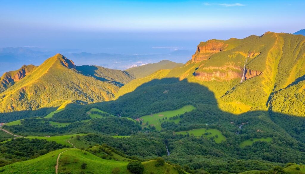
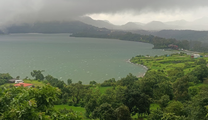
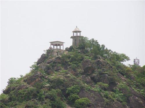
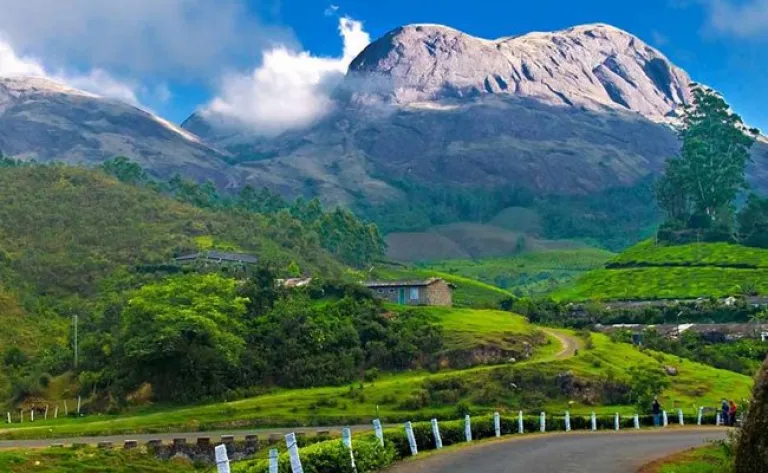
Your Complete Khajjiar Travel Guide (Mini Switzerland Tips) Nestled in the Chamba district of Himachal Pradesh, Khajjiar is renowned for its enchanting beauty—a saucer-shaped meadow surrounded by dense deodar forests, a shimmering lake, and majestic Himalayan vistas. Known as the “Mini Switzerland of India,” this hidden gem exudes both natural charm and cultural heritage. Officially recognized as one of only 160 places worldwide that resemble Switzerland (as marked by the Swiss Ambassador on July 7, 1992), Khajjiar offers travelers an experience that is as rich in history as it is in scenic allure. In this guide, we will explore Khajjiar’s history, attractions, activities, accommodation options, practical travel tips, and seasonal weather patterns. Whether you are planning a day trip from Dalhousie or a longer stay to savor the peaceful ambiance, read on for everything you need to know about Khajjiar Tourism, Khajjiar Sightseeing, and the best time to visit this Himalayan paradise. Introduction: Discover the Magic of Khajjiar Khajjiar captivates visitors with its picturesque landscapes—a vast green meadow with Khajjiar Lake at its heart and a backdrop of the formidable Dhauladhar ranges. Often compared to Switzerland for its immaculate beauty and serene environment, Khajjiar offers an oasis for travelers seeking an escape from bustling city life. From adventure sports such as paragliding and zorbing to peaceful nature walks and visits to ancient temples, there’s something here for everyone. Why Visit Khajjiar? The Allure of India’s Mini Switzerland A Natural Wonderland Khajjiar’s most irresistible draw is its natural beauty. The sweeping green meadows, bordered by dense deodar and pine forests, provide a perfect canvas against the dramatic Himalayan backdrop. The shimmering Khajjiar Lake adds a touch of tranquility, while the region’s ever-changing weather—from misty monsoons to snowy winters—ensures a distinct charm in every season. Rich History and Cultural Significance The history of Khajjiar is deeply intertwined with that of the Chamba region. Once a capital for the Rajput rulers and later influenced by Mughal, Sikh, and British colonial eras, its past is evident in heritage sites such as the 12th-century Khajji Nag Temple. This temple, with its intricate wood carvings and a blend of Hindu and Mughal architecture, offers a window into the spiritual legacy of the area. The tradition of naming the location “Khajjiar” itself stems from myth and history, making it a fascinating destination for cultural explorers. Adventure and Recreational Activities For the active traveler, Khajjiar provides a plethora of activities: A Glimpse into History Khajjiar’s history is as captivating as its landscapes. Historically a favorite summer retreat during the British colonial period, this hill station was developed alongside Dalhousie as an escape from the heat of the plains. The ancient Khajji Nag Temple, dedicated to the serpent deity, dates back to at least the 12th century and reflects the rich cultural syncretism of the region. Over the centuries, the influence of Rajput, Mughal, Sikh, and British administrations has left its mark on the local architecture and traditions, making Khajjiar a repository of historical narratives. Best Time to Visit Khajjiar: Weather and Seasons Understanding Khajjiar Weather is key to planning your visit. The region offers distinct seasonal experiences—each presenting its own charm: Season Months Temperature Range (°C) Weather & Activities Summer April – June 17 – 38 Pleasant, sunny days with cool, crisp nights. Ideal for trekking, paragliding, boating, and sightseeing at Khajjiar Lake. Monsoon July – September 24 – 34 Moderate rainfall gives way to lush greenery and misty hills. Perfect for nature walks, boating, and temple visits (e.g., Khajji Nag Temple). Winter November – March 6 – 27 (can drop sub-zero) Snowfall transforms Khajjiar into a winter wonderland. Great for snow treks, viewing the striking Lord Shiva Statue amidst snow, and experiencing true snowfall. How to Reach Khajjiar Khajjiar is well-connected, and getting there is part of the adventure. By Air By Train By Road Getting Around Khajjiar Within Khajjiar, transportation is simple: Top Attractions in Khajjiar Khajjiar offers a mix of natural beauty, spirituality, and adventure. Here are the must-see sights: 1. Khajjiar Lake 2. Khajji Nag Temple 3. Panch Pandav Tree 4. Kalatop Wildlife Sanctuary 5. Golden Devi Temple 6. Lord Shiva Statue Things to Do in Khajjiar: Activities and Experiences Adventure Sports Trekking and Nature Walks Cultural Immersion Accommodation in Khajjiar Khajjiar offers a range of options to suit every budget: Accommodation Type Examples Description Approximate Cost (INR per night) Luxury Hotels Fortune Khajjiar Plush rooms, modern amenities, scenic views, and premium services. 5,000 – 10,000 Heritage Guesthouses Deodar Manor Traditional charm, home-cooked meals, and cultural immersion in a quaint setting. 3,000 – 6,000 Budget Hotels Hotel Royal Residency, Shining Star Resort Basic amenities, comfortable stays near key attractions. 1,500 – 3,000 Homestays Himalayan Canvas, The Hosteller Khajjiar Authentic local hospitality with meals and guided tours, ideal for an immersive cultural experience. 1,000 – 2,500 Booking Tip:• Book in advance during peak seasons (Summer and Winter) as accommodations fill up quickly. Dining and Local Cuisine While dining options in Khajjiar may be limited compared to larger cities, you are sure to enjoy a delightful culinary experience: Nearby Attractions and Excursions Khajjiar’s location makes it an excellent base for exploring the surrounding region: Dalhousie Chamba Dainkund Peak Practical Travel Tips To ensure a hassle-free and memorable trip to Khajjiar, keep these suggestions in mind: Frequently Asked Questions (FAQs) Q1: What makes Khajjiar known as the “Mini Switzerland of India”?A: Khajjiar is dubbed the “Mini Switzerland of India” due to its striking resemblance to Swiss landscapes. Its lush green meadows, quaint lake, and the surrounding Himalayan backdrop create an ambiance reminiscent of the scenic beauty found in Switzerland. Q2: What is the best time to visit Khajjiar?A: Q3: How can I reach Khajjiar?A: Q4: How many days are enough to explore Khajjiar?A: While a day trip is possible, a 2-3 day visit is ideal to fully enjoy the attractions, activities, and the serene environment of Khajjiar. Q5: What activities are available in Khajjiar?A: You can enjoy a variety of activities including paragliding, zorbing, horse riding,

Khajjiar: Your Ultimate Guide to India’s Mini Switzerland Read More »

Jaipur, Hawa Mahal

Jaipur Travel Guide: Pink City Sights, Best Time & Tips | Your India Trip

Your Ultimate Jaipur Travel Guide: Exploring the Pink City’s Wonders & Planning Your Visit Imagine wandering through a city where every corner seems to glow in warm shades of terracotta, where centuries-old palaces whisper secrets of royal grandeur, and vibrant bazaars invite you to explore a kaleidoscope of colors, aromas, and textures. Welcome to Jaipur, the enthralling capital of Rajasthan and the city famously known as the Pink City. In this guide, we’ll take you on an immersive journey through Jaipur’s illustrious heritage, architectural wonders, flavorful cuisine, and practical travel tips to ensure you experience its magic to the fullest. Introduction: A City That Beckons With Royal Charm Stepping into Jaipur is like opening the pages of a living history book. Founded in 1727 by Maharaja Sawai Jai Singh II, Jaipur is renowned for its visionary urban planning, rich cultural tapestry, and an unmistakable pink hue that has come to define its identity. As you meander through the bustling streets, the city’s blend of regal heritage and contemporary flair reveals itself at every turn—whether you’re admiring centuries-old forts, savoring delectable Rajasthani cuisine, or simply soaking in the vibrant atmosphere of its bustling markets. This detailed guide aims to answer all those burning questions that internet searches frequently raise: Why is Jaipur called the Pink City? What to see in Jaipur? How is the weather, and what is the best time to visit? Plus, we delve into practical travel tips and insider experiences to help you plan an unforgettable adventure in this enchanting destination. Let’s begin our journey through Jaipur, a city where history, culture, and modern vibrancy come together in an unforgettable way. Why Is Jaipur Called the Pink City? The Royal Welcome A Historical Gesture of Hospitality One of the most captivating aspects of Jaipur is its iconic pink hue. But why is Jaipur called the Pink City? The story dates back to 1876 when Maharaja Sawai Ram Singh I decided to prepare his city for the visit of Prince Albert Edward, the Prince of Wales. In an extraordinary gesture of hospitality, the entire city was painted a warm terracotta pink—a color traditionally associated with welcoming and warmth in India. This bold transformation left such an impression on the visiting dignitary that the nickname “Pink City” stuck over the years. The Visual Impact of Pink Today, the terracotta facades of Jaipur’s historic buildings continue to narrate this tale. Walking through the Old City, you witness an uninterrupted cascade of pink hues that not only serve as a visual delight but also carry a profound historical significance. The consistent color scheme, maintained by successive generations through municipal regulations, reinforces the city’s identity, making it instantly recognizable and deeply evocative of its regal past. What Is Jaipur Famous For? Beyond the Pink Walls Architectural Marvels Jaipur is famous for its architectural riches that span centuries. At the heart of its fame are grand forts, royal palaces, and historical observatories that echo with the power and sophistication of its erstwhile rulers. Here are a few of the standout attractions: Cultural Heritage and Traditions Beyond its architectural splendors, Jaipur is a thriving cultural hub. The city pulses with vibrant festivals, traditional music, and dance performances that capture the essence of Rajasthani life. Whether it’s the exuberance of the Elephant Festival, the kaleidoscopic Teej Festival, or the lively Kite Festival celebrated every January, there is always a reason to revel in the local traditions. Handicrafts and Bazaars Jaipur’s bustling markets are a treasure trove for art lovers and collectors. The city is famous for: Culinary Delights When it comes to food, Jaipur offers a gastronomic adventure that tantalizes the taste buds with traditional Rajasthani flavors: Must-See Attractions in Jaipur: A Detailed Tour Jaipur is a city of contrasts where every monument holds a story waiting to be discovered. Here are the not-to-be-missed attractions that every visitor should add to their itinerary: Amber Fort Overview:Perched on the outskirts of Jaipur, Amber Fort is one of Rajasthan’s most majestic landmarks. Constructed in the 16th century, the fort is an architectural marvel that artfully combines elements of Hindu and Mughal design. Visitor Tips: Hawa Mahal Overview:Famed as the “Palace of Winds,” Hawa Mahal is an architectural wonder with its delicate latticework and an array of small windows designed to catch breezes. Built in 1799, it provided the royal ladies with a discreet vantage point to observe everyday life. Visitor Tips: City Palace Overview:Located within the heart of Jaipur, the City Palace is both a museum and a residence. Its labyrinthine corridors, grand courtyards, and lavish halls offer a window into the lives of the former royals and their enduring legacy. Visitor Tips: Jantar Mantar Overview:A marvel of scientific innovation, Jantar Mantar is the largest stone astronomical observatory in the world. Built by Maharaja Sawai Jai Singh II, its collection of instruments offers insight into the astronomical practices of the 18th century. Visitor Tips: Jal Mahal Overview:The ethereal Jal Mahal, or “Water Palace,” seems to float gracefully on Man Sagar Lake. Its unique architecture and enchanting setting have made it one of Jaipur’s most photographed landmarks. Visitor Tips: Experiences in Jaipur: More Than Just Sightseeing Jaipur offers a wealth of experiences that go beyond visiting monuments. Here are some unique activities that add a special touch to your trip: Aerial Adventures and Hot Air Balloon Rides For those seeking a bird’s-eye view of the Pink City and its mesmerizing landscape, hot air balloon rides provide an unforgettable perspective. Floating gently over Jaipur’s forts, palaces, and sprawling greenery, you can marvel at the sheer scale and beauty of the city from above. (Before booking, check for current prices as these can vary.) Hands-On Workshops and Artisanal Experiences Immerse yourself in the local culture through: Exploring the Bustling Bazaars No trip to Jaipur is complete without wandering through its vibrant markets: Cultural Evenings and Traditional Performances Embrace the cultural richness of Jaipur by attending: Romantic Jaipur and Couples’ Retreats Jaipur is often considered a romantic destination. Its quaint cafés,

Jaipur Travel Guide: Pink City Sights, Best Time & Tips | Your India Trip Read More »